Editor’s Note: This is a weekly column written by Meteorologist Joel Gratz that will take you “behind the scenes” of the typical weather forecast. Joel is the founder of ColoradoPowderForecast.com, where you can sign up for his email alerts.
Boulder, CO – The word “epic” gets thrown around far too often. If every day with fresh snow is “Epic,” then the word truly loses its meaning.nLuckily, I’m here to kill the buzz around every day being “epic”, and would like to throw out a fantastically not-cool phrase to anchor the conversation: snow density.
Before you roll your eyes at any bit of science that makes it into the vernacular of
powder skiers (and riders), consider that snow density is the real key to making or
breaking a powder day.
Snow density refers to the “fluffiness” of the snow that falls, and is computed by looking
at the total depth of the snow versus the liquid equivalent of the snow if it were melted.
High density snow has high water content and low density snow has low water content.
For “epic” powder days with “epic” photographs of “epic” face shots, we are always
looking for low-density snow; the type that’s light, fluffy, and will gladly ride up your
knees and hit you in the face. This type of snow typically comes from a storm that
pulls moisture from a drier, continental airmass. While a drier airmass won’t always
produce the biggest snow totals, the right combination of temperature, wind direction,
wind speed, and topography can easily pull lots of snow flakes out of relatively little
moisture in the air. This is the good stuff where 12 to 24 inches can provide face shots all day
long.
The converse is when storms pull moisture straight from an ocean source, which
typically means more water content in the snow. While this snow is still fun to ski, it is
usually described more as “creamy” or “heavy” rather than “light and fluffy”, and it often
doesn’t produce “epic” powder days.
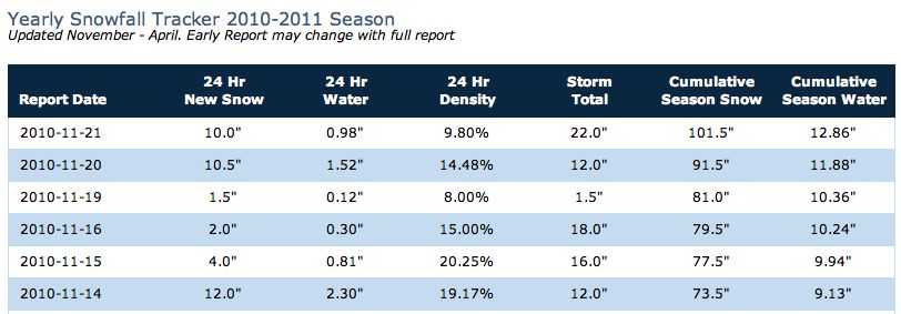
Alta, Utah is the only resort that I know of that consistently tracks snow density. They
compute the number by dividing the inches of liquid water equivalent by the inches of
snow. For example, if one inch of liquid equivalent produced 10 inches of snow, the
snow density would be 1/10 = .10 = 10%. This would be considered a middle-of-the-road
density, with less than 5% really considered blower pow. The last few storms that hit Alta
produced snow densities ranging from eight to 15%. While this is not terribly heavy snow, it’s not quite
blower pow either. The storms that produced this snow drew in moisture from the Pacific
Ocean which is why the snow was a bit heavier.
Take a peek at Alta’s chart of snow
density below, and keep searching for that “epic” day of blower, low density pow!
|
(Source: Alta Ski Area) |