Editor’s Note: This is a weekly column written by Meteorologist Joel Gratz that will take you “behind the scenes” of the typical weather forecast. Joel is the founder of ColoradoPowderForecast.com, where you can sign up for his email alerts.
Boulder, CO – Sometimes I feel like I’m in the CIA, sweating the stuff that most people just take for granted. In much the same way that some CIA operative may realize how close we were to a war while others slept blissfully ignorant of the potential doom, at times I realize how thin the line is between a huge powder day and a partly sunny day with some flurries.nOK, the parallel between snow forecaster and CIA operative isn’t perfect, but it’s one way to think of things.
This week and into early next week, some of the eastern states in the Rockies — Montana, Wyoming and Colorado — saw multiple snowstorms and some great powder days. But these states are just “on the edge” of the storm track, and a shift in the jet stream by 100 to 200 miles in either direction can make the difference between a memorable day of deepness and sunny skies.
The image below shows the general position of the jet stream for this upcoming weekend. The northward bulge over the western states signifies dry and warm weather, while the southward shift over the east points toward snowier and colder weather.
|
|
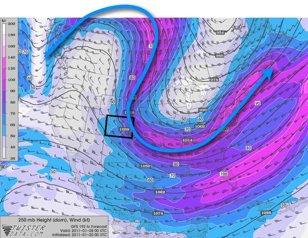
Notice that Colorado, outlined in black, is just on the edge of the jet stream. If the storm track moved any further east, Colorado would be high and dry. If the opposite happened, more snow could work its way back into the state.
To humans, the difference between a storm hitting or not hitting might seem like a big deal (and it is). However to the atmosphere, a small re-position of the jet stream of 100-200 miles is a miniscule change. I like to say that it’s just a game of inches, atmospheric inches at that.
This is why forecasts further out than five to seven days should be treated with skepticism, as the weather computer model’s ability to predict the position of the jet stream 168 hours (seven days) in advance has an error of at least 100-plus miles. That’s more than enough to be the difference between a sunny day and a “sick” day.