J.Spin
New member
A link to more pictures and video is available at the bottom of the report.
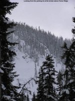
On Sunday we had a rather grandiose scheme to let Mom get some Chair 4 ski time with Ty, and allow the whole family to ski together. We decided to station ourselves at the new Lost Trail yurt, taking advantage of its location near the base of Chair 4. As I'd found out on Saturday, this was really the best solution for taking multiple runs off Chair 4 with Ty, since it can take quite a while just getting over to Chair 4 with him, depending on his mood and the speed of the snow. The most challenging part of setting up camp at the yurt was getting everything (Food, kid supplies, Ty, Dylan, etc.) over there. In the end, E had a full backpack, and Ty on the leash, and I had a very full backpack on my back, and Dylan in a carrier on the front. We got a lot of looks, questions, and compliments as we got set up at the main base and prepared to load Chair 1.
Although I was carrying a rather heavy load between Dylan and my backpack, we skied easy green trails all the way down from the main summit to the yurt, so it turned out to be a piece of cake. We took the North Bowl/Speedway/Candy Stick/Easy Street/Candy Stick route that I had discovered on Saturday. It had been great on Saturday, but there had been some new snow overnight and now it was really slow. Ty insisted on walking in many areas instead of being pulled by the leash, and this slowed us down even more. Since Ty had wowed me on Saturday by insisting that he could ski the Bunny Hill all alone, and then doing it, we let him ski a couple of the flatter sections alone on the route over to Chair 4. He did well, but it was obvious that we still had to use the leash for the steeper pitches. All told, I think it took over an hour to get to the bottom of Chair 4, and by the time we parked the skis and walked over to the yurt, it was late enough to have lunch. Ty walked over to the food service area in the yurt and grabbed one of the monster cinnamon buns. Fortunately, I had remembered to pack the remaining 90% of the cinnamon bun that he still had left from the previous day, so he was happy with that.
While the rest of the family finished lunch, I took a quick run on Chair 4 by myself. I rode the chair with a woman from somewhere in the area, and in conversation in came up that we were from Vermont. She commented on how the conditions here must be quite different than what we skied in Vermont. She was amazed when I informed her that we were from northern Vermont, and that actually, the conditions weren,t much different in terms of powder skiing than what we had here at Lost Trail. I explained that there was a higher chance of above-freezing conditions compare to Lost Trail (which typically gets above freezing at 7,000' maybe once or twice at most during the heart of the season) but that for the most part I skied as much quality powder when I lived in northern Vermont as I did here at Lost Trail. She was especially blown away to learn that Jay Peak had a higher annual snowfall than Lost Trail. We also talked about outdoor activities with kids, and it was interesting to learn that she used to mountain bike with one of her kids in a front pack. Skiing green runs with Dylan in the front pack seems pretty tame by comparison.
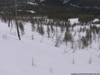
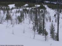
For my run, I jumped into The Slot, and then cut left into the trees to do a little reconnaissance for Ty. The Slot had few tracks, and I got some sweet powder turns on the steep terrain before cutting left into the sparse trees. I was hoping the powder in the trees hadn't changed too much or become too deep, since Ty had done so well on Saturday's surface. There was a lot of nice untracked snow in the steep trees, which I liked, and it seemed like Ty would still be able to handle it. I then hit assorted groomed options around the lift line for a little high speed cruising, and returned to the yurt.
We geared up for skiing with the boys, our overall loads much lighter now that E and I were able to drop our backpacks and leave them in the yurt. Now, I wore Dylan in the front pack and carried the still and video cameras in one of our usual Mountainsmith lumbar packs, which added minimal weight and bulk compared to the big pack. E carried no extra baggage, so she could easily deal with loading and sitting with Ty on the chairlift. One of the day's goals was to get E comfortable with loading Ty on the lifts, so that in the future, she would be able to take him out for runs while I watched Dylan. By this point, she already had the loading and unloading techniques down pretty well, and by the end of the day she was looking really smooth and comfortable.
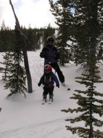
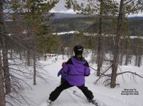
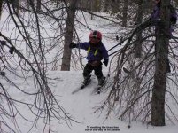
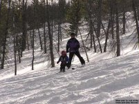
We did three runs in the Chair 4 trees, followed by options on the groomed trails below. Ty had a really good time in the trees, and as he'd done frequently on Saturday, he would sometimes smack the branches of the trees as he passed them. At times this may have been to push them out of the way, but mostly he still just enjoyed the novelty of it. On one of the runs I shot a little video in the trees, which was recorded in the trees between the Chair 4 lift line and Two Dot, just below the mid-station. I'd brought one of our video cameras, but the color balance was acting up so I ended up shooting a little video with our still camera. I quickly pasted together a couple of the raw clips with QuickTime and you can download the video from the web page link at the bottom of the report. Ty tended to want to head right down into the trees when we got off the lift, so the first couple of runs were in trees near the lift line. But on the third run, we were able to traverse over near Sacajewea and Lewis and Clark and try some different tree lines. On that run I shot a bunch of stills, and some of those are on the web page as well. As for the groomed skiing, I introduced E to what Ty had been doing with me when we had skied the lift line the previous day - he had enjoyed jumping off the little areas around the lift towers where the snow had been groomed to slightly different levels. It gave him something to focus on during the run, and as he says, he likes to "jump". By the third Chair 4 run, he was trying to do this off of every little powdery mound we found on Lewis and Clark, and E said that it was his primary focus. Most of the mounds were so soft that he didn't really get much in the way of a jump, but at least it made him turn a bit more since he was motivated to get to the various mounds of snow.
By the third run, Ty was getting pretty tired, so we got our packs from the yurt, loaded back up, and headed up Chair 3. I was feeling like I'd hardly done a thing during the day, since skiing around with Dylan in the front pack and taking photos and video was far easier than managing Ty's skiing for several runs. Dylan slept much of the time, and when he was awake, he was preoccupied with watching all the trees go by in this interesting new environment. I was really thankful that E took over for the day with Ty, as he'd worn me out pretty nicely the previous day and it was good to have a break.
Instead of returning to the base via Chair 5 and the rope tow, we just walked over to the parking lot from Chair 3. For the first time ever, Ty actually fell asleep on the chairlift! So, it seemed like getting him to the car as soon as possible was the way to go. E hung out with the boys, and I went and grabbed the car. During this time, Ty had a bit of resurgence in his energy (possibly due to his brief "nap"), and he felt he needed to play in the snow. He walked around with his skis in the powder near the parking lot, but unfortunately he would sometimes fall down and ask for assistance to get back up. Well, the soft snow was waist deep in this area, so helping him meant post-holing, and snow up the pants and down the boots for Mom and Dad (who were now out of their ski boots). On of the trips to help Ty, E wisely crawled out instead of post-holing, and I got a couple of pictures. I think Ty found the whole process amusing, and he didn't seem all that anxious to get rescued when he fell. He seemed to enjoy lying in the snow in his semi-tired state.
So, although it took a lot of planning and load carrying to spend the day with both boys over at Chair 4 and the yurt, it was worth getting to spend the time with the whole family.
Additional pictures and video from the day are available at:
http://www.JandEproductions.com/2006/08JAN06.html
J.Spin
On Sunday we had a rather grandiose scheme to let Mom get some Chair 4 ski time with Ty, and allow the whole family to ski together. We decided to station ourselves at the new Lost Trail yurt, taking advantage of its location near the base of Chair 4. As I'd found out on Saturday, this was really the best solution for taking multiple runs off Chair 4 with Ty, since it can take quite a while just getting over to Chair 4 with him, depending on his mood and the speed of the snow. The most challenging part of setting up camp at the yurt was getting everything (Food, kid supplies, Ty, Dylan, etc.) over there. In the end, E had a full backpack, and Ty on the leash, and I had a very full backpack on my back, and Dylan in a carrier on the front. We got a lot of looks, questions, and compliments as we got set up at the main base and prepared to load Chair 1.
Although I was carrying a rather heavy load between Dylan and my backpack, we skied easy green trails all the way down from the main summit to the yurt, so it turned out to be a piece of cake. We took the North Bowl/Speedway/Candy Stick/Easy Street/Candy Stick route that I had discovered on Saturday. It had been great on Saturday, but there had been some new snow overnight and now it was really slow. Ty insisted on walking in many areas instead of being pulled by the leash, and this slowed us down even more. Since Ty had wowed me on Saturday by insisting that he could ski the Bunny Hill all alone, and then doing it, we let him ski a couple of the flatter sections alone on the route over to Chair 4. He did well, but it was obvious that we still had to use the leash for the steeper pitches. All told, I think it took over an hour to get to the bottom of Chair 4, and by the time we parked the skis and walked over to the yurt, it was late enough to have lunch. Ty walked over to the food service area in the yurt and grabbed one of the monster cinnamon buns. Fortunately, I had remembered to pack the remaining 90% of the cinnamon bun that he still had left from the previous day, so he was happy with that.
While the rest of the family finished lunch, I took a quick run on Chair 4 by myself. I rode the chair with a woman from somewhere in the area, and in conversation in came up that we were from Vermont. She commented on how the conditions here must be quite different than what we skied in Vermont. She was amazed when I informed her that we were from northern Vermont, and that actually, the conditions weren,t much different in terms of powder skiing than what we had here at Lost Trail. I explained that there was a higher chance of above-freezing conditions compare to Lost Trail (which typically gets above freezing at 7,000' maybe once or twice at most during the heart of the season) but that for the most part I skied as much quality powder when I lived in northern Vermont as I did here at Lost Trail. She was especially blown away to learn that Jay Peak had a higher annual snowfall than Lost Trail. We also talked about outdoor activities with kids, and it was interesting to learn that she used to mountain bike with one of her kids in a front pack. Skiing green runs with Dylan in the front pack seems pretty tame by comparison.
For my run, I jumped into The Slot, and then cut left into the trees to do a little reconnaissance for Ty. The Slot had few tracks, and I got some sweet powder turns on the steep terrain before cutting left into the sparse trees. I was hoping the powder in the trees hadn't changed too much or become too deep, since Ty had done so well on Saturday's surface. There was a lot of nice untracked snow in the steep trees, which I liked, and it seemed like Ty would still be able to handle it. I then hit assorted groomed options around the lift line for a little high speed cruising, and returned to the yurt.
We geared up for skiing with the boys, our overall loads much lighter now that E and I were able to drop our backpacks and leave them in the yurt. Now, I wore Dylan in the front pack and carried the still and video cameras in one of our usual Mountainsmith lumbar packs, which added minimal weight and bulk compared to the big pack. E carried no extra baggage, so she could easily deal with loading and sitting with Ty on the chairlift. One of the day's goals was to get E comfortable with loading Ty on the lifts, so that in the future, she would be able to take him out for runs while I watched Dylan. By this point, she already had the loading and unloading techniques down pretty well, and by the end of the day she was looking really smooth and comfortable.
We did three runs in the Chair 4 trees, followed by options on the groomed trails below. Ty had a really good time in the trees, and as he'd done frequently on Saturday, he would sometimes smack the branches of the trees as he passed them. At times this may have been to push them out of the way, but mostly he still just enjoyed the novelty of it. On one of the runs I shot a little video in the trees, which was recorded in the trees between the Chair 4 lift line and Two Dot, just below the mid-station. I'd brought one of our video cameras, but the color balance was acting up so I ended up shooting a little video with our still camera. I quickly pasted together a couple of the raw clips with QuickTime and you can download the video from the web page link at the bottom of the report. Ty tended to want to head right down into the trees when we got off the lift, so the first couple of runs were in trees near the lift line. But on the third run, we were able to traverse over near Sacajewea and Lewis and Clark and try some different tree lines. On that run I shot a bunch of stills, and some of those are on the web page as well. As for the groomed skiing, I introduced E to what Ty had been doing with me when we had skied the lift line the previous day - he had enjoyed jumping off the little areas around the lift towers where the snow had been groomed to slightly different levels. It gave him something to focus on during the run, and as he says, he likes to "jump". By the third Chair 4 run, he was trying to do this off of every little powdery mound we found on Lewis and Clark, and E said that it was his primary focus. Most of the mounds were so soft that he didn't really get much in the way of a jump, but at least it made him turn a bit more since he was motivated to get to the various mounds of snow.
By the third run, Ty was getting pretty tired, so we got our packs from the yurt, loaded back up, and headed up Chair 3. I was feeling like I'd hardly done a thing during the day, since skiing around with Dylan in the front pack and taking photos and video was far easier than managing Ty's skiing for several runs. Dylan slept much of the time, and when he was awake, he was preoccupied with watching all the trees go by in this interesting new environment. I was really thankful that E took over for the day with Ty, as he'd worn me out pretty nicely the previous day and it was good to have a break.
Instead of returning to the base via Chair 5 and the rope tow, we just walked over to the parking lot from Chair 3. For the first time ever, Ty actually fell asleep on the chairlift! So, it seemed like getting him to the car as soon as possible was the way to go. E hung out with the boys, and I went and grabbed the car. During this time, Ty had a bit of resurgence in his energy (possibly due to his brief "nap"), and he felt he needed to play in the snow. He walked around with his skis in the powder near the parking lot, but unfortunately he would sometimes fall down and ask for assistance to get back up. Well, the soft snow was waist deep in this area, so helping him meant post-holing, and snow up the pants and down the boots for Mom and Dad (who were now out of their ski boots). On of the trips to help Ty, E wisely crawled out instead of post-holing, and I got a couple of pictures. I think Ty found the whole process amusing, and he didn't seem all that anxious to get rescued when he fell. He seemed to enjoy lying in the snow in his semi-tired state.
So, although it took a lot of planning and load carrying to spend the day with both boys over at Chair 4 and the yurt, it was worth getting to spend the time with the whole family.
Additional pictures and video from the day are available at:
http://www.JandEproductions.com/2006/08JAN06.html
J.Spin