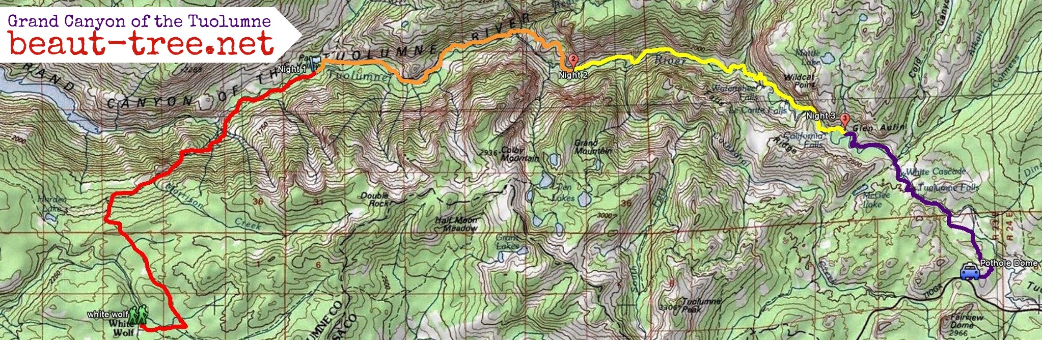
I have hiked down the Tuolumne River from Tuolumne Meadows before in 1985 and 2006, but both times later in the year. Nonetheless this is the first time I've made it to the Glen Aulin camp. Map of our route drawn in purple:

We had to pack and also had a big breakfast at The Stove in Mammoth. Thus we parked near Pothole Dome at the south end of Tuolumne Meadows about 10:30AM.

This shortens the hike downstream but is not on an established trail. At Memorial Day of a normal snow year most but not all of the snow is gone, but the river is high, thus the scenic attraction for us. There are also a lot of swampy meadows, standing water and high flowing tributaries. This cuts down hiker traffic on the trail north of the river that can be quite busy mid-summer. The south side upstream from the bridge above Tuolumne Falls is quieter and we saw zero other people there during the first 2 1/2 hours of our hike.
We started along the road to skirt the wet meadow and hiked north into the forest west of pothole dome. Trees were spaced and there was minimal brush but we had to avoid a few wet patches and get through a few snow patches. We reached the Tuolumne River in about an hour.

The river widens just past this area and in spring overflows into ponds and meadows. So we were back in the forest for awhile. Here we were able to cut across a drier section of the meadow.

Now we're in a snowbank next to the large overflow pond.

I postholed once.

Finally we reach the Tuolumne River flowing more swiftly over granite.

And a section with snow still covering the granite to river's edge.

At 1PM we stopped for lunch overlooking a narrow gorge.

Looking up at our lunch rock from about 100 yards downstream.

We had to climb up over some rocks where water covered the more direct route along the river.

Around 2PM we were at the upper section of Tuolumne Falls.

The bridge above brings the trail to the south side of the river, but we walked mostly along the granite for better views


The Tuolumne continues cascading down the granite.

I have not found out why the small hut on the other side is there.
White Cascade is the final drop above Glen Aulin.

Supposedly that's a swimming hole in mellower mid summer conditions.
We continued 1.4 mile farther to the Glen Aulin High Sierra Camp. https://en.wikipedia.org/wiki/High_Sier ... ierra_Camp

In July/August this is one of 6 Yosemite high country camps where tents with cots and meals are provided, similar to the multiday hikes Liz and I did in Patagonia in 2011 and New Zealand in 2012. My understanding is that there is a lottery for the limited number of slots.
But it's still early season with high water and we saw only 3 people during the 2+ hours we were in the spectacular scenery below the Tuolumne Falls bridge. Here's some of that high water on the approach to the Glen Aulin bridge.

We headed back up at 3:15, staying on trail and reaching the Tuolumne Falls bridge an hour later, also with high water on its approach.

We should have retraced our route south of the river, but we thought due to the late hour it would be more sensible to return via the established trail. The first hour or so was fine, and we soon reached the wide section of the river with a view south to 10,911 foot Cathedral Peak.

The established Glen Aulin trail north of the Tuolumne river is crossed by several creeks, which in high water can be considerable obstacles. We did not find a bridge across Dingley Creek, but it was shallow where it crossed the trail so we removed our shoes to cross here.

This was not difficult but there was quite a shock from the cold by the time we made it across.
Fortunately we found a fallen log to cross this creek.

Here we had a nice view from Unicorn Peak at left to Cathedral Peak at right.

We arrived at Delaney Creek about 6:15PM. We were told by an Aussie backpacker headed downstream that there was a log crossing for this one. We soon found these.


Unfortunately these only got us to the west bank of an island where Delaney Creek had split and we found no logs across the east bank. We retreated and followed the creek all the way to the Tuolumne, hoping it would spread out in the meadow to allow a foot crossing. But everywhere there was a fairly swift channel of indeterminate depth which we did not want to risk. We headed upstream past the island and eventually found the Aussie's log, where the swift current occasionally splashed over it. Exhausted and concerned with getting across safely, Liz and I both neglected to take any pictures there. It took us a full hour to find this crossing.
Finally the end is near approaching Lembert Dome.

At twilight deer were feeding in many places near the trailhead.

Note the enticing snowfield on the north side of Unicorn Peak in the background. Liz and I hiked to Elizabeth Lake in that direction in May 2012.
There were 3 cars of campers at the Lembert Dome trailhead when we arrived at 8:15PM, and one of them gave us a ride to our car at the other end of Tuolumne Meadows.
We had to pack and also had a big breakfast at The Stove in Mammoth. Thus we parked near Pothole Dome at the south end of Tuolumne Meadows about 10:30AM.
This shortens the hike downstream but is not on an established trail. At Memorial Day of a normal snow year most but not all of the snow is gone, but the river is high, thus the scenic attraction for us. There are also a lot of swampy meadows, standing water and high flowing tributaries. This cuts down hiker traffic on the trail north of the river that can be quite busy mid-summer. The south side upstream from the bridge above Tuolumne Falls is quieter and we saw zero other people there during the first 2 1/2 hours of our hike.
We started along the road to skirt the wet meadow and hiked north into the forest west of pothole dome. Trees were spaced and there was minimal brush but we had to avoid a few wet patches and get through a few snow patches. We reached the Tuolumne River in about an hour.
The river widens just past this area and in spring overflows into ponds and meadows. So we were back in the forest for awhile. Here we were able to cut across a drier section of the meadow.
Now we're in a snowbank next to the large overflow pond.
I postholed once.
Finally we reach the Tuolumne River flowing more swiftly over granite.
And a section with snow still covering the granite to river's edge.
At 1PM we stopped for lunch overlooking a narrow gorge.
Looking up at our lunch rock from about 100 yards downstream.
We had to climb up over some rocks where water covered the more direct route along the river.
Around 2PM we were at the upper section of Tuolumne Falls.
The bridge above brings the trail to the south side of the river, but we walked mostly along the granite for better views
The Tuolumne continues cascading down the granite.
I have not found out why the small hut on the other side is there.
White Cascade is the final drop above Glen Aulin.
Supposedly that's a swimming hole in mellower mid summer conditions.
We continued 1.4 mile farther to the Glen Aulin High Sierra Camp. https://en.wikipedia.org/wiki/High_Sier ... ierra_Camp
In July/August this is one of 6 Yosemite high country camps where tents with cots and meals are provided, similar to the multiday hikes Liz and I did in Patagonia in 2011 and New Zealand in 2012. My understanding is that there is a lottery for the limited number of slots.
But it's still early season with high water and we saw only 3 people during the 2+ hours we were in the spectacular scenery below the Tuolumne Falls bridge. Here's some of that high water on the approach to the Glen Aulin bridge.
We headed back up at 3:15, staying on trail and reaching the Tuolumne Falls bridge an hour later, also with high water on its approach.
We should have retraced our route south of the river, but we thought due to the late hour it would be more sensible to return via the established trail. The first hour or so was fine, and we soon reached the wide section of the river with a view south to 10,911 foot Cathedral Peak.
The established Glen Aulin trail north of the Tuolumne river is crossed by several creeks, which in high water can be considerable obstacles. We did not find a bridge across Dingley Creek, but it was shallow where it crossed the trail so we removed our shoes to cross here.
This was not difficult but there was quite a shock from the cold by the time we made it across.
Fortunately we found a fallen log to cross this creek.
Here we had a nice view from Unicorn Peak at left to Cathedral Peak at right.
We arrived at Delaney Creek about 6:15PM. We were told by an Aussie backpacker headed downstream that there was a log crossing for this one. We soon found these.
Unfortunately these only got us to the west bank of an island where Delaney Creek had split and we found no logs across the east bank. We retreated and followed the creek all the way to the Tuolumne, hoping it would spread out in the meadow to allow a foot crossing. But everywhere there was a fairly swift channel of indeterminate depth which we did not want to risk. We headed upstream past the island and eventually found the Aussie's log, where the swift current occasionally splashed over it. Exhausted and concerned with getting across safely, Liz and I both neglected to take any pictures there. It took us a full hour to find this crossing.
Finally the end is near approaching Lembert Dome.
At twilight deer were feeding in many places near the trailhead.
Note the enticing snowfield on the north side of Unicorn Peak in the background. Liz and I hiked to Elizabeth Lake in that direction in May 2012.
There were 3 cars of campers at the Lembert Dome trailhead when we arrived at 8:15PM, and one of them gave us a ride to our car at the other end of Tuolumne Meadows.