Editor’s Note: This is the first column in a weekly series written by Meteorologist Joel Gratz that will take you “behind the scenes” of the typical weather forecast. Joel is the founder of ColoradoPowderForecast.com, where you can sign up for his email alerts.
Boulder, CO – One of the most important concepts I learned in my meteorology classes at Penn State (’03) was to never trust the exact predictions of weather computer models. While these technological masterpieces have come an incredibly long way since they were first crafted on the rudimentary computers of the 1950s and 1960s, they’re still not perfect. But there is a secret weapon that we can use to gain an upper hand in the fight to find snow: trends.
The two main weather computer models produce a new forecast every six hours, and it’s the trend of these forecasts – rather than the exact details – that are most important to forecasting weather.
Here is a good example that occurred just a few days ago, with a happier-than-expected outcome for snow lovers.
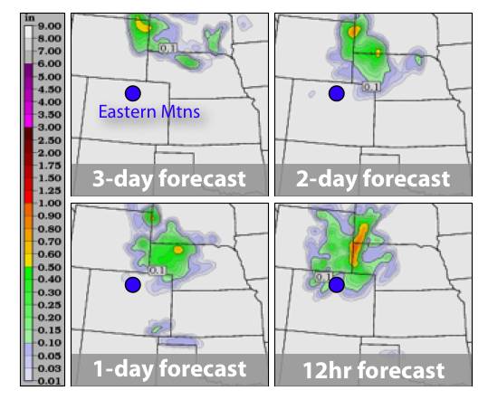
A slow moving storm was hanging out around Nebraska much of last weekend (Oct. 9-10). The computer models were forecasting that this storm would stay just far enough east to keep all of its precipitation (snow above 10,000 ft., rain below) away from the eastern mountains of Colorado. Last Thursday, Oct. 7, the three-day forecast called for no precipitation.
However, it’s all about following the trend of the models. By Friday, Oct. 8, the two-day forecast still called for very little precipitation in the mountains, but it did show that the storm would be about 200 miles closer to Colorado than previously indicated. Hmmmmm…is this the start of a trend in the models showing that the storm was actually going to impact Colorado?
Yup! On Saturday, Oct. 9, the one-day forecast hinted that the storm might be a bit stronger and closer to Colorado. And by the day of reckoning – Sunday, Oct. 10 – the storm was indeed even closer to Colorado than any previous model forecast and threw down five to 10 inches of snow on the highest mountains in northeast Colorado, including within Rocky Mountain National Park.
This graphic shows the model forecast for how much precipitation would fall between 6 p.m. Saturday and 6 a.m. Sunday. Note that the colors show amount of precipitation in liquid form, so the amounts depict either rain or the liquid equivalent of melted snow. With each new forecast, the model moved the precipitation closer to Colorado. Using the trend of the models – rather than the exact model forecast – allowed forecasters to surmise that there might be more snow in the eastern mountains than previously thought.