Editor’s Note: This is a weekly column written by Meteorologist Joel Gratz that will take you “behind the scenes” of the typical weather forecast. Joel is the founder of ColoradoPowderForecast.com, where you can sign up for his email alerts.
Boulder, CO – On the heels of 30-50 inches of snow that fell throughout Colorado over the past five days, another big storm is on tap across the entire western U.S. for next week. While this storm will nuke on the West Coast with a few feet in the forecast, more skeptical readers might inquire why there is so much confidence in a weather forecast for more than seven days into the future further inland.
That’s a great question, and the answer has everything to do with current weather, not future weather.
The weather computer models are amazing feats of engineering, but the forecasts
they produce are only as good as the data that they consume. Twice a day, weather
observations are compiled from across the globe and stuffed in to the weather computer
models as a picture of what is going on right now.
However, it’s an incomplete picture. Weather stations are often located hundreds of
miles (at least) away from each other, so we’re never sure that the current conditions fed
into the models fill in these holes between observations in the most accurate way.
The solution to this problem is to vary the current conditions just slightly, and run the
weather model for each variant of the current weather. For example, the model is run
once using the best information for current conditions, but then the model is run another
29 times, each using a slightly different take on the current conditions.
When you compare and contrast all 30 computer models, a bigger picture begins to emerge. If all 30
model runs are similar, then there is more confidence in the forecast. However if the
model solutions are all over the place, it shows that the initial conditions have a huge
impact on the forecast and confidence in an accurate forecast is much lower.
|
|
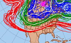 The ensemble forecast for next Tuesday, Nov. 23.
At right is an example of the ensemble forecast (using approximately 30 model runs) for next Tuesday, Nov. 23. The white lines represent the forecast using best data for initial
conditions while the other colored lines show variants of the forecast using the 29 other
slightly different initial conditions. Note that while there is some spread, also known
as “spaghetti,” all ensemble members show a big
trough, or dip, in the West. This trough will allow cold and snowy weather to stick around
through much of Thanksgiving week.
If some of the spaghetti lines were completely out of sync with each other, I would
have less confidence in a snowy forecast for next week. But because most ensemble
forecasts are providing the same snowy forecast, there is better-than-average
confidence that next week’s storm is on track to make Turkey Day a powder day.