Editor’s Note: This is a weekly column written by Meteorologist Joel Gratz that will take you “behind the scenes” of the typical weather forecast. Joel is the founder of ColoradoPowderForecast.com, where you can sign up for his email alerts.
Boulder, CO – If you’re on the East Coast, chances are you love the current weather pattern. If you’re on the West Coast, you must be cursing your local weather person for not predicting more powder.
This type of pattern – snowy in the East and dry in the West – can happen at any time, but the unique aspect about the current pattern is that it seems to be repeating itself every day for nearly a month. As the title suggests, we’re in the atmospheric version of the movie “Groundhog Day.”
Most people talk about La Niña or El Niño as a predictor of winter time snowfall, and the reason this is talked about so often is because La Niña and El Niño have some level of long-term predictability. So we can sit around in September, look at the winter predictions of La Niña, and draw some conclusions about where and when the snow will fall.
This level of long-term predictability is not the case with many other atmospheric patterns, however. Such things as the North Atlantic Oscillation (NAO) and Arctic Oscillation (AO) have profound effects on weather patterns but can’t be forecast for more than five to 10 days into the future.
Over the last few weeks, both the NAO and the AO have been in a negative phase, which basically equates to snowy and cold in the east and warmer and drier in the west. As the exact storm track shifts back and forth, some of the western mountains that are furthest east (Montana, Wyoming, Colorado) can still get snow, but for the most part the western U.S. is in a dry period.
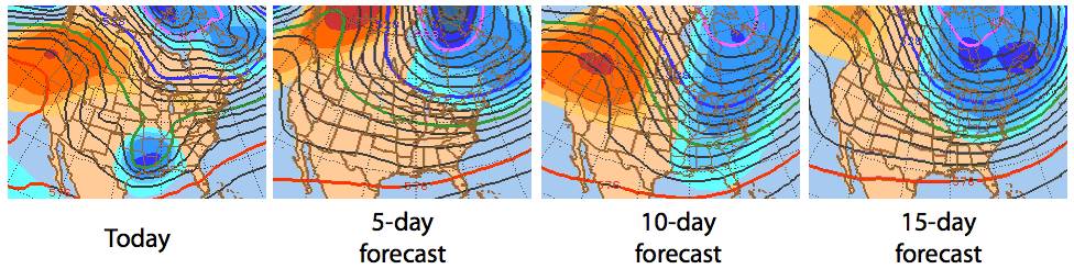
The outlook for the next one to two weeks shows the current weather pattern persisting, as the image shows below (blue colors show a cold and snowy trough in the East and red colors show a warm and dry ridge in the West). There is a hint in the long-range models that this pattern will change toward the end of the first week in February, though the specifics are this change cannot be forecast. Until any change happens, it’ll be Goundhog Day every day – so make the most of it!
|
Joel first fell in love with weather and skiing at age four, and this passion for snow has not faded with age. After earning his Meteorology degree from Penn State in 2003 and a Masters from the University of Colorado in 2006, Joel started Colorado Powder Forecast out of Boulder, Colo., to help fellow snow lovers with accurate and entertaining weather forecasts.