Editor’s Note: This is a weekly column written by Meteorologist Joel Gratz that will take you “behind the scenes” of the typical weather forecast. Joel is the founder of ColoradoPowderForecast.com, where you can sign up for his email alerts.
Boulder, CO – Forecasting snowstorms can sometimes be cut and dried. The multiple computer models agree with one another, the storm is tracking in a familiar way, and all the factors seem
to be setup for a predictable snowfall. This is the easy part of the job. The hard part of the job is when the multiple computer model forecasts disagree, the storm is very unique and nuanced, and nothing is cut and dried.nThis is exactly what’s happening with the current storm that’s moving through the Rocky Mountains this week. Rather than one big storm that predictably moves across the state from west
to east, this storm will in a sense set up some railroad tracks through the state that will allow multiple “mini-storms” embedded within the parent storm to traverse the Rockies. The details of these mini-storms are notoriously hard to pin down, and while the computer models give a good “first guess” at how the snow will fall, the forecast is far from certain.
Notice the two computer model forecasts in the graphic below. They are for the same time – just different models. The NAM model on the left is far more nuanced than the GFS model on the right as you can see specific mountain ranges where the model is forecasting more snowfall (red and yellow bulls-eyes). While the NAM predicts close to a foot or more in most mountains, the GFS is more bearish with only five to eight inches for the highest totals. In addition, the mountains of southwest Colorado (especially near Wolf Creek) show very little snowfall on the GFS but over a foot on the NAM.
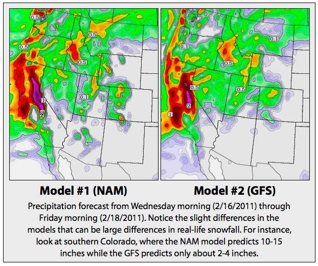
|
The experience of a weather forecaster is key for these situations. While the computer weather models are a good guide, there is still no substitute for the local knowledge of forecasters. Since I’ve been forecasting in Colorado for nearly seven years and can remember similar storms, my instinct says that the NAM model is providing the more accurate forecast for Wolf Creek because the winds are coming from a favorable southwest and west-southwest direction. Said another way – I think they’ll see good
snow from this storm, not the miniscule few inches that the GFS model predicts.
We’ll see!
Joel first fell in love with weather and skiing at age four, and this passion for snow has not faded with age. After earning his Meteorology degree from Penn State in 2003 and a Masters from the University of Colorado in 2006, Joel started Colorado Powder Forecast out of Boulder, Colo., to help fellow snow lovers with accurate and entertaining weather forecasts.