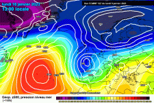
By the end of the incoming storm, I'm going to start a new Alps weather/conditions thread with a less unpleasant subject line. [Done, TC] Here's Fraser's report:
The much-anticipated storm has arrived in the Alps, but it won’t be until later tonight that all areas get in on the action. Significant snow has already fallen today in some south-western parts of the Alps and will spread to most other regions later today and overnight.
With the angle of attack initially from the south-west, it is the southern Alps (especially the south-west) that will get first dibs on the heaviest snow. At least 15cm has already fallen in Auron/Isola 2000 in the far southern French Alps, for example, with a rain/snow limit around 1400m.
Further north, there have been bits and pieces of snow in the northern French Alps (e.g. Portes du Soleil) and western Swiss Alps (e.g. Zermatt) but with a higher rain/snow limit, which started at around 1500-1700m but is set to drop lower during the middle part of the day.
This storm will reach the eastern Italian Alps (Dolomites), the eastern Swiss Alps (e.g. Davos) and the Austrian Alps later today and overnight. The rain/snow limit will drop to 1000m or lower in many areas by Monday morning but will remain slightly higher for a time in the far south-east (Dolomites).
Monday will see snow continuing at times across many parts of the Alps though precipitation will be more sporadic and lighter in the south (e.g. Sestriere, Monte Rosa, Livigno) than in the north (e.g. Avoriaz, Engelberg, Lech). The rain/snow limit will continue to fall, especially in the northern Alps where it may drop as low as 400-600m in places later in the day.
By Tuesday morning, between 25-50cm of fresh snow is expected across a good portion of the Alps, with a bit less in the extreme south-west (e.g. Isola 2000) and extreme north-east (e.g. Schladming). The greatest accumulations of snow are likely to be at altitude in the northern French Alps with 60cm possible at higher altitudes close to the Massif du Mont Blanc, in resorts such as Chamonix and Flaine.
Lower down in the north-western Alps, where the snow is most needed, around 10-20cm is expected at 1000m by Tuesday morning in resorts such as Morzine. Megève, Villars, Gstaad and Grindelwald.
After a better weather day in the Alps on Tuesday, a new storm will arrive on Wednesday, this time mostly affecting the northern and especially north-western Alps. The rain/snow limit will briefly rise towards 1600-1800m before falling to 1000-1300m later in the day.
Last edited by a moderator: