The OBS reported over 3" of snow last night! Not enough to prevent opening the Auto Road for private vehicles to the summit next weekend, but it should help hold any remaining snowpack in Great Gulf, Tucks, Hillmans, and the East Snowfields on the summit.
On the Auto Road yesterday (Saturday, May 21), private vehicles were not allowed past the 4 mile mark. The shuttle "coach" vans were running to the summit, and the Cog was running to the summit, so the State Park building was open.
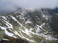
The day dawned with blue skies over northern New Hampshire, but the forecast was for increasing clouds, with showers to move in afternoon, and steadier rain Saturday night. A cloudbank was visible in the east, headed our way from Maine. I planned to ski early, and get down the mountain ahead of the approaching weather. I was at the summit by 9AM, at the top of Airplane by 10, and skied to the bottom by 10:30. During this time, the sky went from mostly to partly sunny, then occasional sunny breaks, followed by solid overcast.
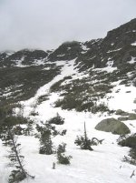
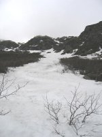
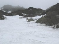
I was able to ski to a short distance above Spaulding Lake, as far as we were able to ski on April 17 (1125' vertical). There was still really good snow cover in Airplane. The surface was 2"-3" of corn on a firm base, just perfect for skiing down (but a little too firm for hiking up without crampons - I was glad I had mine). The bottom couple hundred feet of the runout towards the Lake are getting brushy, but should hold up until the next warm rain storm.
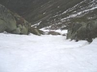
Pipeline looks no longer skiable. There are multiple long breaks in the snow cover, most noticeably 200' below the top and at the bottom icefall.
I hiked back up Airplane by 11:30AM. The first two Cog railway trains passed me as I was hiking back up the Gulfside Trail towards the Auto Road, just before Noon. Just after Noon, I reached the East Snowfields.
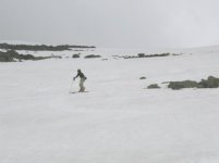
I think I was the only soul who skied Great Gulf yesterday, but I did find 3 other skiers on the East Snowfields. As the first skier skinned to the top of the slope, I was surprised to see that it was a friend of mine. He had hiked up Lions Head at 7AM Saturday morning, and had just finished 4 runs on the snowfields.
Behind him were two more skiers hiking up. Those two tele skiers had paid $24 each to ride the shuttle van to the summit. They had skied the east snowfields several runs, and were about to traverse back towards Tucks, to descend via Left Gully.
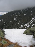
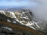
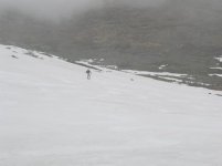
I skied two runs on the East Snowfields, then waited for my friend to take three more. By 1:15PM, the cloud ceiling had lowered, and shrouded the summit in clouds. The fog turned to snow flurries, and my friend continued to ski in the snow, racking up more vertical. Visibility dropped to about thirty feet at one point, and I started to get anxious to get off the summit. But the cloud ceiling lifted slightly by 2PM, and the fog and flurries cleared enough to see Lions Head and the Bowl below us as we traversed the East Snowfields towards Tuckerman Junction. We skied as far towards Boot Spur as we could, following the last finger of snow in that direction, above the center headwall.
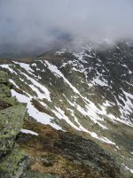
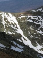
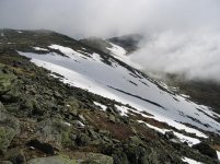
We hiked from there, partly on- and partly off-trail to the top of Hillmans Highway. Our thought was that Hillmans is a longer ski run than Left Gully, and a shorter hike down. My friend had skied Hillmans from the top a week ago.
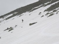
We were disappointed to find the snow at the top had melted away since the previous weekend. We had an 'exciting' hike down 200 vertical feet over loose, slippery rocks in our ski boots to get to the top of the snow. Though the very top has melted out, there are still about 1000' vertical of good skiing to be had in Hillmans. The good snow started just above the (climber's) right-hand fork. I really enjoyed skiing down through the rock-walled section; that's always been my favorite part of Hillmans! There was a 20'-30' brushy section just above the (right-) fork; I was able to side-step and traverse out of it through some brush on skiers right; others were taking their skis off to hike down a few steps on skiers left. Below the fork, it opens up into a wide slope. A nice, advanced-intermediate run, it was bumped up slightly in a few lines.
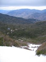
The bottom is an open brook, which luckily was not flowing fast. I easily got down by scrambling on the rocks in the streambed. Then I hiked back to HoJos, and sat on the deck from 3:30 to 5 PM. My friend skied three runs on Hillmans, fulfilling his goal that day of 10,000+ vertical feet skied. I skied roughly one third that. We got down to the his car at Pinkham by 6PM, and did not encounter any sign of rain all day, until a little drizzle fell about 6:15PM.
On the Auto Road yesterday (Saturday, May 21), private vehicles were not allowed past the 4 mile mark. The shuttle "coach" vans were running to the summit, and the Cog was running to the summit, so the State Park building was open.
The day dawned with blue skies over northern New Hampshire, but the forecast was for increasing clouds, with showers to move in afternoon, and steadier rain Saturday night. A cloudbank was visible in the east, headed our way from Maine. I planned to ski early, and get down the mountain ahead of the approaching weather. I was at the summit by 9AM, at the top of Airplane by 10, and skied to the bottom by 10:30. During this time, the sky went from mostly to partly sunny, then occasional sunny breaks, followed by solid overcast.
I was able to ski to a short distance above Spaulding Lake, as far as we were able to ski on April 17 (1125' vertical). There was still really good snow cover in Airplane. The surface was 2"-3" of corn on a firm base, just perfect for skiing down (but a little too firm for hiking up without crampons - I was glad I had mine). The bottom couple hundred feet of the runout towards the Lake are getting brushy, but should hold up until the next warm rain storm.
Pipeline looks no longer skiable. There are multiple long breaks in the snow cover, most noticeably 200' below the top and at the bottom icefall.
I hiked back up Airplane by 11:30AM. The first two Cog railway trains passed me as I was hiking back up the Gulfside Trail towards the Auto Road, just before Noon. Just after Noon, I reached the East Snowfields.
I think I was the only soul who skied Great Gulf yesterday, but I did find 3 other skiers on the East Snowfields. As the first skier skinned to the top of the slope, I was surprised to see that it was a friend of mine. He had hiked up Lions Head at 7AM Saturday morning, and had just finished 4 runs on the snowfields.
Behind him were two more skiers hiking up. Those two tele skiers had paid $24 each to ride the shuttle van to the summit. They had skied the east snowfields several runs, and were about to traverse back towards Tucks, to descend via Left Gully.
I skied two runs on the East Snowfields, then waited for my friend to take three more. By 1:15PM, the cloud ceiling had lowered, and shrouded the summit in clouds. The fog turned to snow flurries, and my friend continued to ski in the snow, racking up more vertical. Visibility dropped to about thirty feet at one point, and I started to get anxious to get off the summit. But the cloud ceiling lifted slightly by 2PM, and the fog and flurries cleared enough to see Lions Head and the Bowl below us as we traversed the East Snowfields towards Tuckerman Junction. We skied as far towards Boot Spur as we could, following the last finger of snow in that direction, above the center headwall.
We hiked from there, partly on- and partly off-trail to the top of Hillmans Highway. Our thought was that Hillmans is a longer ski run than Left Gully, and a shorter hike down. My friend had skied Hillmans from the top a week ago.
We were disappointed to find the snow at the top had melted away since the previous weekend. We had an 'exciting' hike down 200 vertical feet over loose, slippery rocks in our ski boots to get to the top of the snow. Though the very top has melted out, there are still about 1000' vertical of good skiing to be had in Hillmans. The good snow started just above the (climber's) right-hand fork. I really enjoyed skiing down through the rock-walled section; that's always been my favorite part of Hillmans! There was a 20'-30' brushy section just above the (right-) fork; I was able to side-step and traverse out of it through some brush on skiers right; others were taking their skis off to hike down a few steps on skiers left. Below the fork, it opens up into a wide slope. A nice, advanced-intermediate run, it was bumped up slightly in a few lines.
The bottom is an open brook, which luckily was not flowing fast. I easily got down by scrambling on the rocks in the streambed. Then I hiked back to HoJos, and sat on the deck from 3:30 to 5 PM. My friend skied three runs on Hillmans, fulfilling his goal that day of 10,000+ vertical feet skied. I skied roughly one third that. We got down to the his car at Pinkham by 6PM, and did not encounter any sign of rain all day, until a little drizzle fell about 6:15PM.