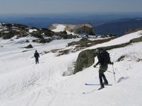
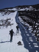
Left the Marshfield Base Station at 9:15 AM, planning a quick, direct route up the Cog RR. Unfortunately, the Cog RR recently shut down ski train operations for the season, and used the blade on a snowcat to bulldoze snow off the ski slope, away from the tracks. Apparently snow melt and rain runoff had been running down along the Cog tracks, and washing out the supports for the track. They had built some water bars, and apparently pushed the snow away from the tracks to prevent more damage. This made skinning up (or skiing down) to the waumbek Tank a poor proposition. We were able to find snow cover in the trees to climbers right most of the way. Note the snow banks over Gary and Dee's shoulder in the photo at the Tank. Above the Tank, they had run the snowblower attachment on the Cog train and left very little snow cover on the tracks. The snow off the sides of the tracks was narrow, but we were able to skin up without too much difficulty. The snow was too crunchy above Jacobs Ladder to skin the last 500+ vertical feet, so we hiked the rest of the way. After seeing it first-hand, we decided not to descend via the Cog.
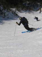
We ran into three of Cannon Mountain's best skiers at the top of Airplane Gully, who had just completed two runs. Sure enough, while we slept in, these guys were at the trailhead, and were getting first tracks while we still lumbered up the mountain. Their advice was that skiers left was nice and soft about half of the way down. To the skiers right had not had enough hours of sun, and the lower elevations were too exposed to the wind to soften up. We skied 625 vertical feet, a little more than halfway down to Spaulding Lake, and stopped where our friends had. There was a nice little moat under a rock to skiers left, were we took off our skis, and ascended back up the nice boot track they had left on climbers right (thanks, Irv, Brian, and Alan!).
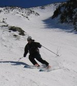
We then decided to hike across the western slope of the summit cone to Lakes of the Clouds, and descend via Monroe Brook, as our friends had done an hour earlier. Skiing across the Westside Trail was a nice surprise. After a short hike up from Clay Col, there was enough snowcover that we were able to traverse the western slope on skis, occasionally sidestepping across a few rocks. It was scratchy, hard surfaces, that hadn't softened, but skiable.
At 3PM, we caught up with our Cannon friends at Lakes.
From Lakes, we descended across icy scratchy hard surfaces. Near the top of Monroe Brook, it had softened enough on the skiers right to be really enjoyable. The descent down MB was really nice. Once down in the brook bed, at lower elevations, there were some open water holes. It looks like a bad day of heavy rain could wash out much of this lower section, making the connection to Ammonoosuc Ravine Trail impassable. Watch the weather, we may get another weekend or two of MB, if we're lucky.
We ran into three of Cannon Mountain's best skiers at the top of Airplane Gully, who had just completed two runs. Sure enough, while we slept in, these guys were at the trailhead, and were getting first tracks while we still lumbered up the mountain. Their advice was that skiers left was nice and soft about half of the way down. To the skiers right had not had enough hours of sun, and the lower elevations were too exposed to the wind to soften up. We skied 625 vertical feet, a little more than halfway down to Spaulding Lake, and stopped where our friends had. There was a nice little moat under a rock to skiers left, were we took off our skis, and ascended back up the nice boot track they had left on climbers right (thanks, Irv, Brian, and Alan!).
We then decided to hike across the western slope of the summit cone to Lakes of the Clouds, and descend via Monroe Brook, as our friends had done an hour earlier. Skiing across the Westside Trail was a nice surprise. After a short hike up from Clay Col, there was enough snowcover that we were able to traverse the western slope on skis, occasionally sidestepping across a few rocks. It was scratchy, hard surfaces, that hadn't softened, but skiable.
At 3PM, we caught up with our Cannon friends at Lakes.
From Lakes, we descended across icy scratchy hard surfaces. Near the top of Monroe Brook, it had softened enough on the skiers right to be really enjoyable. The descent down MB was really nice. Once down in the brook bed, at lower elevations, there were some open water holes. It looks like a bad day of heavy rain could wash out much of this lower section, making the connection to Ammonoosuc Ravine Trail impassable. Watch the weather, we may get another weekend or two of MB, if we're lucky.