J.Spin
New member
Links to additional pictures from the day are available at the bottom of the report.
The "Easter Snowstorm" wound down by Tuesday, April 10th in our area, and after a short interlude, the next big spring snowstorm was on our doorstep. The prospect of another potentially big snowstorm was pretty exciting, certainly because of the skiing of course, but also because we were getting close to 150 inches of snow accumulation for the season in Waterbury. After passing 100 inches of snowfall accumulation on March 2nd, 150 inches was the next milestone I'd been wondering about. There was certainly going to be plenty of moisture with the upcoming storm; the big question was how warm the temperatures were going to be for the valleys. Would the snow level dip low enough for us to pick up substantial accumulating snow? For Waterbury, the snowfall from the storm began on Friday morning, and about an hour after the snow started falling, I took my first snowfall measurement for the event:
Thursday, April 12th, 2007: 8:00 A.M. update from Waterbury, VT.
New snow since previous measurement: 0.8 inches
Temperature: 33.6 F
Humidity 89%
Wind: Calm
Sky: Snow
Cumulative storm total: 0.8 inches
Current snow at stake: 13 inches
Season snowfall total: 145.3 inches
"I noticed that it has started snowing here at 7:07 A.M. just as I was listening to Mark Breen talk about the storm in his morning Eye on the Sky report for Vermont Public Radio. I'd been checking out the window every couple of minutes because the radar suggested the snowfall was right on our doorstep. The snow looked to be coming down fairly intensely for that first hour, apparently around an inch an hour based on the 8:00 A.M. accumulation. Prior to this snow, the snowpack in the yard had melted out to a point just shy of where it had reached before the last storm (~25% coverage), but there was still 13 inches in the sheltered area at the backyard stake. The new accumulation on the snowboard was rather wet, clumping together in sticky sheets as I cleared it off the snowboard, but there wasn't any obvious melting or free water. I'd estimate the water content of the snow at somewhere around 12% H2O down at this elevation with the temperature a bit above freezing."
In the deeper valleys, the temperatures remained above freezing during the day, but we still managed to pick up some accumulating snow on the snowboard in Waterbury.
Thursday, April 12th, 2007: 6:00 P.M. update from Waterbury, VT.
New snow since previous measurement: 2.6 inches
Temperature: 34.5 F
Humidity 95%
Wind: 0-5 MPH
Sky: Light snow
Cumulative storm total: 3.4 inches
Current snow at stake: 15 inches
Season snowfall total: 147.9 inches
"It was interesting noting the snowfall accumulations on the drive home to Waterbury from Burlington. We saw some pretty heavy snowfall in Burlington in the afternoon, and when I left there at around 5:30 P.M. there were a couple of inches of wet accumulation at my location (elevation 380') and the temperature was 37 F. The temperature remained around 37 F, but the snow accumulation started to fade as I headed toward Richmond, and at the Richmond exit of I-89 (elevation 300') there was just grass and no accumulation of snow. I don't think the slight elevation change had anything to do with the lack of snow because the snowfall was disappearing even as I passed through the high point of I-89 (elevation 620') in the Williston area. The snowfall just seemed to miss the area around the Richmond interchange, or perhaps the temperature was just warm enough during the day to prevent any accumulation. By the time I got to the actual center of Richmond there was a dusting of accumulation. The temperature gradually dropped as I headed toward Waterbury and the accumulation of new snow increased until I stopped at our house where there were an additional 2.6 inches of new snow on the snowboard, and the temperature was 34.5 F. That accumulation brought us to 3.4 inches from this event so far. It's been snowing lightly here since the 6:00 P.M. reading and there's probably another ½ inch of snow on the snowboard, but I'll probably have to take the next reading in the morning to find out where we're at for this storm."
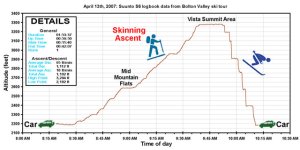
That night we got some additional snow and finally edged past the 150-inch mark for the season's accumulation. In the morning, I took some weather observations before heading up to Bolton for some skiing on the way to work.
Friday, April 13th, 2007: 7:00 A.M. update from Waterbury, VT.
New snow since previous measurement: 2.2 inches
Temperature: 32.9 F
Humidity 98%
Wind: Calm
Sky: Light snow
Cumulative storm total: 5.6 inches
Current snow at stake: 18 inches
Season snowfall total: 150.1 inches
"We picked up another 2.2 inches of snow overnight, which pushed us past the 150-inch accumulation mark for the season."
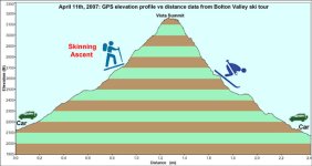
As I made my trip up to Bolton's slopes, I observed just an inch or two of total snow on the ground at the base of the Bolton Valley access road (elevation ~340'). But, there were around 7-9 new inches of new snow up at the village (elevation ~2,150') on top of what was becoming a very substantial base. I skinned up my usual route using Sprig O' Pine to get to Mid Mountain, and was able to use a snowmobile track up to that point to avoid breaking trail. It was snowing moderately, and despite the temperature being very close to freezing, the snow was reasonably dry. I'd put the snow somewhere in the 10% H2O range for density. Unfortunately, the hydrological measurements for Jay Peak and the Mt. Mansfield stake were all over the map for that timeframe (ranging from 4% to 21% H2O) so they weren't much help in confirming my snow density estimate with any sort of trend. However, the Mt. Mansfield stake was at least helpful in indicating the change in the mountain snowpack over the previous couple of weeks. The stake was reading 85 inches as of Thursday evening, after being at only 60 inches near the beginning of the month.
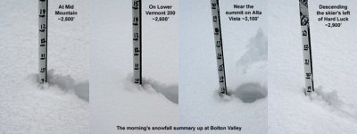
Upon reaching Mid Mountain (elevation ~2,500'), I checked the depth of the new snow with my measuring ski pole and found it to be around 9 inches. The snowmobile track ended at Mid Mountain, so from that point I started following a skin track that headed to the upper mountain. Thanks go out to whoever broke trail up there. Just below the first steep pitch of Lower Vermont 200, the skin track diverged into two. The left track headed straight up the steep pitch, while the right track took a more gradual slope and headed off in the direction of the Vista Quad lift line. I've used that route to skin around the steep section of Lower Vermont 200 in the past, so I took that one. The right skin track actually continued to head off more toward the lift line, so I had to break a little trail in order to get back on my desired route. I soon rejoined the other (left) skin track, and after taking a look at its path, I decided that the pitch of Lower Vermont 200 that I've often circumvented in the past is actually pretty reasonable for skinning, depending on the type of snow on the ground. I made a mental note to try that potentially more efficient route in the future. I took another measurement of the new snow in that area (elevation 2,600'), and found that it was up to 10 inches.
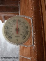
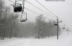
I again opted to work my way up the rather steep Schuss trail with some switchbacks, and then used Alta Vista for the final leg to the summit. I took another snow measurement on Alta Vista (elevation ~3,100') and found that the depth of the new snow was up to 13 inches. It was still snowing moderately, and when I ascended further and left the protection of the trees, I got a taste of the strong wind in the summit area. I tucked myself behind the upper station of the Vista Quad so that I was out of the wind, removed my skins from my skis, and had a snack. The thermometer at the lift station was reading between 30 and 31 degrees F at the time I was up there, so it didn't seem like there was too much room for the temperature to move if it was going to stay below freezing. I was wondering what temperatures and snow conditions I'd find 1,000 feet below near the base area.
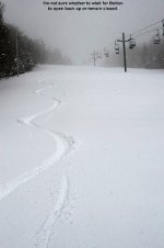
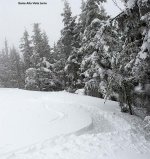
For the descent, I headed back down Alta Vista since I knew there was some wind-protected snow along the skier's left. Just as I was starting down, a man on snowshoes was cresting the summit, and we chatted for a moment about the great snow. The snow I found on Alta Vista certainly didn't disappoint, but it became even better as I connected onto Hard Luck. The powder there was feeling surprisingly deep, so I took another depth measurement there at around 2,900' and found a whopping 19 inches of loose snow. The skier's left of Hard Luck really seems to have a combination of elevation and aspect that collects snow very well. Below Mid Mountain, I opted for skiing Beech Seal, and put down the lone powder signature there. The Avocet recorded a descent of 1,095 vertical feet, while the Suunto recorded a descent of 1,112 vertical feet for a difference of 1.5%. Although the temperature so close to the freezing mark at the summit had concerned me about the snow I'd find near the base on my descent, the snow had stayed relatively light and dry in the entire elevation range that I skied.
It had snowed moderately for my entire outing at the resort, and it didn't show any signs of stopping when I left. As I headed to work, the snow mixed with rain as I descended in elevation on the access road, and then changed over to all rain by the time I hit the Richmond area. It rained in Burlington during the day and eventually it changed back over to snow in the afternoon, but there were still just a couple of inches of wet snow on the ground. When I finally got home later that evening, I took a reading off the snowboard and put together some weather observations from the day:
Friday, April 13th, 2007: 10:00 P.M. update from Waterbury, VT.
New snow since previous measurement: 0.2 inches
Temperature: 33.8 F
Humidity 98%
Wind: Calm
Sky: Light snow
Cumulative storm total: 5.8 inches
Current snow at stake: 16 inches
Season snowfall total: 150.3 inches
"Around 9:00 P.M., we headed home to Waterbury from the Burlington area where the temperature was 36 F. The precipitation was generally rain for most of the route home, with just a bit of snow mixing in. The temperature dropped to 35 as we hit the high point along I-89 in Williston, and stayed that way for a while. Snow mixed in more as we hit the Bolton area, and it was all snow by the time we got to the house. We haven't really been shoveling the driveway through these last rounds of snow, because the days have been warm enough that a lot of it melts. Well, that policy caught up with us tonight and we had to do a little pushing to get the Mazda up the driveway. Even the Subaru struggled a little. We'll often drive up through 6 inches of more of snow, and the typical powdery stuff we get isn't much of a hindrance. However the snow out there right now is really wet. Even though there were only about 4 inches in the driveway, it was so thick and saturated with water that the cars had a hard time pushing through it. So, I finally broke down and decided to give the driveway a shoveling. It actually wasn't too bad because I was able to just push the snow to the sides. Lifting shovelfuls of that stuff is tough anyway, so the pushing was nice. On the snowboard there was just a slushy 0.2 inches of accumulation, which had probably accumulated in the evening as the temperature started to fall. It snowed for a while after the reading to produce another 0.1 inch of accumulation, but it has been going back and forth between rain and snow. Maybe we'll get a little more accumulation of the temperature drops."
The snow continued on in the mountains, but down in Waterbury we had a mix of rain and snow with temperatures above freezing, so we received no additional accumulation from that event. That April 13th and 14th storm was our 36th valley snowfall event of the season. It delivered a total of 5.8 inches of snow, and was tied with the March 4th snowfall event for the 9th largest of the season at our location.
Additional pictures associated with the report can be found at the temporary link below, or the permanent link when the temporary link stops working:
http://www.uvm.edu/~jsilveir/2007/13APR07.html
If the temporary link is no longer available, try the permanent link:
http://www.jandeproductions.com/2007/13APR07.html
J.Spin
The "Easter Snowstorm" wound down by Tuesday, April 10th in our area, and after a short interlude, the next big spring snowstorm was on our doorstep. The prospect of another potentially big snowstorm was pretty exciting, certainly because of the skiing of course, but also because we were getting close to 150 inches of snow accumulation for the season in Waterbury. After passing 100 inches of snowfall accumulation on March 2nd, 150 inches was the next milestone I'd been wondering about. There was certainly going to be plenty of moisture with the upcoming storm; the big question was how warm the temperatures were going to be for the valleys. Would the snow level dip low enough for us to pick up substantial accumulating snow? For Waterbury, the snowfall from the storm began on Friday morning, and about an hour after the snow started falling, I took my first snowfall measurement for the event:
Thursday, April 12th, 2007: 8:00 A.M. update from Waterbury, VT.
New snow since previous measurement: 0.8 inches
Temperature: 33.6 F
Humidity 89%
Wind: Calm
Sky: Snow
Cumulative storm total: 0.8 inches
Current snow at stake: 13 inches
Season snowfall total: 145.3 inches
"I noticed that it has started snowing here at 7:07 A.M. just as I was listening to Mark Breen talk about the storm in his morning Eye on the Sky report for Vermont Public Radio. I'd been checking out the window every couple of minutes because the radar suggested the snowfall was right on our doorstep. The snow looked to be coming down fairly intensely for that first hour, apparently around an inch an hour based on the 8:00 A.M. accumulation. Prior to this snow, the snowpack in the yard had melted out to a point just shy of where it had reached before the last storm (~25% coverage), but there was still 13 inches in the sheltered area at the backyard stake. The new accumulation on the snowboard was rather wet, clumping together in sticky sheets as I cleared it off the snowboard, but there wasn't any obvious melting or free water. I'd estimate the water content of the snow at somewhere around 12% H2O down at this elevation with the temperature a bit above freezing."
In the deeper valleys, the temperatures remained above freezing during the day, but we still managed to pick up some accumulating snow on the snowboard in Waterbury.
Thursday, April 12th, 2007: 6:00 P.M. update from Waterbury, VT.
New snow since previous measurement: 2.6 inches
Temperature: 34.5 F
Humidity 95%
Wind: 0-5 MPH
Sky: Light snow
Cumulative storm total: 3.4 inches
Current snow at stake: 15 inches
Season snowfall total: 147.9 inches
"It was interesting noting the snowfall accumulations on the drive home to Waterbury from Burlington. We saw some pretty heavy snowfall in Burlington in the afternoon, and when I left there at around 5:30 P.M. there were a couple of inches of wet accumulation at my location (elevation 380') and the temperature was 37 F. The temperature remained around 37 F, but the snow accumulation started to fade as I headed toward Richmond, and at the Richmond exit of I-89 (elevation 300') there was just grass and no accumulation of snow. I don't think the slight elevation change had anything to do with the lack of snow because the snowfall was disappearing even as I passed through the high point of I-89 (elevation 620') in the Williston area. The snowfall just seemed to miss the area around the Richmond interchange, or perhaps the temperature was just warm enough during the day to prevent any accumulation. By the time I got to the actual center of Richmond there was a dusting of accumulation. The temperature gradually dropped as I headed toward Waterbury and the accumulation of new snow increased until I stopped at our house where there were an additional 2.6 inches of new snow on the snowboard, and the temperature was 34.5 F. That accumulation brought us to 3.4 inches from this event so far. It's been snowing lightly here since the 6:00 P.M. reading and there's probably another ½ inch of snow on the snowboard, but I'll probably have to take the next reading in the morning to find out where we're at for this storm."
That night we got some additional snow and finally edged past the 150-inch mark for the season's accumulation. In the morning, I took some weather observations before heading up to Bolton for some skiing on the way to work.
Friday, April 13th, 2007: 7:00 A.M. update from Waterbury, VT.
New snow since previous measurement: 2.2 inches
Temperature: 32.9 F
Humidity 98%
Wind: Calm
Sky: Light snow
Cumulative storm total: 5.6 inches
Current snow at stake: 18 inches
Season snowfall total: 150.1 inches
"We picked up another 2.2 inches of snow overnight, which pushed us past the 150-inch accumulation mark for the season."
As I made my trip up to Bolton's slopes, I observed just an inch or two of total snow on the ground at the base of the Bolton Valley access road (elevation ~340'). But, there were around 7-9 new inches of new snow up at the village (elevation ~2,150') on top of what was becoming a very substantial base. I skinned up my usual route using Sprig O' Pine to get to Mid Mountain, and was able to use a snowmobile track up to that point to avoid breaking trail. It was snowing moderately, and despite the temperature being very close to freezing, the snow was reasonably dry. I'd put the snow somewhere in the 10% H2O range for density. Unfortunately, the hydrological measurements for Jay Peak and the Mt. Mansfield stake were all over the map for that timeframe (ranging from 4% to 21% H2O) so they weren't much help in confirming my snow density estimate with any sort of trend. However, the Mt. Mansfield stake was at least helpful in indicating the change in the mountain snowpack over the previous couple of weeks. The stake was reading 85 inches as of Thursday evening, after being at only 60 inches near the beginning of the month.
Upon reaching Mid Mountain (elevation ~2,500'), I checked the depth of the new snow with my measuring ski pole and found it to be around 9 inches. The snowmobile track ended at Mid Mountain, so from that point I started following a skin track that headed to the upper mountain. Thanks go out to whoever broke trail up there. Just below the first steep pitch of Lower Vermont 200, the skin track diverged into two. The left track headed straight up the steep pitch, while the right track took a more gradual slope and headed off in the direction of the Vista Quad lift line. I've used that route to skin around the steep section of Lower Vermont 200 in the past, so I took that one. The right skin track actually continued to head off more toward the lift line, so I had to break a little trail in order to get back on my desired route. I soon rejoined the other (left) skin track, and after taking a look at its path, I decided that the pitch of Lower Vermont 200 that I've often circumvented in the past is actually pretty reasonable for skinning, depending on the type of snow on the ground. I made a mental note to try that potentially more efficient route in the future. I took another measurement of the new snow in that area (elevation 2,600'), and found that it was up to 10 inches.
I again opted to work my way up the rather steep Schuss trail with some switchbacks, and then used Alta Vista for the final leg to the summit. I took another snow measurement on Alta Vista (elevation ~3,100') and found that the depth of the new snow was up to 13 inches. It was still snowing moderately, and when I ascended further and left the protection of the trees, I got a taste of the strong wind in the summit area. I tucked myself behind the upper station of the Vista Quad so that I was out of the wind, removed my skins from my skis, and had a snack. The thermometer at the lift station was reading between 30 and 31 degrees F at the time I was up there, so it didn't seem like there was too much room for the temperature to move if it was going to stay below freezing. I was wondering what temperatures and snow conditions I'd find 1,000 feet below near the base area.
For the descent, I headed back down Alta Vista since I knew there was some wind-protected snow along the skier's left. Just as I was starting down, a man on snowshoes was cresting the summit, and we chatted for a moment about the great snow. The snow I found on Alta Vista certainly didn't disappoint, but it became even better as I connected onto Hard Luck. The powder there was feeling surprisingly deep, so I took another depth measurement there at around 2,900' and found a whopping 19 inches of loose snow. The skier's left of Hard Luck really seems to have a combination of elevation and aspect that collects snow very well. Below Mid Mountain, I opted for skiing Beech Seal, and put down the lone powder signature there. The Avocet recorded a descent of 1,095 vertical feet, while the Suunto recorded a descent of 1,112 vertical feet for a difference of 1.5%. Although the temperature so close to the freezing mark at the summit had concerned me about the snow I'd find near the base on my descent, the snow had stayed relatively light and dry in the entire elevation range that I skied.
It had snowed moderately for my entire outing at the resort, and it didn't show any signs of stopping when I left. As I headed to work, the snow mixed with rain as I descended in elevation on the access road, and then changed over to all rain by the time I hit the Richmond area. It rained in Burlington during the day and eventually it changed back over to snow in the afternoon, but there were still just a couple of inches of wet snow on the ground. When I finally got home later that evening, I took a reading off the snowboard and put together some weather observations from the day:
Friday, April 13th, 2007: 10:00 P.M. update from Waterbury, VT.
New snow since previous measurement: 0.2 inches
Temperature: 33.8 F
Humidity 98%
Wind: Calm
Sky: Light snow
Cumulative storm total: 5.8 inches
Current snow at stake: 16 inches
Season snowfall total: 150.3 inches
"Around 9:00 P.M., we headed home to Waterbury from the Burlington area where the temperature was 36 F. The precipitation was generally rain for most of the route home, with just a bit of snow mixing in. The temperature dropped to 35 as we hit the high point along I-89 in Williston, and stayed that way for a while. Snow mixed in more as we hit the Bolton area, and it was all snow by the time we got to the house. We haven't really been shoveling the driveway through these last rounds of snow, because the days have been warm enough that a lot of it melts. Well, that policy caught up with us tonight and we had to do a little pushing to get the Mazda up the driveway. Even the Subaru struggled a little. We'll often drive up through 6 inches of more of snow, and the typical powdery stuff we get isn't much of a hindrance. However the snow out there right now is really wet. Even though there were only about 4 inches in the driveway, it was so thick and saturated with water that the cars had a hard time pushing through it. So, I finally broke down and decided to give the driveway a shoveling. It actually wasn't too bad because I was able to just push the snow to the sides. Lifting shovelfuls of that stuff is tough anyway, so the pushing was nice. On the snowboard there was just a slushy 0.2 inches of accumulation, which had probably accumulated in the evening as the temperature started to fall. It snowed for a while after the reading to produce another 0.1 inch of accumulation, but it has been going back and forth between rain and snow. Maybe we'll get a little more accumulation of the temperature drops."
The snow continued on in the mountains, but down in Waterbury we had a mix of rain and snow with temperatures above freezing, so we received no additional accumulation from that event. That April 13th and 14th storm was our 36th valley snowfall event of the season. It delivered a total of 5.8 inches of snow, and was tied with the March 4th snowfall event for the 9th largest of the season at our location.
Additional pictures associated with the report can be found at the temporary link below, or the permanent link when the temporary link stops working:
http://www.uvm.edu/~jsilveir/2007/13APR07.html
If the temporary link is no longer available, try the permanent link:
http://www.jandeproductions.com/2007/13APR07.html
J.Spin