There were a couple of hikes I wanted to get in before I left SoCal at the end of May.
The Angeles Crest Hwy was still closed at Islip Saddle on May 20. The snow is long gone, but it takes longer to clear rockslides. It opened to Vincent Gap/Big Pines sometime in June. I followed the Pacific Crest Trail east like the two backcountry skiers I met here on April 18.

Eventually I reached this view east of the closed part of the Angeles Crest below, and also at left distance where it rises to its max elevation of 7,900 feet at Dawson Saddle.

The high point is near 9,100 foot Throop Peak where I took Samantha in 2009. Note zero snow at 9,000 when it was skiable to 7,000 a month earlier.
I was soon on the wider dirt road to Little Jimmy Camp, which provides closer access when the Angeles Crest is fully open. I shortcut right off that road and soon reached the more direct trail to Mt. Islip. That trail ascends a ridgeline on the east side of the peak, providing the best view of the upper San Gabriel River drainage.

Crystal Lake is at right. The San Gabriel Reservoir is at far distance.
Stone hut on top of 8,250 foot Mt. Islip:

View west to Mt. Waterman’s upper easier trails:

Elevations are similar, but views from Islip are better as it’s a sharper and more exposed peak with less vegetation.
Desert view north:

From the top of Islip the remnants of snow at Baldy’s 10,068 foot peak are barely visible.

Round trip was a bit over 3 hours with 1,570 elevation gain. Midweek I encountered less than 10 other people.
My May 22 hike started at the very popular Chantry Flat area above Arcadia. There was a sign in Arcadia warning that there was no parking, but I figured correctly that arriving at 3PM I would catch someone leaving.
As I walked from the lower to upper parking area I noticed a group of people who were watching this bear hanging out near some dumpsters.

I hiked a loop of the Upper Winter Creek Trail to the Lower Winter Creek Trail.

Most visitors to Chantry Flat hike down to the Santa Anita Wash, then down to Hermit Falls or up to Sturtevant Falls.
It’s only 2,150 feet here, which usually means a hot hike this time of year in SoCal aside from near the beach areas. But both Winter Creek Trails are almost continuously shaded, and the lush vegetation here is rarely seen in the Verdugo Mountains above my house.

The greenery has lasted longer this spring even in less sheltered areas due to the 3-5 inches of rain during Easter Week.
During a rare break in the vegetation I get a view down to the Chantry Flat parking and Santa Anita Canyon. This is probably near the upper trail high point at 2,900 feet.

This was my objective, prompted by Larry Schick’s research on extreme rain/flood events.

The sign is on fairly high ground just north of Winter Creek at 2,500 feet.
There was no trace of any structure near the sign, but this stone foundation was just after I crossed Winter Creek to the south.

There are campsites and picnic tables nearby.

Lower Winter Creek Trail with one of at least 12 “Lincoln Log” dams on Winter Creek.

Winter Creek runs straight off the east side of 5,700 foot Mt. Wilson and flood potential is obvious even if you didn’t know about January 1943. The tree canopy was dense enough that I never got a clear view of Mt. Wilson.
Lower down I was surprised to see several private cabins.


These are similar to those in Icehouse Canyon above Mt. Baldy Village.
Here water is seeping through the gaps in the “Lincoln Logs.”

Perhaps this is by design for flood events.
A lower dam:

The lower Winter Creek Trail ends at 1,800 feet, where it meets a paved trail back to Chantry Flats. This is the one section where you will get hot, and it’s recommended that dogs avoid it in summer. It was still warm at 6PM but this blue jay stopped here anyway.

The demise of Hoegee’s Camp in 1953 is worthy of note. For those who think that destructive SoCal fires are a recent phenomenon or that it’s unusual when they occur as late as the Dec. 5 start of the Thomas Fire in 2017, the Monrovia Peak Fire lasted from Dec. 27, 1953 to Jan. 2, 1954 and must have been quite a sight from the 1954 Rose Parade.

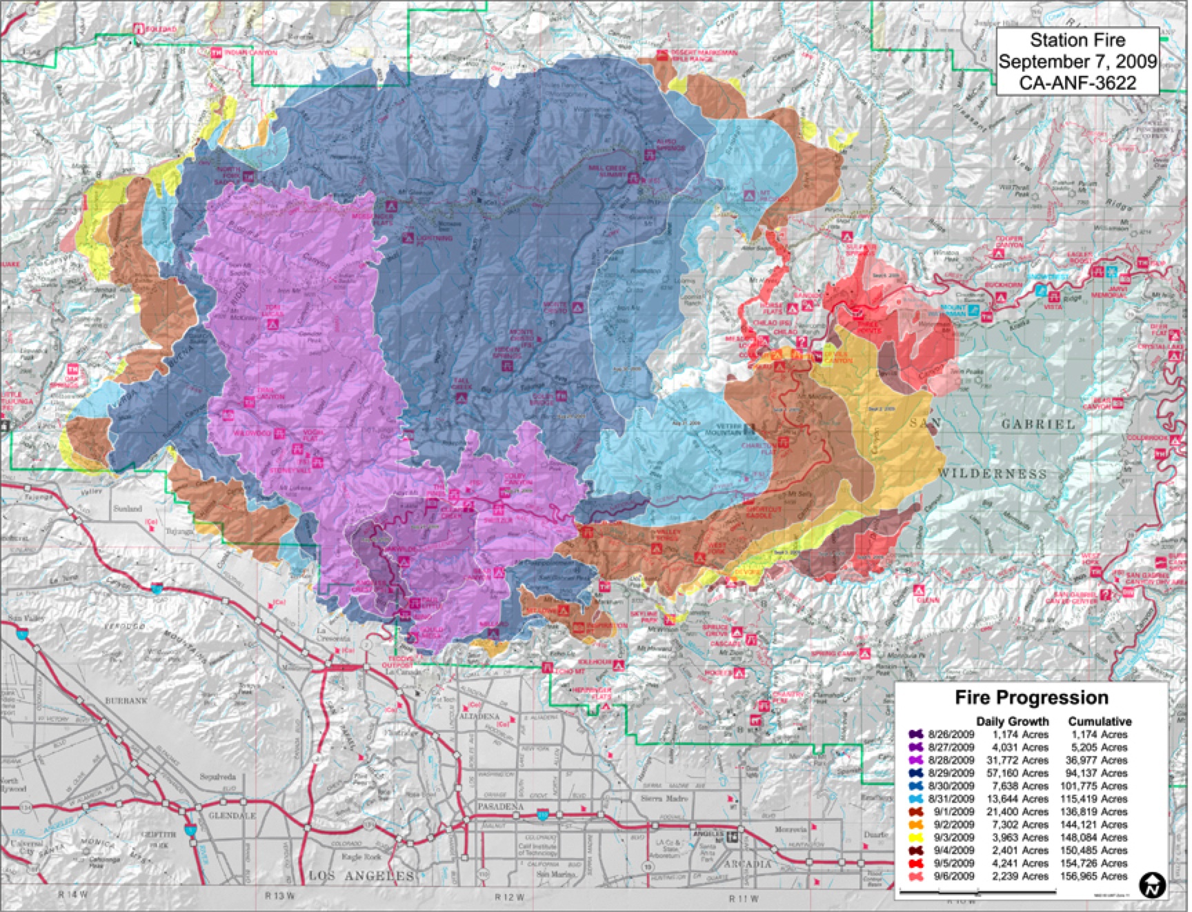
This was probably the closest ever fire threat to the Mt. Wilson Observatory. The 2009 Station Fire burned 10x as much acreage but was kept much farther from Mt. Wilson.
The Angeles Crest Hwy was still closed at Islip Saddle on May 20. The snow is long gone, but it takes longer to clear rockslides. It opened to Vincent Gap/Big Pines sometime in June. I followed the Pacific Crest Trail east like the two backcountry skiers I met here on April 18.
Eventually I reached this view east of the closed part of the Angeles Crest below, and also at left distance where it rises to its max elevation of 7,900 feet at Dawson Saddle.
The high point is near 9,100 foot Throop Peak where I took Samantha in 2009. Note zero snow at 9,000 when it was skiable to 7,000 a month earlier.
I was soon on the wider dirt road to Little Jimmy Camp, which provides closer access when the Angeles Crest is fully open. I shortcut right off that road and soon reached the more direct trail to Mt. Islip. That trail ascends a ridgeline on the east side of the peak, providing the best view of the upper San Gabriel River drainage.
Crystal Lake is at right. The San Gabriel Reservoir is at far distance.
Stone hut on top of 8,250 foot Mt. Islip:
View west to Mt. Waterman’s upper easier trails:
Elevations are similar, but views from Islip are better as it’s a sharper and more exposed peak with less vegetation.
Desert view north:
From the top of Islip the remnants of snow at Baldy’s 10,068 foot peak are barely visible.
Round trip was a bit over 3 hours with 1,570 elevation gain. Midweek I encountered less than 10 other people.
My May 22 hike started at the very popular Chantry Flat area above Arcadia. There was a sign in Arcadia warning that there was no parking, but I figured correctly that arriving at 3PM I would catch someone leaving.
As I walked from the lower to upper parking area I noticed a group of people who were watching this bear hanging out near some dumpsters.
I hiked a loop of the Upper Winter Creek Trail to the Lower Winter Creek Trail.
Most visitors to Chantry Flat hike down to the Santa Anita Wash, then down to Hermit Falls or up to Sturtevant Falls.
It’s only 2,150 feet here, which usually means a hot hike this time of year in SoCal aside from near the beach areas. But both Winter Creek Trails are almost continuously shaded, and the lush vegetation here is rarely seen in the Verdugo Mountains above my house.
The greenery has lasted longer this spring even in less sheltered areas due to the 3-5 inches of rain during Easter Week.
During a rare break in the vegetation I get a view down to the Chantry Flat parking and Santa Anita Canyon. This is probably near the upper trail high point at 2,900 feet.
This was my objective, prompted by Larry Schick’s research on extreme rain/flood events.
The sign is on fairly high ground just north of Winter Creek at 2,500 feet.
There was no trace of any structure near the sign, but this stone foundation was just after I crossed Winter Creek to the south.
There are campsites and picnic tables nearby.
Lower Winter Creek Trail with one of at least 12 “Lincoln Log” dams on Winter Creek.
Winter Creek runs straight off the east side of 5,700 foot Mt. Wilson and flood potential is obvious even if you didn’t know about January 1943. The tree canopy was dense enough that I never got a clear view of Mt. Wilson.
Lower down I was surprised to see several private cabins.
These are similar to those in Icehouse Canyon above Mt. Baldy Village.
Here water is seeping through the gaps in the “Lincoln Logs.”
Perhaps this is by design for flood events.
A lower dam:
The lower Winter Creek Trail ends at 1,800 feet, where it meets a paved trail back to Chantry Flats. This is the one section where you will get hot, and it’s recommended that dogs avoid it in summer. It was still warm at 6PM but this blue jay stopped here anyway.
The demise of Hoegee’s Camp in 1953 is worthy of note. For those who think that destructive SoCal fires are a recent phenomenon or that it’s unusual when they occur as late as the Dec. 5 start of the Thomas Fire in 2017, the Monrovia Peak Fire lasted from Dec. 27, 1953 to Jan. 2, 1954 and must have been quite a sight from the 1954 Rose Parade.
This was probably the closest ever fire threat to the Mt. Wilson Observatory. The 2009 Station Fire burned 10x as much acreage but was kept much farther from Mt. Wilson.