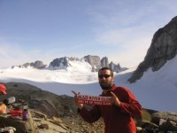
in BC, on the beltway glacier. the alaska border is at the shadow 300 yards in the background. this sat in my pack for 5 weeks before the weather and time was right. this is about 10km south of the Yukon border. had to bring it with me- ski the east!
You are using an out of date browser. It may not display this or other websites correctly.
You should upgrade or use an alternative browser.
You should upgrade or use an alternative browser.
a long way from home, showing MRG colors
- Thread starter ono
- Start date
well, a brief summary-
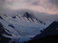
started out june 12th hiking fully loaded- 60 or so pound packs on the kluane plateau west southwest of whitehorse, yukon. started off in the foothills and mountains of the St. Elias range, moving west into the coastal mountains on the BC/AK border. hit glacier about 3.5 weeks in- we entered AK a few times (technically illegal) but who was there to nab us?
we were resupplied by float plane in the lower mountain areas (twice) and helicopter twice- up high in the alpine. it rained ALOT, sleeted some, and snowed a little. pea soup cloudiness alot, too. though we did get a surprising number of sunny days relative to what you'd expect being in the coastal mountains of AK and BC.
did a few summits- Mount Foster is probably the most notable- only because of the fact that the US/Canadian border does a 90 degree turn at the peak. nothing super-high altitude, and only a few technical routes really required snow protection. we were, however, graced with the view of some mammoth mountains- mount fairweather (17,000 ft, with a ton of vertical) is, in particular, a magnificently huge massif.
all in all, we spent 48 or 49 days straight in the backcountry- never once seeing someone outside our group or pilots. well, until the last day out- we crossed over the chilcoot trail, and sitting in a nameless pass 2000ft above the plateau the pass runs over, a random guy walks up. mario was doing a food drop for some guided tour. nice guy, working outta skagway. was a patroller at crystal mountain, WA in the winter.
one last: funny time when we popped out of the mountains, we were at the border crossing near fraser, BC. young guy comes out to ask where we'd been, and if we could prove it. we say "well, we have the maps." as one of us reaches into a pack, praying that he didn't pull out the USGS alaska map. whew- he grabbed the right set. overall, pretty cool time. definitely recommend a trip up for anyone.
one thing to note- our topo maps (dated from the mid 80's mostly) obviously showed us where the glaciers were- but damn, every glacier had retreated ALOT- 1-2km on the average for the big guys, and some pocket glaciers on the map are, in reality, best described as snow patches now. definitely an eye-opener. made obvious topo features not so obvious during observation, too.
Thanks for the report any more pictures to post. Interesting first hand observation on the retreating glaciers. Your western observation is in line with our declining eastern snowfalls, thickness of river/lake ice an overall just warmer temperatures. Keep the fingers crossed for a good season at MRG.
Admin should sign ono up for a feature on this...
I think some pro freeskier like Chris Davenport is contemplating an expedition to Mt. St. Elias, which might have the potentially longest continuous skiable vertical in the world.
Those MRG stickers are ubiquitous in the ski world. I'm sure I've seen them outside North America, but I don't recall specifics.
Larry Schick and I think that area around Mt. Fairweather is a hypothetical candidate for World's Highest Snowfall.
That said, timing of your trip was good. It's fairly well known in the SE Alaska cruise business that the front end of the season (May/June) is much less cloudy/rainy on average than the back end (August/September).
Patrick
Well-known member
The MRG bumpersticker even made it out in space (ie. Space shuttle), however I don't think that where you've seen it before.Tony Crocker":9t09h05z said:Those MRG stickers are ubiquitous in the ski world. I'm sure I've seen them outside North America, but I don't recall specifics.
")
jasoncapecod
Well-known member

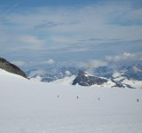
a little different perspective...
got plenty more good ones- waaaay to many to post.
got plenty more good ones- waaaay to many to post.
Attachments


jasoncapecod
Well-known member
p
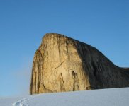
One forty footer is bad enough, but 2 yiks... What kinda of pro did he fall on?eak we call "greyskull" unofficially. it's about 800 vertical face, named after castle greyskull of the Heman comic. four folks tried a technical ascent up the face, and turned back after 2 forty-foot lead climb falls (really, really bad rock to climb!
edit: a little bird tells me greyskull is a 2000 ft vertical face. while i think that's hyped up, it's probably somewhere in between- most likely 1500ft. the little brother of greyskull is around 800ft of vertical rock. my memory fails me.
the pro they fell on- well, i know for a fact that at least one pro placement let go both times- the rock was very fractured from my experience (we setup base camp on a nunatak of the same rock, in its shadown, that was pure crap rock. i don't know specifics- just one of the guys we were with knew the details- i wasn't part of that attempt. yeah, you'd think after one forty footer you'd probably give in, and turn back.
as for turns, nope. we were in that area mid-july. we talked about hitting some of the stuff to the south on the roadtrip home (whitehorse to san diego! 2500 miles!) along the cassiar highway- stikine glacier area was mulled over. but it would be late august then. it was very rainy, and the snow was super variable (high snow year). we didn't have the time or resources ($) or energy (we were pretty beat up after 75 days out!) one knew the area well- once upon a time he was a local to the area of fraser, BC- said may was the best time to ski, and was said to be truly EPIC. thinking over going back sometime in the next few years, however hard that would be to realize.