J.Spin
Member
A link to additonal pictures is available at the bottom of the report.
While skiing at Bolton Valley on Saturday after the nor'easter, E and I discovered that the resort's mainly west-facing slopes had been blasted with strong winds from the storm. Instead of bottomless powder, we found mostly wind-packed surfaces that while challenging and somewhat fun to ski, were certainly not the cream of what this storm had to offer in terms of ski surfaces. The weather since the storm had remained cool, so there had to be some fluffy, wind-sheltered powder sitting out there somewhere; I just needed to choose terrain of the right aspect and elevation to find it. The previous weekend, I had explored the backcountry ski terrain above the V.A.S.T. parking area on the west side of the Bolton Valley Access Road. The snow and terrain there had given me about 1,000 vertical feet of fun powder skiing down from the western ridge of the valley, and the area was also on the leeward side of the prevailing winds. To mix things up a bit and get in some additional exploring, I thought it would be fun to start at the next popular access point up the road, the parking area near the Catamount Trail.
A bit of backcountry skiing also seemed like a good choice at that point because we were in the heart of a holiday ski weekend with excellent snow. That combination can often mean big crowds on the slopes. E and I had experienced part of the initial rush of holiday skiers when we left Bolton around noon on Saturday, and the crowds were likely to just get bigger on Sunday now that more people had arrived. Dave had come up to Vermont for a visit to check out the new snow, and was excited to join me for some backcountry turns. He said he didn't really mind what we skied; he just wanted to get out and enjoy the snow.
Dave and I hung out at the house for a while with E and the boys, and then in the late morning, we headed out to ski. There had been some sun for E and I when we'd skied on Saturday, but now it was cloudy and the forecast called for more snow. I was surprised to find that the parking lot at the Catamount trailhead was empty, even at the late hour we arrived. I had seen it packed the other day when I was leaving Bolton. Dave and I geared up, and we headed westward up into the trees. The trail sign indicated that we were on "Basta's Bastion", one of Bolton Valley's Nordic trails. So, just like the lower V.A.S.T. parking area that had access to the "Jake" trail, this spot was integrated with Bolton's Nordic trail network. That Bolton Nordic network is simply vast.
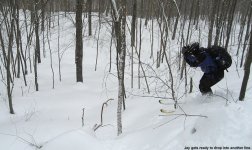
We followed what looked like a snowshoe track for a bit, but then that track headed straight up a slope with a pitch of probably 25 degrees or more. Without even trying the slope, I knew it was going to be way too steep for the skins, so we broke away from the convenience of the pre-made track, and made a switchback. At that point, the reality of the snowpack we'd found finally hit us. I had wanted to find unconsolidated snow from the new storm, and boy had we found it. I'm sure the snow from the nor'easter had settled a bit by that point, but it couldn't have been much. Even with my fat skis, I was sinking a foot or two down into the powder. Breaking trail in that stuff was noticeably slower than what I'd skinned through the previous weekend. It was slow, but it was fun, and we were in no hurry.
Eventually our switchback brought us back around to the snowshoe track, which headed up another relatively steep pitch. This pitch looked borderline skinnable, so we decided to give it a shot. At that point it was basically a toss up between saving a good bit of energy and time following the snowshoe track, or breaking trail for another switchback. I think we made the right choice, but just barely. Even with full-width skins, we were slipping some on that pitch. Dave, whose skis are a bit narrower than mine, actually had to make a mini switchback to get past the crux of that pitch. We even had our heel lifters at their maximum setting. I don't usually find myself skinning up slopes that require the highest setting of the heel lifter, so when I've got that one going, I know the pitch is steep. Often, a little help from your poles can mean that difference between slipping or not, but with such deep, unconsolidated snow, they were much less help than usual. We were also using poles with small alpine baskets, so that didn't help. But, we made it to the top of the pitch, and were happy to find some flatter ground.
In the flat area at the top of that pitch, we came across someone's snow cave. The snowshoe tracks we'd been following seemed to stop in this area, so it looked like someone had hiked up on snowshoes and had themselves a little outing in the new snow. The cave was nothing too elaborate, it just looked like they'd used the technique of piling up a mound of snow, letting it settle, and digging a hole in it. It looked like the cave had done its job though, because we looked inside and didn't find a frozen body.
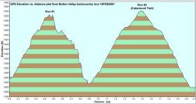
Beyond the snow cave, the terrain was flat for a bit, and we had to decide how much higher we wanted to go. We could see the next pitch a few dozen yards beyond, and it looked like there was a really steep, rocky face that was holding snow. I knew that making turns in this powder was going to require some steep pitches, so we headed a bit further through the flats to have a look at the pitch. I don't think the rocky area would have been too skiable without some drops, but to the south of it, there were numerous steep lines that were well-covered. We decided to do another switchback and get to the top of that pitch. A logging road made the going pretty easy, although the deep unconsolidated snow still kept our pace slow.
We hit that top of that pitch, and decided that was enough elevation gain for our first run. We found a place to stop for a snack and switch to ski mode, and as soon as I got out of my skis, I sunk up to my waist in the snow. It had started snowing during our trip up, and by the time we were hanging out and having a snack, it was really dumping huge, fat flakes. There's nothing like big, fat fluffy snowflakes falling from the sky to set the mood for a ski day. We'd received and inch or two of new snow already, which added a little extra fluffiness to the snowpack. We packed out an area in the snow in which to hang out, made ourselves some contoured snow seats, and we had a good rap session before starting our run.
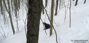
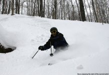
Bottomless is definitely the word to describe the skiing. It was fortunate there were some steep pitches to ski, because that's the only place you even had a chance to make turns. But, it was really fun to dive into stuff that would normally require some speed control, and just let the skis go. We shot some photos on the steeper pitches, and really just had to straight line/shuffle through the low-angle terrain. With a foot or so of powder, one could probably make continuous turns through all the terrain, but that just wasn't the case with 3 to 4 feet of unconsolidated snow. A couple of times on the descent, we encountered some ascending hikers on snowshoes, and one woman asked us where the trails went. We had to inform her that beyond the snow cave, the only thing was our skin track, and that only went up one more pitch. Not long after she climbed above us and hit the level of the snow cave, she seemed to turn around and head back down, so she might have headed elsewhere to find a packed trail.
We got back down to the car and still wanted to explore a little more. That Catamount Trail was right there to our north, so we decided to head up that and see what we found. We signed in at the trailhead, although the sign-in board seemed to be ignored by a lot of people. There were just a few ragged sheets of paper in there, and the setup looked in a state of disrepair. Skinning on the packed surface of the Catamount Trail was quite a change from breaking trail in the deep powder, and we moved along pretty quickly. There were probably 3 inches of new snow at that point, so swishing through that made for pleasant travel. We passed along the edge of the large clearing in the area that is evident on all the maps, although I'm still not sure exactly what it is. It was hard to tell with all the deep snow, but it looked like a cross between a gravel pit, and an area for some sort of outdoor activity. There were a lot of stakes and signs set up to mark out an area for something. We weren't planning to ski any terrain off the Catamount Trail itself, but I kept my eyes open for potential alpine skiing terrain that could be explored on future trips. On the uphill side off to our left, there was nothing in the immediate area that had too much pitch. Off to our right however, things looked a little more promising. The terrain dropped steeply down toward the Joiner Brook, and it looked like you might be able to get a couple hundred vertical feet of nice steep turns if you dropped off the Catamount Trail. The trees were certainly open enough for skiing. We could hear people down there, presumably on the Nordic trails, and it felt like one could pick up the Joiner Brook Nordic trail at the bottom. The Bolton Valley Nordic trail map shows that the Joiner Brook trail connects right back up with Catamount Trail, so that could be a nice mini loop. That will have to be explored at some point.
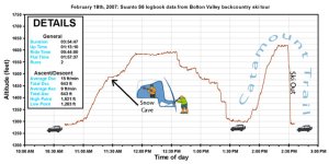
We decided to keep skinning up the Catamount Trail until it stopped rising, which turned out to be a few hundred vertical feet, very similar to our first run. At that point, we switched to ski mode and got ready to head down. We met a Nordic skier there who was going to check out Loki's Loop, but not long after he passed us and headed down toward the parking area, he returned because Loki's hadn't been touched since the new snow. I knew exactly what it was like breaking trail through that stuff in my fat powder skis, and I can only imagine what it might have been like on skinny Nordic gear. Dave and I started our run down the trail, and kept a moderate pace, just in case any Nordic skiers were ascending the trail. We were still able to make some great turns in the few inches of powder over the packed base. It was pleasant cruising in fresh powder, and for fun, I made some figure eights off Dave's tracks. The Avocet recorded 670' of descent for the day, and the Suunto recorded 643', a difference of 4.1%.
So, Dave and I had a fun outing in Bolton's backcountry, got some steep and deep powder turns, and even did some reconnaissance for future outings. The temperature had stayed around 20 F during the trip, so it was pleasant, even if the sun wasn't out. The few inches of new snow were a nice treat as well. Down at the house in Waterbury, we picked up 1.8 inches of new snow from that event, our 25th valley snowfall event for 2006-2007. That brought us to exactly 90.0 inches of accumulation for the season at the house, with a settled snowpack of 33 inches. The way the season had started, I never thought we'd have reached 90 inches of valley snowfall by the middle of February, but that's the way things have been going since January. We're now up to 91.2 inches of accumulation for the season, and unless the next storm forecast for tonight and tomorrow really fizzles, we should be knocking on and walking through the door to the 100-inch accumulation milestone soon. Winter storm warnings were issued this morning, with 10-16 inches predicted here in the valley. If that verifies, we'll certainly hit the 100-inch mark, and the mountains should do even better. Our snowpack in the yard has settled down to only 25 inches now after a high this season of 37 inches right after the nor'easter. We might be right back up at that level again though after this next storm.
Additional pictures can be found at:
http://www.jandeproductions.com/2007/18FEB07.html
J.Spin
While skiing at Bolton Valley on Saturday after the nor'easter, E and I discovered that the resort's mainly west-facing slopes had been blasted with strong winds from the storm. Instead of bottomless powder, we found mostly wind-packed surfaces that while challenging and somewhat fun to ski, were certainly not the cream of what this storm had to offer in terms of ski surfaces. The weather since the storm had remained cool, so there had to be some fluffy, wind-sheltered powder sitting out there somewhere; I just needed to choose terrain of the right aspect and elevation to find it. The previous weekend, I had explored the backcountry ski terrain above the V.A.S.T. parking area on the west side of the Bolton Valley Access Road. The snow and terrain there had given me about 1,000 vertical feet of fun powder skiing down from the western ridge of the valley, and the area was also on the leeward side of the prevailing winds. To mix things up a bit and get in some additional exploring, I thought it would be fun to start at the next popular access point up the road, the parking area near the Catamount Trail.
A bit of backcountry skiing also seemed like a good choice at that point because we were in the heart of a holiday ski weekend with excellent snow. That combination can often mean big crowds on the slopes. E and I had experienced part of the initial rush of holiday skiers when we left Bolton around noon on Saturday, and the crowds were likely to just get bigger on Sunday now that more people had arrived. Dave had come up to Vermont for a visit to check out the new snow, and was excited to join me for some backcountry turns. He said he didn't really mind what we skied; he just wanted to get out and enjoy the snow.
Dave and I hung out at the house for a while with E and the boys, and then in the late morning, we headed out to ski. There had been some sun for E and I when we'd skied on Saturday, but now it was cloudy and the forecast called for more snow. I was surprised to find that the parking lot at the Catamount trailhead was empty, even at the late hour we arrived. I had seen it packed the other day when I was leaving Bolton. Dave and I geared up, and we headed westward up into the trees. The trail sign indicated that we were on "Basta's Bastion", one of Bolton Valley's Nordic trails. So, just like the lower V.A.S.T. parking area that had access to the "Jake" trail, this spot was integrated with Bolton's Nordic trail network. That Bolton Nordic network is simply vast.
We followed what looked like a snowshoe track for a bit, but then that track headed straight up a slope with a pitch of probably 25 degrees or more. Without even trying the slope, I knew it was going to be way too steep for the skins, so we broke away from the convenience of the pre-made track, and made a switchback. At that point, the reality of the snowpack we'd found finally hit us. I had wanted to find unconsolidated snow from the new storm, and boy had we found it. I'm sure the snow from the nor'easter had settled a bit by that point, but it couldn't have been much. Even with my fat skis, I was sinking a foot or two down into the powder. Breaking trail in that stuff was noticeably slower than what I'd skinned through the previous weekend. It was slow, but it was fun, and we were in no hurry.
Eventually our switchback brought us back around to the snowshoe track, which headed up another relatively steep pitch. This pitch looked borderline skinnable, so we decided to give it a shot. At that point it was basically a toss up between saving a good bit of energy and time following the snowshoe track, or breaking trail for another switchback. I think we made the right choice, but just barely. Even with full-width skins, we were slipping some on that pitch. Dave, whose skis are a bit narrower than mine, actually had to make a mini switchback to get past the crux of that pitch. We even had our heel lifters at their maximum setting. I don't usually find myself skinning up slopes that require the highest setting of the heel lifter, so when I've got that one going, I know the pitch is steep. Often, a little help from your poles can mean that difference between slipping or not, but with such deep, unconsolidated snow, they were much less help than usual. We were also using poles with small alpine baskets, so that didn't help. But, we made it to the top of the pitch, and were happy to find some flatter ground.
In the flat area at the top of that pitch, we came across someone's snow cave. The snowshoe tracks we'd been following seemed to stop in this area, so it looked like someone had hiked up on snowshoes and had themselves a little outing in the new snow. The cave was nothing too elaborate, it just looked like they'd used the technique of piling up a mound of snow, letting it settle, and digging a hole in it. It looked like the cave had done its job though, because we looked inside and didn't find a frozen body.
Beyond the snow cave, the terrain was flat for a bit, and we had to decide how much higher we wanted to go. We could see the next pitch a few dozen yards beyond, and it looked like there was a really steep, rocky face that was holding snow. I knew that making turns in this powder was going to require some steep pitches, so we headed a bit further through the flats to have a look at the pitch. I don't think the rocky area would have been too skiable without some drops, but to the south of it, there were numerous steep lines that were well-covered. We decided to do another switchback and get to the top of that pitch. A logging road made the going pretty easy, although the deep unconsolidated snow still kept our pace slow.
We hit that top of that pitch, and decided that was enough elevation gain for our first run. We found a place to stop for a snack and switch to ski mode, and as soon as I got out of my skis, I sunk up to my waist in the snow. It had started snowing during our trip up, and by the time we were hanging out and having a snack, it was really dumping huge, fat flakes. There's nothing like big, fat fluffy snowflakes falling from the sky to set the mood for a ski day. We'd received and inch or two of new snow already, which added a little extra fluffiness to the snowpack. We packed out an area in the snow in which to hang out, made ourselves some contoured snow seats, and we had a good rap session before starting our run.
Bottomless is definitely the word to describe the skiing. It was fortunate there were some steep pitches to ski, because that's the only place you even had a chance to make turns. But, it was really fun to dive into stuff that would normally require some speed control, and just let the skis go. We shot some photos on the steeper pitches, and really just had to straight line/shuffle through the low-angle terrain. With a foot or so of powder, one could probably make continuous turns through all the terrain, but that just wasn't the case with 3 to 4 feet of unconsolidated snow. A couple of times on the descent, we encountered some ascending hikers on snowshoes, and one woman asked us where the trails went. We had to inform her that beyond the snow cave, the only thing was our skin track, and that only went up one more pitch. Not long after she climbed above us and hit the level of the snow cave, she seemed to turn around and head back down, so she might have headed elsewhere to find a packed trail.
We got back down to the car and still wanted to explore a little more. That Catamount Trail was right there to our north, so we decided to head up that and see what we found. We signed in at the trailhead, although the sign-in board seemed to be ignored by a lot of people. There were just a few ragged sheets of paper in there, and the setup looked in a state of disrepair. Skinning on the packed surface of the Catamount Trail was quite a change from breaking trail in the deep powder, and we moved along pretty quickly. There were probably 3 inches of new snow at that point, so swishing through that made for pleasant travel. We passed along the edge of the large clearing in the area that is evident on all the maps, although I'm still not sure exactly what it is. It was hard to tell with all the deep snow, but it looked like a cross between a gravel pit, and an area for some sort of outdoor activity. There were a lot of stakes and signs set up to mark out an area for something. We weren't planning to ski any terrain off the Catamount Trail itself, but I kept my eyes open for potential alpine skiing terrain that could be explored on future trips. On the uphill side off to our left, there was nothing in the immediate area that had too much pitch. Off to our right however, things looked a little more promising. The terrain dropped steeply down toward the Joiner Brook, and it looked like you might be able to get a couple hundred vertical feet of nice steep turns if you dropped off the Catamount Trail. The trees were certainly open enough for skiing. We could hear people down there, presumably on the Nordic trails, and it felt like one could pick up the Joiner Brook Nordic trail at the bottom. The Bolton Valley Nordic trail map shows that the Joiner Brook trail connects right back up with Catamount Trail, so that could be a nice mini loop. That will have to be explored at some point.
We decided to keep skinning up the Catamount Trail until it stopped rising, which turned out to be a few hundred vertical feet, very similar to our first run. At that point, we switched to ski mode and got ready to head down. We met a Nordic skier there who was going to check out Loki's Loop, but not long after he passed us and headed down toward the parking area, he returned because Loki's hadn't been touched since the new snow. I knew exactly what it was like breaking trail through that stuff in my fat powder skis, and I can only imagine what it might have been like on skinny Nordic gear. Dave and I started our run down the trail, and kept a moderate pace, just in case any Nordic skiers were ascending the trail. We were still able to make some great turns in the few inches of powder over the packed base. It was pleasant cruising in fresh powder, and for fun, I made some figure eights off Dave's tracks. The Avocet recorded 670' of descent for the day, and the Suunto recorded 643', a difference of 4.1%.
So, Dave and I had a fun outing in Bolton's backcountry, got some steep and deep powder turns, and even did some reconnaissance for future outings. The temperature had stayed around 20 F during the trip, so it was pleasant, even if the sun wasn't out. The few inches of new snow were a nice treat as well. Down at the house in Waterbury, we picked up 1.8 inches of new snow from that event, our 25th valley snowfall event for 2006-2007. That brought us to exactly 90.0 inches of accumulation for the season at the house, with a settled snowpack of 33 inches. The way the season had started, I never thought we'd have reached 90 inches of valley snowfall by the middle of February, but that's the way things have been going since January. We're now up to 91.2 inches of accumulation for the season, and unless the next storm forecast for tonight and tomorrow really fizzles, we should be knocking on and walking through the door to the 100-inch accumulation milestone soon. Winter storm warnings were issued this morning, with 10-16 inches predicted here in the valley. If that verifies, we'll certainly hit the 100-inch mark, and the mountains should do even better. Our snowpack in the yard has settled down to only 25 inches now after a high this season of 37 inches right after the nor'easter. We might be right back up at that level again though after this next storm.
Additional pictures can be found at:
http://www.jandeproductions.com/2007/18FEB07.html
J.Spin


")