J.Spin
Member
A link to larger versions of the images is available at the bottom of the report, and you can click on the running images to link to full size versions.
For many years I've been eyeing an interesting piece of potential ski terrain during my travels along Interstate 89 east of Burlington. While passing through the spine of the Green Mountains, I often found myself looking southward at a steep, twisting gully that dropped down to the Winooski Valley. The gully, which contains the next stream east of Gleason Brook, is carved out of the ridge of terrain that gradually descends from Camel's Hump. The prominent point at the end of the ridge is at and elevation of roughly 1,500 feet, and is capped with evergreens that make it stand out a bit from the hardwoods below. There's no name given to the end of the ridge, but it does mark the point where the Long Trail cuts sharply to the south after rising from the Wiley Lodge area along Gleason Brook. Of course, I know all these details now, but it took a bit of investigation to get to this point.
Whenever I see one of these roadside attractions that I want to ski, there's always the chance that it's just a pipe dream. There are a lot of hurdles to cross. Some of these are just difficult logistics to conquer, but some are things that will put the nail in the coffin on the whole scheme. First off, there's the issue of actually finding an access point to the terrain you've seen from afar. Seeing something a mile or two off in the distance is one thing, but actually getting to it can be a whole different matter when there's no address to guide you and there's no road that leads there. There's definitely a bit of "can't see the trees for the forest" sort of thing that goes on, in that you can't see the details of a big place when you're way off in the distance. You can see the large geographic feature and the forest, but trying to find the specific "tree" that represents an efficient entry point into the trailless terrain is the hard part. Thankfully, modern day conveniences like TopoZone, MapQuest, Google Earth, and GPS units help out a lot with this issue. Next, you don't always know if the terrain is on someone's private land, or if you'd have to cross someone's private land to get to it. Is there a place to park your car that will give you relatively easy access to where you want to go? Or, are you going to have to park ½ mile away from your entry point because the closest road is narrow, has no shoulders, and every single piece of space off the road is in someone's yard. Oh, and don't forget that when you actually want to go and ski this piece of real estate, there's probably going to be a heaping helping of recent snowfall, so you've got huge snowbanks along the road that further complicate the problem. A spot in which you can easily park the car in the off season, may be filled with a six-foot pile of snow in the winter. Then, if you pass these hurdles and actually get to the terrain, you may find that it's not even skiable due to excessive rocks or too much underbrush etc. And, if all these hurdles weren't challenging enough, you still need to rely on Mother Nature to build a sufficient snowpack to make the whole thing skiable. But, I do love these sorts of challenges.")
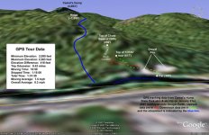
After eyeing the gully of interest (which I dubbed "The Snake" because of the way it twisted down the mountain) for many weeks as I drove between Waterbury and Burlington, I finally had a chance to seek it out this past October and check on its potential for skiing. I knew that the best chance at access would be somewhere off Duxbury/River Road on the south side of the Winooski River, but I also knew from experience that I wasn't easily going to find it by driving around on the road. Once you're up close to the terrain, you're in the trees right below it and you just can't see it. So, combined with the difficulty of locating the details for entering the area ("can't see the trees for the forest") there can also be the problem of not knowing if you're in the right area because you can't see the major feature you're looking for when you're right on top of it ("can't see the forest for the trees"). It's a bit of a catch 22. Fortunately, I was able to use my GPS unit to mark a point on Route 2/I-89 from where I could see the gully, and then drive on the Duxbury/River Road until I was directly across the river from that point. From there, I at least that knew the gully was right above me... somewhere. Thank heavens for the GPS technology that makes a project like this so much easier than it might be. There was still a margin of error of course, but once I had a relative fix, I knew all that was needed was some exploring in the general area. I also found what appeared be a convenient place to park vehicles, as there was a dirt road right there that supplied access to a couple of gravel pits. The coup de grace for the first reconnaissance day (October 3rd, 2006) was when I spotted a little yellow tag nailed to a tree by the road to the gravel pits. The diamond-shaped tag had green writing on it that contained an image of the Vermont state coat of arms, surrounded by the words "VERMONT STATE LANDS". Seeing that tag, I knew I'd just passed another potentially big hurdle. I knew there was at least some public land near the base of this gully - that was really good news. On the first day, I had the time to take just a brief look around. I got a few snapshots, marked the spot with my GPS, and noted the location of the gravel pits. Then I headed home and hopped on the computer to try to confirm where I'd been with the help of MapSource, TopoZone, MapQuest, and Google Earth. Google Earth had only low-resolution images of the area, but MapQuest had higher-resolution images that clearly showed the locations of the two gravel pits in its "aerial image" mode. I was also happy to see that MapQuest had nice public land boundaries in its "street map" mode. It looked like the area I had explored was inside Camel's Hump State Park, and it was conveniently one of the spots where the state land came right down to Duxbury/River Road. I was satisfied that I had actually been where I'd hoped to be, and I got ready for reconnaissance day two.


On October 7th, I headed back to the area for my first real reconnaissance hike. It was a beautiful, warm October day. The foliage was well on its way, and the leaves had already fallen from many of the trees. The car was parked at an elevation of 380 feet off Duxbury/River Road near the eastern (left) gravel pit. It was probably about 10 feet above the elevation of the Winooski River in that area. I couldn't spy an obvious entrance into the woods, so I decided to head right up the face of the eastern gravel pit to get things started. The pitch of the gravel pit's face was probably 45 degrees in places, and it was really tough to climb. I thought of how it would actually be a fun pitch to ski if it ever got enough snow to sufficiently cover the gravel. By the time I'd reached the top, I knew there had to be an easier way to get up there. It had taken a lot of slipping and grabbing to get up the steep slope of loose gravel. However, there was a grand view from the top of the gravel pit, as I'd quickly jumped up to an elevation of 485 feet and there were no trees in front of me to obstruct the vistas to the north across the valley. I snapped some pictures of the area with the fall colors, and then headed south toward the woods.

The terrain immediately above the gravel pit was flat, and it was clear of trees. It looked like this area had been cleared in association with the use of the gravel pit. Beyond the cleared area was a section of small saplings that went on for several yards, and then came the bigger trees. I kept myself moving in a southeasterly direction, heading towards the direction of the streambed I sought. At first, the trees were a little thick, but after just a couple minutes of hiking, I came across my first exciting discovery. I looked up and saw a beautiful slope covered with big, widely spaced hardwoods and hardly any undergrowth. The slope went up more than 100 vertical feet, and was consistently pitched at around 30 degrees. The forest floor was devoid of rocks (except for one big dishwasher-sized one that looked like it would make a nice jump). It was absolutely prime tree-skiing terrain. I continued up the beautiful open slope, eager to see if this arrangement of flora was just an oddity, or if there was more to come. Well, there was more to come. After flattening out briefly at the top of the first pitch, the terrain rose again, with obvious open lines for skiing. I'd already seen enough to forget about my trip over to the streambed at this point. The second pitch was a bit mellower than the first, and not as long, but I remember thinking how cool it was to have these great pieces of tree-skiing terrain back to back.
Above the second pitch, I started to run into the first signs of small ledges that would be too steep to ski. So, instead of trying to continue southeast, I yielded to the terrain and contoured eastward on the flats along the base of the ledges. I suddenly came into an area where rocks littered the ground below a covering of ferns, and it actually became a bit tough to walk on the rocks because I couldn't always see my feet. These rocks were in the range of basketball-sized or slightly larger, and I wondered what made them collect on the ground there. I soon found out. I continued eastward through the rock garden, and came to the base of beautiful tree-lined chute. It was possible that these rocks had fallen from above, and the rock fall may have been what was keeping much of the plant growth from taking root in the chute. I hiked up the chute for about 200 vertical feet until I had to stop. I had run into the base of some huge cliffs that rose 100 feet above me, and there was no moving upward beyond that point. I had reached an elevation of 850 feet, and that would have to be the top of this potential ski run. The cliffs above me were quite impressive. They actually hung out beyond vertical in areas. It wasn't hard to imagine massive chunks of rock falling off the sheer faces of the cliffs and wreaking havoc on the vegetation as they tumbled their way in to the forest below. The cliffs barred my path upward, but I was satisfied because I'd already seen enough. I was looking down a beautiful tree-lined chute that probably topped out at an angle of 35 degrees. In the roughly 500 vertical feet I'd traveled up from the road, I'd already seen plenty of potential ski terrain to make me return to the spot in the winter with my skis.

Everything had worked out as well as I could have hoped up to that point. It was public land, there was likely to be a place to park even when the snowbanks were deep, and the terrain was all ready to be skied. It just needed snow. The prospects for sufficient snow were what worried me the most. This was very low-elevation terrain. The hike I'd just completed covered the elevation range from about 350 feet above sea level at the car, to about 850 feet above sea level at the top of the chute. That's just about as low as it gets in these parts. It looked like the lower glade areas could be skied with as little as a foot of snow due to their lack of underbrush and rocks, but the chute would probably need a couple of feet of snow depth. It was steeper than the glades below, and it was also a bit rockier. In a typical year, skiing would only be practical in the area in the middle of the season, and in lean years it probably wouldn't be skiable at all. Everything would depend on the valley snowpack. Still, I'd skied plenty of low-elevation stuff like this in the past (Robbins Mountain, Brownell Mountain, Mt. Philo, etc.) with a typical valley snowpack, so I knew it was possible. At least the sun wasn't going to be a problem. The terrain was shaded by trees and the cliffs above, and it all faced north.
The possibility of skiing easily-accessed terrain down to the valley again had me pretty psyched, as I'd missed these types of exploratory sessions when I was out in Montana. These types of excursions weren't possible in the Bitterroot Valley where we'd lived for the past five ski seasons. Skiing-wise, that was probably the biggest shock that I had to accept when we moved out to Montana: our valley (and most others in the region) just didn't build a snowpack. We lived in Hamilton at an elevation of roughly 3,600 feet above sea level, but you had to go a couple thousand feet above that to find a snowpack that would last for any duration during the winter. I constantly had to snap myself back to reality whenever I'd gaze at attractive roadside ski terrain, because it was never going to have snow. It's probably not even that strange a phenomenon for someone who grows up in Montana, but for someone growing up in Northern Vermont where we usually have a consistent valley snowpack, it was definitely different. Montana had plenty of great skiing of course; you just couldn't typically walk out your back door and get to it if you lived in the valley.
The afternoon of my second reconnaissance was getting on, but I descended the chute and headed east to at least take a token look in the direction where I suspected the streambed to be. I found the forest to be littered with car to truck-sized boulders that had presumably fallen from the cliffs above. I hopped up on one of these giant boulders to get a bird's eye view of the forest, and didn't spy any terrain that looked as good as the stuff I'd already found. It's interesting that on my first day of real exploration, I never even made it to the streambed that had inspired the whole adventure to begin with. But, I'd found some great ski terrain nonetheless. I figured the streambed, as steep as it looked from the road, would probably need more snow than the terrain I'd looked at already. There was always the chance that the streambed was relatively clear and would make a great run depending on how the stream froze, but I figured I'd catch a look at the streambed on my next trip to the area. I headed back to the car following roughly the same route I'd taken to get into the woods, although I bypassed the gravel pit by taking a small gully that came off its western side. Climbing up the gravel pit, I'd already been on the verge of slipping, so I didn't want to deal with trying to get down that way. I also wanted to find a route around the gravel pit because I knew there would be no heading up the steep gravel inclines on skins. My route brought me back down to the road that ran between the two gravel pits, and I made a mental note of the exit location so I'd remember it for next time.
That next time actually came the following day, October 8th. My friend Chris was visiting, and E and the boys were away, so Chris and I took a trip back to the area. I showed Chris the terrain I'd explored the previous day, and then we finished off the hike with a trip to the streambed as I'd planned. We didn't have time to travel high up the streambed, but we explored the bottom ¼ of it as we followed it out to the Duxbury/River Road. The grade of the stream was rather mellow in the area we examined, although there was the potential for some skiing if the whole thing froze over and became covered with snow. We actually found another "VERMONT STATE LANDS" marker on one of the huge boulders in the streambed, and we assumed we'd found the eastern edge of the chunk of Camel's Hump State Park that we'd been roaming around in. Numerous small tributaries of water merged together in the drainage, and the stream became essentially flat as we approached Duxbury/River Road. Once at the road, we followed it back westward to the car. It was a fun hike, and while we'd found that the lower area of the streambed offered at least the chance for some low-angle turns, it didn't offer nearly the potential of the terrain I'd initially found to the west. Perhaps next season I can actually investigate the higher reaches of the streambed that kicked this whole adventure off to begin with. It's just a great place to go for a hike, especially with the fall weather and foliage.


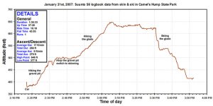
Let's flash forward a few months to Sunday, January 21st, 2007. It's mid winter, and ski season in Vermont. The way the early winter had been going in Northern Vermont, I wondered if we'd ever get to a valley snowpack that made it worth even looking at the ski terrain with snow on it, but in January the snowpack in the Waterbury area finally began to build. It started off with the MLK-weekend storm, which dropped 6.9 inches of snow at our house and left us with a 5-inch snowpack that had a substantial crust. This was potential base material, so in a way the crust was good thing. Then, on January 19th and 20th, an upslope event dropped an additional 12.8 inches of snow on us, bringing our snowpack in the back yard to somewhere between 16 and 17 inches. Our house is at 495 feet above sea level, and just a few miles from the ski terrain we'd scouted, so the snowpack at our place was likely a good measure of conditions in the local area. I decided that we'd at least reached a critical mass of snow worth having a look at the ski terrain, and so that plan was set for a backcountry trip with my friend Chris. I had initially thought we'd head up to Bolton Valley to earn some turns on the Timberline or Wilderness areas that day, but both lifts had opened for the weekend due to the recent snowfall. That was great for the lift-served skiing of course, but it pretty much put the kibosh on using the ski runs for earned turns.
Sunday morning I'd actually gone skiing with Ty up at Bolton Valley to take advantage of the newly-opened Wilderness Lift, and while the temperature had only been in the single digits, the sun was out, the wind was down, and the temperature was rising. Chris came over to the house around noontime, we had some lunch with the family and friends that were over, and then we headed off for an afternoon look at what the recent snow had done for our potential ski terrain. As Chris and I headed toward the Jonesville Bridge to get us across the Winooski River, we were surprised to see that high clouds were moving in from the west and appeared to be stealing our light. It had been so sunny out, and it wasn't supposed to cloud up. We arrived at the road to the gravel pits, and unfortunately it looked as though they weren't going to be plowed that access road during the winter. On the plus side, there was only about a foot of thick snow forming the snowbank, and at least one vehicle had passed through it to head down the road in the direction of the western gravel pit. Trying to park along the edge of Duxbury/River Road wasn't practical as it wasn't plowed much beyond the two main lanes, and there was a blind corner to the west. We checked out the snow on the gravel pit road, and Chris was confident his vehicle could handle it. The snowbank itself was thick, chunky, settled snow, but beyond that it was just fluff. We backed in with the aid of the tracks that had been made by the other vehicle, moved off to the side to keep the gravel pit road free, and we had our spot. We may need to find a more creative parking solution (or actually have to pull out the shovels) if we come back when the snowbanks area really big.
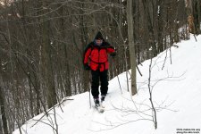
We already had our skins on our skis, but we started out hiking in ski boots instead of skinning. The entry route we'd been using on the west side of the eastern gravel pit was way too steep and narrow for skins. It was actually a bit of a tough climb in the snow, and we knew we'd want to find a better approach in the future. At the top of the eastern gravel pit, we skinned up, and took a few photos of the view. Fortunately, the high clouds were passing and the blue sky had reappeared. We were going to be in north-facing terrain under trees. At this time of year and at this latitude, the light was still going to be low even with the sunshine. From the top of the gravel pit, the snow didn't look too bad towards the woods, although down in the gravel pit itself, the eastern side had areas of dirt visible. It had obviously been blasted by the wind. It would have been fun to finish off a run with some turns down the steep slope of the pit, but that certainly wasn't going to happen on the eastern side. We still held out hope for the western side, but we'd have to check out the snow on the way down.

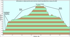
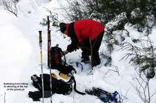
We skinned into the woods, and with the foliage off the deciduous trees, we could see a lot more than we could back in October. We could soon see the gladed pitch of interest, and the snow cover looked decent. We couldn't tell what the base would be like, but we knew it was mostly leaves so we wouldn't have to worry about our skis (or our safety) due to underlying rocks and other debris. I set a skin track angling up the eastern side of the pitch, trying my best to keep that happy medium between a relatively shallow grade and one that actually gains vertical. We encountered a couple of tough spots where we would hit a downed branch that wasn't fully covered by the snow, and that took a little muscling with the poles. As those who've done it know, trying to cross a large branch (or log in one case) that is in line with the slope can be a bit of a slippery challenge. It felt like I would never find a decent spot to switch our skin track back to the west, but I did, and after a couple more switchbacks we'd gained the top of the first slope at an elevation of around 620 feet.
Based on the time, and the fact that this was really just an initial exploratory mission to check out how the skiing would be with the current snow depths, we stopped our upward progress at the top of the first pitch. Even before checking, I could tell that this snow might be enough for the glades, but it definitely wasn't enough for the chute up above. I checked the snowpack depth with a gauge I'd added to one of my ski poles, and after poking around in several spots, I discovered the snowpack was a consistent 11 inches deep. This was substantially less than the 16-17 inches I'd measured in my back yard on Saturday, but I hadn't checked the depth in my yard on Sunday, so I couldn't tell if this area just had less snow, or if it was a result of the fluff settling. We were only a few miles from the house, and at a similar elevation, but it's possible the few miles could have made a difference in snowfall. Also, the trees could have slowed some of the snow accumulation on the ground. What was also interesting was that the crust (which we were counting on to make our base) varied in its distribution. In some places we could find it, and in others we found just fluff to the ground. This may also have been due to the sheltering of the trees. A few days after the trip, I got around to doing a check on the snowpack at our house. I found that the snow in our yard had settled down to a similar depth, so my guess it that settling was the basis for the decreased depth we found.

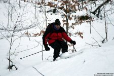
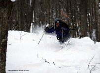
Even knowing that there were only 11 inches of settled snow on average, we were confident the slope below us was skiable based on our previous explorations. We had a drink, geared up, and then we skied some powder. We took turns skiing down the slope and getting photos, and it really wasn't half bad. Personally, I skied cautiously in spots, because even though we knew the slope was relatively clear, there could always be that little something sitting under the snow. Chris took the same approach, since it wouldn't have been fun to break a piece of equipment or injure ourselves, especially on this little exploratory mission. On a few turns, we actually went down to the leaves on the ground (the slope is in the range of 30 degrees so you do have to have some bite to your turns) but in most spots the snow was sufficient to keep us up. Still, I would say this was just about the minimum you would want for this slope. There's a nice big rock jump on the slope as well, but that's going to take significantly more snow to be a practical addition to a run. Overall, there were some great powder turns made, we had some fun, we learned about the snow depth needed for the area, and we managed to get a few photos. I was really happy to see how well the cameras performed, even under such low light and with only f/4 lenses.
We slid out through the flat area below the slope, and returned back to the top of the gravel pit. I did a brief inspection of the western flank of the pit, vainly hoping to find that a base had somehow settle there, but there was no such luck. The pit was mostly fluff on gravel, and it would have meant a nasty stone grind for our ski bases (and probably a tumble down the slope for our bodies) if we tried to ski it with the snowpack that was there at the time. So, we'll have to see what sort of depth is required for that at some point in the future. With skiing the gravel pit absolutely not an option, we took off our skis and slid our way down the small gully to the west to get to the gravel pit road. Getting back down the gully with ski gear was its own little adventure, and was enough to convince me that we absolutely need to find a better approach route to the terrain. We were happy to discover that Chris' vehicle had no problem getting out of the snow and right back onto the road, so that saved us some potential digging. It's never fun to finish a tour (even a small one like ours) and then have to spend your energy digging out a vehicle.
So all in all, I'm pretty impressed with what could be skied in the area on what is really our first lasting snowpack of the season. If it was skiable in this season (which many people say was one of the worst starts they can remember) there's no question that it will provide some nice turns in an average year. In terms of base material, all one needs to be able to ski the lower gladed terrain is probably a nice six inches of settled snowpack. Then, throw a foot of powder on top of that, and it's game on. I was hoping that the five inches of snow with a crust that we'd had in our yard was going to make the solid base there, but it wasn't quite a "real" base. Fluff covered by a bit of crust doesn't quite match up to six inches of heavy, settled snow. With such low elevation for the terrain, it's never going to be the kind of backcountry you can ski consistently from November to April every season, but the access is pretty easy if you want to head out for a couple hours and you live in the Waterbury/Burlington area. Most upslope snowfall events aren't going to fill in these low-elevation areas like they do the mountains, but maybe one of these days we'll actually get another nor'easter. Technically I haven't experienced a nor'easter for quite a while since we've been out in Montana, but I hear tell them things can bring a "wicked" amount of snow to these parts.
We've had four small snow events this past week, but nothing too big. The biggest story has been the temperatures. On Thursday morning at we broke this season's record for the coldest morning at our house with a temperature of -12.1 F. But, we just smashed that this morning with a new low of -16.4 F. In terms of snowfall this week, we picked up 0.2 inches from the Monday event, 2.2 inches from the Wednesday event, 0.5 inches from the Thursday/Friday event, and so far 0.5 inches from today's event. That gives us a total of 3.4 inches this week, and puts us at 49.7 inches of snowfall on the season. We'll have to see how long it takes to get to the 50-inch mark. I estimate the annual snowfall here is at around 100 inches, so hitting the 50-inch mark is a bit of a milestone. We've probably got at least half of the snowfall season left, so we'll have to see what Mother Nature brings us. This week's valley accumulations aren't enough to significantly bump up the snowpack down here, but Bolton is reporting 14 inches of snow in the past 7 days. I think some of that might include the tail end of last weekend's upslope event, but I've been watching the daily snow reports and they've probably had somewhere in the range of 6 to 12 inches of total accumulation out of these small artic snow events. It might be time for some backcountry exploration up there, since tomorrow's forecast suggests a high near 20 degrees F and at least a chance for sun down here in the valley.
Larger version of the pictures, map, and data are available through the following link:
http://www.jandeproductions.com/2007/21JAN07PM.html
J.Spin
For many years I've been eyeing an interesting piece of potential ski terrain during my travels along Interstate 89 east of Burlington. While passing through the spine of the Green Mountains, I often found myself looking southward at a steep, twisting gully that dropped down to the Winooski Valley. The gully, which contains the next stream east of Gleason Brook, is carved out of the ridge of terrain that gradually descends from Camel's Hump. The prominent point at the end of the ridge is at and elevation of roughly 1,500 feet, and is capped with evergreens that make it stand out a bit from the hardwoods below. There's no name given to the end of the ridge, but it does mark the point where the Long Trail cuts sharply to the south after rising from the Wiley Lodge area along Gleason Brook. Of course, I know all these details now, but it took a bit of investigation to get to this point.
Whenever I see one of these roadside attractions that I want to ski, there's always the chance that it's just a pipe dream. There are a lot of hurdles to cross. Some of these are just difficult logistics to conquer, but some are things that will put the nail in the coffin on the whole scheme. First off, there's the issue of actually finding an access point to the terrain you've seen from afar. Seeing something a mile or two off in the distance is one thing, but actually getting to it can be a whole different matter when there's no address to guide you and there's no road that leads there. There's definitely a bit of "can't see the trees for the forest" sort of thing that goes on, in that you can't see the details of a big place when you're way off in the distance. You can see the large geographic feature and the forest, but trying to find the specific "tree" that represents an efficient entry point into the trailless terrain is the hard part. Thankfully, modern day conveniences like TopoZone, MapQuest, Google Earth, and GPS units help out a lot with this issue. Next, you don't always know if the terrain is on someone's private land, or if you'd have to cross someone's private land to get to it. Is there a place to park your car that will give you relatively easy access to where you want to go? Or, are you going to have to park ½ mile away from your entry point because the closest road is narrow, has no shoulders, and every single piece of space off the road is in someone's yard. Oh, and don't forget that when you actually want to go and ski this piece of real estate, there's probably going to be a heaping helping of recent snowfall, so you've got huge snowbanks along the road that further complicate the problem. A spot in which you can easily park the car in the off season, may be filled with a six-foot pile of snow in the winter. Then, if you pass these hurdles and actually get to the terrain, you may find that it's not even skiable due to excessive rocks or too much underbrush etc. And, if all these hurdles weren't challenging enough, you still need to rely on Mother Nature to build a sufficient snowpack to make the whole thing skiable. But, I do love these sorts of challenges.
After eyeing the gully of interest (which I dubbed "The Snake" because of the way it twisted down the mountain) for many weeks as I drove between Waterbury and Burlington, I finally had a chance to seek it out this past October and check on its potential for skiing. I knew that the best chance at access would be somewhere off Duxbury/River Road on the south side of the Winooski River, but I also knew from experience that I wasn't easily going to find it by driving around on the road. Once you're up close to the terrain, you're in the trees right below it and you just can't see it. So, combined with the difficulty of locating the details for entering the area ("can't see the trees for the forest") there can also be the problem of not knowing if you're in the right area because you can't see the major feature you're looking for when you're right on top of it ("can't see the forest for the trees"). It's a bit of a catch 22. Fortunately, I was able to use my GPS unit to mark a point on Route 2/I-89 from where I could see the gully, and then drive on the Duxbury/River Road until I was directly across the river from that point. From there, I at least that knew the gully was right above me... somewhere. Thank heavens for the GPS technology that makes a project like this so much easier than it might be. There was still a margin of error of course, but once I had a relative fix, I knew all that was needed was some exploring in the general area. I also found what appeared be a convenient place to park vehicles, as there was a dirt road right there that supplied access to a couple of gravel pits. The coup de grace for the first reconnaissance day (October 3rd, 2006) was when I spotted a little yellow tag nailed to a tree by the road to the gravel pits. The diamond-shaped tag had green writing on it that contained an image of the Vermont state coat of arms, surrounded by the words "VERMONT STATE LANDS". Seeing that tag, I knew I'd just passed another potentially big hurdle. I knew there was at least some public land near the base of this gully - that was really good news. On the first day, I had the time to take just a brief look around. I got a few snapshots, marked the spot with my GPS, and noted the location of the gravel pits. Then I headed home and hopped on the computer to try to confirm where I'd been with the help of MapSource, TopoZone, MapQuest, and Google Earth. Google Earth had only low-resolution images of the area, but MapQuest had higher-resolution images that clearly showed the locations of the two gravel pits in its "aerial image" mode. I was also happy to see that MapQuest had nice public land boundaries in its "street map" mode. It looked like the area I had explored was inside Camel's Hump State Park, and it was conveniently one of the spots where the state land came right down to Duxbury/River Road. I was satisfied that I had actually been where I'd hoped to be, and I got ready for reconnaissance day two.
On October 7th, I headed back to the area for my first real reconnaissance hike. It was a beautiful, warm October day. The foliage was well on its way, and the leaves had already fallen from many of the trees. The car was parked at an elevation of 380 feet off Duxbury/River Road near the eastern (left) gravel pit. It was probably about 10 feet above the elevation of the Winooski River in that area. I couldn't spy an obvious entrance into the woods, so I decided to head right up the face of the eastern gravel pit to get things started. The pitch of the gravel pit's face was probably 45 degrees in places, and it was really tough to climb. I thought of how it would actually be a fun pitch to ski if it ever got enough snow to sufficiently cover the gravel. By the time I'd reached the top, I knew there had to be an easier way to get up there. It had taken a lot of slipping and grabbing to get up the steep slope of loose gravel. However, there was a grand view from the top of the gravel pit, as I'd quickly jumped up to an elevation of 485 feet and there were no trees in front of me to obstruct the vistas to the north across the valley. I snapped some pictures of the area with the fall colors, and then headed south toward the woods.
The terrain immediately above the gravel pit was flat, and it was clear of trees. It looked like this area had been cleared in association with the use of the gravel pit. Beyond the cleared area was a section of small saplings that went on for several yards, and then came the bigger trees. I kept myself moving in a southeasterly direction, heading towards the direction of the streambed I sought. At first, the trees were a little thick, but after just a couple minutes of hiking, I came across my first exciting discovery. I looked up and saw a beautiful slope covered with big, widely spaced hardwoods and hardly any undergrowth. The slope went up more than 100 vertical feet, and was consistently pitched at around 30 degrees. The forest floor was devoid of rocks (except for one big dishwasher-sized one that looked like it would make a nice jump). It was absolutely prime tree-skiing terrain. I continued up the beautiful open slope, eager to see if this arrangement of flora was just an oddity, or if there was more to come. Well, there was more to come. After flattening out briefly at the top of the first pitch, the terrain rose again, with obvious open lines for skiing. I'd already seen enough to forget about my trip over to the streambed at this point. The second pitch was a bit mellower than the first, and not as long, but I remember thinking how cool it was to have these great pieces of tree-skiing terrain back to back.
Above the second pitch, I started to run into the first signs of small ledges that would be too steep to ski. So, instead of trying to continue southeast, I yielded to the terrain and contoured eastward on the flats along the base of the ledges. I suddenly came into an area where rocks littered the ground below a covering of ferns, and it actually became a bit tough to walk on the rocks because I couldn't always see my feet. These rocks were in the range of basketball-sized or slightly larger, and I wondered what made them collect on the ground there. I soon found out. I continued eastward through the rock garden, and came to the base of beautiful tree-lined chute. It was possible that these rocks had fallen from above, and the rock fall may have been what was keeping much of the plant growth from taking root in the chute. I hiked up the chute for about 200 vertical feet until I had to stop. I had run into the base of some huge cliffs that rose 100 feet above me, and there was no moving upward beyond that point. I had reached an elevation of 850 feet, and that would have to be the top of this potential ski run. The cliffs above me were quite impressive. They actually hung out beyond vertical in areas. It wasn't hard to imagine massive chunks of rock falling off the sheer faces of the cliffs and wreaking havoc on the vegetation as they tumbled their way in to the forest below. The cliffs barred my path upward, but I was satisfied because I'd already seen enough. I was looking down a beautiful tree-lined chute that probably topped out at an angle of 35 degrees. In the roughly 500 vertical feet I'd traveled up from the road, I'd already seen plenty of potential ski terrain to make me return to the spot in the winter with my skis.
Everything had worked out as well as I could have hoped up to that point. It was public land, there was likely to be a place to park even when the snowbanks were deep, and the terrain was all ready to be skied. It just needed snow. The prospects for sufficient snow were what worried me the most. This was very low-elevation terrain. The hike I'd just completed covered the elevation range from about 350 feet above sea level at the car, to about 850 feet above sea level at the top of the chute. That's just about as low as it gets in these parts. It looked like the lower glade areas could be skied with as little as a foot of snow due to their lack of underbrush and rocks, but the chute would probably need a couple of feet of snow depth. It was steeper than the glades below, and it was also a bit rockier. In a typical year, skiing would only be practical in the area in the middle of the season, and in lean years it probably wouldn't be skiable at all. Everything would depend on the valley snowpack. Still, I'd skied plenty of low-elevation stuff like this in the past (Robbins Mountain, Brownell Mountain, Mt. Philo, etc.) with a typical valley snowpack, so I knew it was possible. At least the sun wasn't going to be a problem. The terrain was shaded by trees and the cliffs above, and it all faced north.
The possibility of skiing easily-accessed terrain down to the valley again had me pretty psyched, as I'd missed these types of exploratory sessions when I was out in Montana. These types of excursions weren't possible in the Bitterroot Valley where we'd lived for the past five ski seasons. Skiing-wise, that was probably the biggest shock that I had to accept when we moved out to Montana: our valley (and most others in the region) just didn't build a snowpack. We lived in Hamilton at an elevation of roughly 3,600 feet above sea level, but you had to go a couple thousand feet above that to find a snowpack that would last for any duration during the winter. I constantly had to snap myself back to reality whenever I'd gaze at attractive roadside ski terrain, because it was never going to have snow. It's probably not even that strange a phenomenon for someone who grows up in Montana, but for someone growing up in Northern Vermont where we usually have a consistent valley snowpack, it was definitely different. Montana had plenty of great skiing of course; you just couldn't typically walk out your back door and get to it if you lived in the valley.
The afternoon of my second reconnaissance was getting on, but I descended the chute and headed east to at least take a token look in the direction where I suspected the streambed to be. I found the forest to be littered with car to truck-sized boulders that had presumably fallen from the cliffs above. I hopped up on one of these giant boulders to get a bird's eye view of the forest, and didn't spy any terrain that looked as good as the stuff I'd already found. It's interesting that on my first day of real exploration, I never even made it to the streambed that had inspired the whole adventure to begin with. But, I'd found some great ski terrain nonetheless. I figured the streambed, as steep as it looked from the road, would probably need more snow than the terrain I'd looked at already. There was always the chance that the streambed was relatively clear and would make a great run depending on how the stream froze, but I figured I'd catch a look at the streambed on my next trip to the area. I headed back to the car following roughly the same route I'd taken to get into the woods, although I bypassed the gravel pit by taking a small gully that came off its western side. Climbing up the gravel pit, I'd already been on the verge of slipping, so I didn't want to deal with trying to get down that way. I also wanted to find a route around the gravel pit because I knew there would be no heading up the steep gravel inclines on skins. My route brought me back down to the road that ran between the two gravel pits, and I made a mental note of the exit location so I'd remember it for next time.
That next time actually came the following day, October 8th. My friend Chris was visiting, and E and the boys were away, so Chris and I took a trip back to the area. I showed Chris the terrain I'd explored the previous day, and then we finished off the hike with a trip to the streambed as I'd planned. We didn't have time to travel high up the streambed, but we explored the bottom ¼ of it as we followed it out to the Duxbury/River Road. The grade of the stream was rather mellow in the area we examined, although there was the potential for some skiing if the whole thing froze over and became covered with snow. We actually found another "VERMONT STATE LANDS" marker on one of the huge boulders in the streambed, and we assumed we'd found the eastern edge of the chunk of Camel's Hump State Park that we'd been roaming around in. Numerous small tributaries of water merged together in the drainage, and the stream became essentially flat as we approached Duxbury/River Road. Once at the road, we followed it back westward to the car. It was a fun hike, and while we'd found that the lower area of the streambed offered at least the chance for some low-angle turns, it didn't offer nearly the potential of the terrain I'd initially found to the west. Perhaps next season I can actually investigate the higher reaches of the streambed that kicked this whole adventure off to begin with. It's just a great place to go for a hike, especially with the fall weather and foliage.
Let's flash forward a few months to Sunday, January 21st, 2007. It's mid winter, and ski season in Vermont. The way the early winter had been going in Northern Vermont, I wondered if we'd ever get to a valley snowpack that made it worth even looking at the ski terrain with snow on it, but in January the snowpack in the Waterbury area finally began to build. It started off with the MLK-weekend storm, which dropped 6.9 inches of snow at our house and left us with a 5-inch snowpack that had a substantial crust. This was potential base material, so in a way the crust was good thing. Then, on January 19th and 20th, an upslope event dropped an additional 12.8 inches of snow on us, bringing our snowpack in the back yard to somewhere between 16 and 17 inches. Our house is at 495 feet above sea level, and just a few miles from the ski terrain we'd scouted, so the snowpack at our place was likely a good measure of conditions in the local area. I decided that we'd at least reached a critical mass of snow worth having a look at the ski terrain, and so that plan was set for a backcountry trip with my friend Chris. I had initially thought we'd head up to Bolton Valley to earn some turns on the Timberline or Wilderness areas that day, but both lifts had opened for the weekend due to the recent snowfall. That was great for the lift-served skiing of course, but it pretty much put the kibosh on using the ski runs for earned turns.
Sunday morning I'd actually gone skiing with Ty up at Bolton Valley to take advantage of the newly-opened Wilderness Lift, and while the temperature had only been in the single digits, the sun was out, the wind was down, and the temperature was rising. Chris came over to the house around noontime, we had some lunch with the family and friends that were over, and then we headed off for an afternoon look at what the recent snow had done for our potential ski terrain. As Chris and I headed toward the Jonesville Bridge to get us across the Winooski River, we were surprised to see that high clouds were moving in from the west and appeared to be stealing our light. It had been so sunny out, and it wasn't supposed to cloud up. We arrived at the road to the gravel pits, and unfortunately it looked as though they weren't going to be plowed that access road during the winter. On the plus side, there was only about a foot of thick snow forming the snowbank, and at least one vehicle had passed through it to head down the road in the direction of the western gravel pit. Trying to park along the edge of Duxbury/River Road wasn't practical as it wasn't plowed much beyond the two main lanes, and there was a blind corner to the west. We checked out the snow on the gravel pit road, and Chris was confident his vehicle could handle it. The snowbank itself was thick, chunky, settled snow, but beyond that it was just fluff. We backed in with the aid of the tracks that had been made by the other vehicle, moved off to the side to keep the gravel pit road free, and we had our spot. We may need to find a more creative parking solution (or actually have to pull out the shovels) if we come back when the snowbanks area really big.
We already had our skins on our skis, but we started out hiking in ski boots instead of skinning. The entry route we'd been using on the west side of the eastern gravel pit was way too steep and narrow for skins. It was actually a bit of a tough climb in the snow, and we knew we'd want to find a better approach in the future. At the top of the eastern gravel pit, we skinned up, and took a few photos of the view. Fortunately, the high clouds were passing and the blue sky had reappeared. We were going to be in north-facing terrain under trees. At this time of year and at this latitude, the light was still going to be low even with the sunshine. From the top of the gravel pit, the snow didn't look too bad towards the woods, although down in the gravel pit itself, the eastern side had areas of dirt visible. It had obviously been blasted by the wind. It would have been fun to finish off a run with some turns down the steep slope of the pit, but that certainly wasn't going to happen on the eastern side. We still held out hope for the western side, but we'd have to check out the snow on the way down.
We skinned into the woods, and with the foliage off the deciduous trees, we could see a lot more than we could back in October. We could soon see the gladed pitch of interest, and the snow cover looked decent. We couldn't tell what the base would be like, but we knew it was mostly leaves so we wouldn't have to worry about our skis (or our safety) due to underlying rocks and other debris. I set a skin track angling up the eastern side of the pitch, trying my best to keep that happy medium between a relatively shallow grade and one that actually gains vertical. We encountered a couple of tough spots where we would hit a downed branch that wasn't fully covered by the snow, and that took a little muscling with the poles. As those who've done it know, trying to cross a large branch (or log in one case) that is in line with the slope can be a bit of a slippery challenge. It felt like I would never find a decent spot to switch our skin track back to the west, but I did, and after a couple more switchbacks we'd gained the top of the first slope at an elevation of around 620 feet.
Based on the time, and the fact that this was really just an initial exploratory mission to check out how the skiing would be with the current snow depths, we stopped our upward progress at the top of the first pitch. Even before checking, I could tell that this snow might be enough for the glades, but it definitely wasn't enough for the chute up above. I checked the snowpack depth with a gauge I'd added to one of my ski poles, and after poking around in several spots, I discovered the snowpack was a consistent 11 inches deep. This was substantially less than the 16-17 inches I'd measured in my back yard on Saturday, but I hadn't checked the depth in my yard on Sunday, so I couldn't tell if this area just had less snow, or if it was a result of the fluff settling. We were only a few miles from the house, and at a similar elevation, but it's possible the few miles could have made a difference in snowfall. Also, the trees could have slowed some of the snow accumulation on the ground. What was also interesting was that the crust (which we were counting on to make our base) varied in its distribution. In some places we could find it, and in others we found just fluff to the ground. This may also have been due to the sheltering of the trees. A few days after the trip, I got around to doing a check on the snowpack at our house. I found that the snow in our yard had settled down to a similar depth, so my guess it that settling was the basis for the decreased depth we found.
Even knowing that there were only 11 inches of settled snow on average, we were confident the slope below us was skiable based on our previous explorations. We had a drink, geared up, and then we skied some powder. We took turns skiing down the slope and getting photos, and it really wasn't half bad. Personally, I skied cautiously in spots, because even though we knew the slope was relatively clear, there could always be that little something sitting under the snow. Chris took the same approach, since it wouldn't have been fun to break a piece of equipment or injure ourselves, especially on this little exploratory mission. On a few turns, we actually went down to the leaves on the ground (the slope is in the range of 30 degrees so you do have to have some bite to your turns) but in most spots the snow was sufficient to keep us up. Still, I would say this was just about the minimum you would want for this slope. There's a nice big rock jump on the slope as well, but that's going to take significantly more snow to be a practical addition to a run. Overall, there were some great powder turns made, we had some fun, we learned about the snow depth needed for the area, and we managed to get a few photos. I was really happy to see how well the cameras performed, even under such low light and with only f/4 lenses.
We slid out through the flat area below the slope, and returned back to the top of the gravel pit. I did a brief inspection of the western flank of the pit, vainly hoping to find that a base had somehow settle there, but there was no such luck. The pit was mostly fluff on gravel, and it would have meant a nasty stone grind for our ski bases (and probably a tumble down the slope for our bodies) if we tried to ski it with the snowpack that was there at the time. So, we'll have to see what sort of depth is required for that at some point in the future. With skiing the gravel pit absolutely not an option, we took off our skis and slid our way down the small gully to the west to get to the gravel pit road. Getting back down the gully with ski gear was its own little adventure, and was enough to convince me that we absolutely need to find a better approach route to the terrain. We were happy to discover that Chris' vehicle had no problem getting out of the snow and right back onto the road, so that saved us some potential digging. It's never fun to finish a tour (even a small one like ours) and then have to spend your energy digging out a vehicle.
So all in all, I'm pretty impressed with what could be skied in the area on what is really our first lasting snowpack of the season. If it was skiable in this season (which many people say was one of the worst starts they can remember) there's no question that it will provide some nice turns in an average year. In terms of base material, all one needs to be able to ski the lower gladed terrain is probably a nice six inches of settled snowpack. Then, throw a foot of powder on top of that, and it's game on. I was hoping that the five inches of snow with a crust that we'd had in our yard was going to make the solid base there, but it wasn't quite a "real" base. Fluff covered by a bit of crust doesn't quite match up to six inches of heavy, settled snow. With such low elevation for the terrain, it's never going to be the kind of backcountry you can ski consistently from November to April every season, but the access is pretty easy if you want to head out for a couple hours and you live in the Waterbury/Burlington area. Most upslope snowfall events aren't going to fill in these low-elevation areas like they do the mountains, but maybe one of these days we'll actually get another nor'easter. Technically I haven't experienced a nor'easter for quite a while since we've been out in Montana, but I hear tell them things can bring a "wicked" amount of snow to these parts.
We've had four small snow events this past week, but nothing too big. The biggest story has been the temperatures. On Thursday morning at we broke this season's record for the coldest morning at our house with a temperature of -12.1 F. But, we just smashed that this morning with a new low of -16.4 F. In terms of snowfall this week, we picked up 0.2 inches from the Monday event, 2.2 inches from the Wednesday event, 0.5 inches from the Thursday/Friday event, and so far 0.5 inches from today's event. That gives us a total of 3.4 inches this week, and puts us at 49.7 inches of snowfall on the season. We'll have to see how long it takes to get to the 50-inch mark. I estimate the annual snowfall here is at around 100 inches, so hitting the 50-inch mark is a bit of a milestone. We've probably got at least half of the snowfall season left, so we'll have to see what Mother Nature brings us. This week's valley accumulations aren't enough to significantly bump up the snowpack down here, but Bolton is reporting 14 inches of snow in the past 7 days. I think some of that might include the tail end of last weekend's upslope event, but I've been watching the daily snow reports and they've probably had somewhere in the range of 6 to 12 inches of total accumulation out of these small artic snow events. It might be time for some backcountry exploration up there, since tomorrow's forecast suggests a high near 20 degrees F and at least a chance for sun down here in the valley.
Larger version of the pictures, map, and data are available through the following link:
http://www.jandeproductions.com/2007/21JAN07PM.html
J.Spin