Driving from Mammoth May 9 I got a call from Jane Wyckoff, Far West Ski Association Convention Chairperson. FWSA awarded me the Bill Berry Hard News Award for 2025
So she asked if I could attend the annual convention in Palm Springs to receive it. I said yes, and when I got home and examined the schedule, I noticed the Public Affairs Panel: Climate Change and the Future of Snowsports.
I sent Jane a few charts on the topic which I had previously prepared for the NASJA Northeast Weather Summit in 2018, so she invited me onto the panel.
Far West Ski Association is an association of ski clubs of the Pacific States, plus Arizona , Nevada and Idaho. Officers at the start of the Saturday lunch meeting:

Climate Change and Snowsports Panel:

Jane Wyskoff presenting me with the award:

We had considered when in Palm Springs in May for the DesertX art installations that we might return to hike San Jacinto from the Palm Springs tram. So that’s what we did Sunday. The tram opens 8AM weekends and 10AM weekdays. We were on the 8:45AM tram.


Even by Alps standards this is a steep tram, climbing from 2,643 feet to 8,516 feet.
We saw several people with these packs.

San Jacinto is a very rocky mountain, and there are some places very convenient to the upper tram station for rock climbing.

View of San Jacinto Peak from the upper tram station:

The hike is 6 miles one way mostly through forest. This was fortunate because high was 85F at the upper tram and reputedly 117F in Palm Springs. We started hiking 10AM
Map:

Wellman’s Divide at 3.2 miles and 9,700 feet is the first spot on the trail with any kind of view.

This is looking south around noon; highest peaks in that direction are about 8,800.
My age/altitude situation got worse above Wellman’s so Liz eventually went on ahead of me. As the trail heads south, it eventually breaks out of the forest into a bushy hillside.

This is around the last time that the upper tram station is visible.

Liz found this heart shaped rock by the trail interesting.

These bushes get buried in a decent winter.

Ben Solish and Adam skied this on AT gear in February 2017.
Most of the trail was about as rocky as this.

I slowed my pace, but with step ups over rocks still had to take short breaks every 20 minutes or so. I had no overt altitude symptoms like headache but just moved very slowly. The only comparable experience was at 14,000 feet on Mt. Whitney in 1999.
Liz looked inside this hut just short of the peak but I was too tired.

The final ~300 vertical is a scramble over boulders.


My guess by distance and elevation gain was that we would summit at 3PM. Liz got there at 2:50.

The boulders necessitated two rest stops for me, and on the second one I got dizzy. I called Liz to warn her that I was close but not sure how much longer it would take. She was on the summit but within earshot. When I got there at 3:15 I rested quite a while.

View west over Lake Perris toward L.A.:

That’s probably Baldy in upper right corner.
View southwest over Diamond Valley reservoir with crows soaring above the peak:

View northeast of the wind farms in San Gorgonio Pass:

I had to crawl carefully onto the proper boulder to get the view down the precipitous north face.

That’s a 9,000 foot vertical drop to the I-10 and route 111 junction, rare in the US lower 48 states. San Jacinto has a higher spire measure than any place in Utah or Colorado and ranks 6th in California.
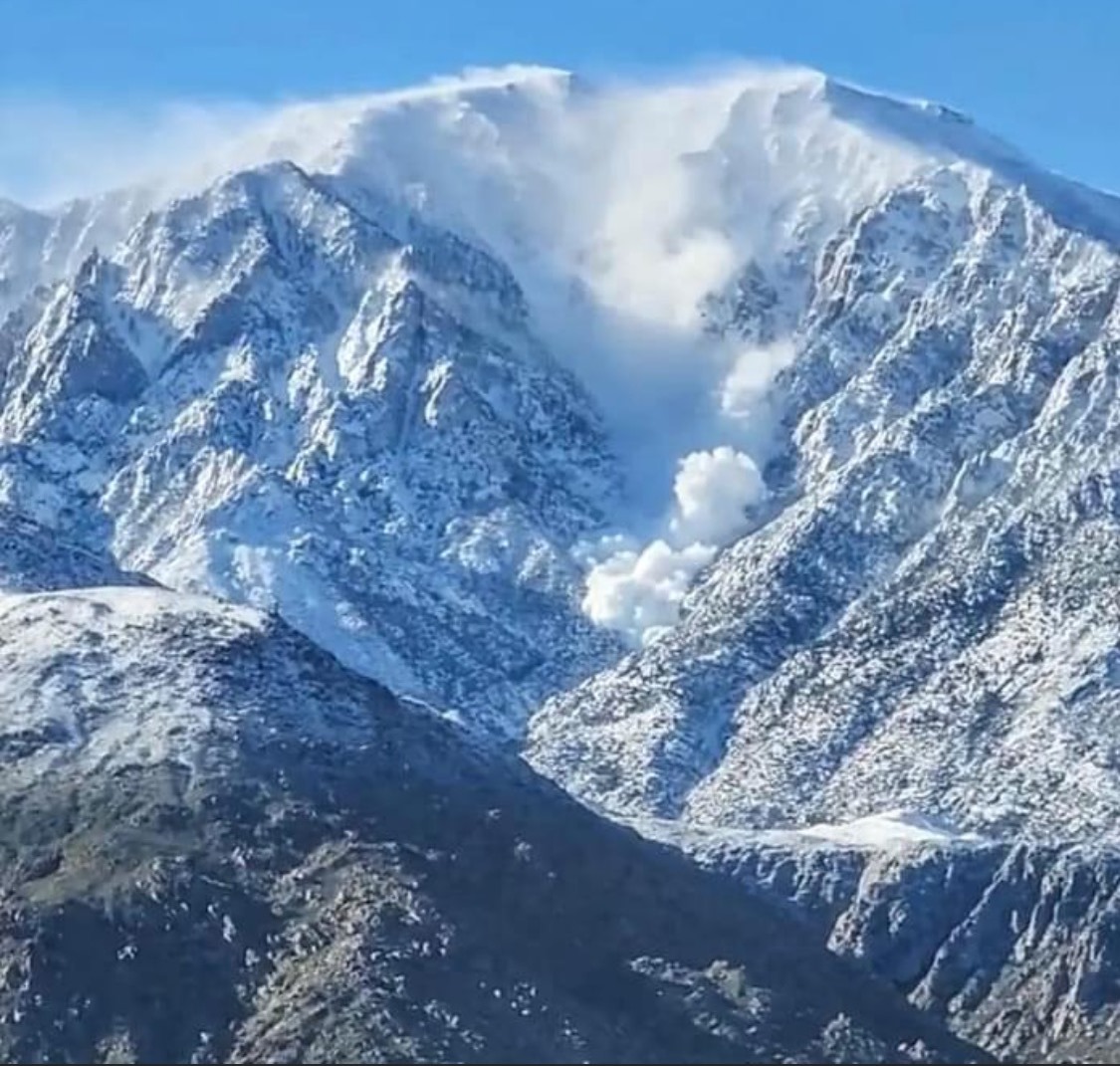
You can ski maybe half of that in spring of a high snow year. But recall what happened here after the big dump of February 2023.
View east over Coachella Valley from Palm Springs to Indio:

Zoom southeast to the Salton Sea:

Back on top together before we headed down at 4PM:

Even in the forest we pass lots of boulders.

We got back to the tram station about 7:50 and rode the tram down about 8:15PM.

So she asked if I could attend the annual convention in Palm Springs to receive it. I said yes, and when I got home and examined the schedule, I noticed the Public Affairs Panel: Climate Change and the Future of Snowsports.
I sent Jane a few charts on the topic which I had previously prepared for the NASJA Northeast Weather Summit in 2018, so she invited me onto the panel.
Far West Ski Association is an association of ski clubs of the Pacific States, plus Arizona , Nevada and Idaho. Officers at the start of the Saturday lunch meeting:
Climate Change and Snowsports Panel:
Jane Wyskoff presenting me with the award:
We had considered when in Palm Springs in May for the DesertX art installations that we might return to hike San Jacinto from the Palm Springs tram. So that’s what we did Sunday. The tram opens 8AM weekends and 10AM weekdays. We were on the 8:45AM tram.
Even by Alps standards this is a steep tram, climbing from 2,643 feet to 8,516 feet.
We saw several people with these packs.
San Jacinto is a very rocky mountain, and there are some places very convenient to the upper tram station for rock climbing.
View of San Jacinto Peak from the upper tram station:
The hike is 6 miles one way mostly through forest. This was fortunate because high was 85F at the upper tram and reputedly 117F in Palm Springs. We started hiking 10AM
Map:
Wellman’s Divide at 3.2 miles and 9,700 feet is the first spot on the trail with any kind of view.
This is looking south around noon; highest peaks in that direction are about 8,800.
My age/altitude situation got worse above Wellman’s so Liz eventually went on ahead of me. As the trail heads south, it eventually breaks out of the forest into a bushy hillside.
This is around the last time that the upper tram station is visible.
Liz found this heart shaped rock by the trail interesting.
These bushes get buried in a decent winter.
Ben Solish and Adam skied this on AT gear in February 2017.
Most of the trail was about as rocky as this.
I slowed my pace, but with step ups over rocks still had to take short breaks every 20 minutes or so. I had no overt altitude symptoms like headache but just moved very slowly. The only comparable experience was at 14,000 feet on Mt. Whitney in 1999.
Liz looked inside this hut just short of the peak but I was too tired.
The final ~300 vertical is a scramble over boulders.
My guess by distance and elevation gain was that we would summit at 3PM. Liz got there at 2:50.
The boulders necessitated two rest stops for me, and on the second one I got dizzy. I called Liz to warn her that I was close but not sure how much longer it would take. She was on the summit but within earshot. When I got there at 3:15 I rested quite a while.
View west over Lake Perris toward L.A.:
That’s probably Baldy in upper right corner.
View southwest over Diamond Valley reservoir with crows soaring above the peak:
View northeast of the wind farms in San Gorgonio Pass:
I had to crawl carefully onto the proper boulder to get the view down the precipitous north face.
That’s a 9,000 foot vertical drop to the I-10 and route 111 junction, rare in the US lower 48 states. San Jacinto has a higher spire measure than any place in Utah or Colorado and ranks 6th in California.
You can ski maybe half of that in spring of a high snow year. But recall what happened here after the big dump of February 2023.
View east over Coachella Valley from Palm Springs to Indio:
Zoom southeast to the Salton Sea:
Back on top together before we headed down at 4PM:
Even in the forest we pass lots of boulders.
We got back to the tram station about 7:50 and rode the tram down about 8:15PM.
Last edited:
") But a fit, young person would think that hike was a breeze.
But a fit, young person would think that hike was a breeze.