Mayflower Mountain at Deer Valley

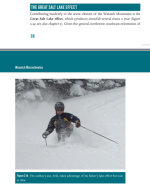
The lake effect—a meteorological phenomenon wherein cold air passes over a warmer lake—causes profoundly heavy snowfall along the Wasatch Range, precisely where the majority of ski resorts are situated.

Potentially for not all that much longer though: Great Salt Lake Drying Up/Overuse

Similar to when the great lakes freeze over in winter, once the fetch gets too small the lake effect will be over pretty quickly.
 
seems to imply that it's far more than what Steenburgh believes
Sorry, I trust Steenburgh way more than PeakRankings or the NY Times on the subject of Utah snow. As MarzNC notes above, he wrote the book on it, which I have and recommend highly.

Here's an interview with him with the lead question on the subject of the shrinking Great Salt Lake.
What is the true impact of The Great Salt Lake when you’re talking about mountain weather in your zone of the Wasatch?
Steenburgh: In the Cottonwoods, it’s about an average of about 5% of the cool season precipitation, so from October through April. We’ve done studies that vary from year to year: it can be as much as 10 or 12%. And it can be as little as almost zero. It depends on the patterns in any given year.
Steenburgh also visited Tug Hill in 2013 to study lake effect.

FYI when I was in SLC skiing over Memorial weekend 1985 the local concern was about flooding. The Great Salt Lake reached 4,212 feet in 1987 after 3 huge winters (Alta Collins 679, 619 and 694 inches) from 1982-1984 and resulting soil saturation. The Great Salt Lake is currently at 4,188 feet. But the current articles are correct. The issue is not drier weather but steeply increasing water consumption by development and agriculture.
 
Last edited:
Sorry, I trust Steenburgh way more than PeakRankings or the NY Times on the subject of Utah snow. As MarzNC notes above, he wrote the book on it, which I have and recommend highly.

Yes, I liked the analysis of the overall state of Utah, but I would disagree with their assertion that the Wasatch is overwhelmingly influenced by the Lake Effect of the relatively small Great Salt Lake.

I was not aware of Steenberg's book, but I read about 1/4 of it free online.


I really like the chart below for explaining Wasatch Snowfall. It is LCC's topography, not the lake effect—specifically, the uplift and the ability to receive snow from any storm direction.

(For example, Telluride is blocked chiefly from South-Southwest flow storms due to being on the backside of the San Juans in that type of storm. However, a relatively minor 2-6" storm coming into the canyon from the West-Northwest can easily dump 12-18".)

1761226147703.png
1761226191861.png


1761226916116.png


In short, Mayflower is located in a low snowfall, low elevation, and poor aspect area (maybe 100" per year, warm and faces early sun). Likely one of the worst Western resorts to ever be developed, and only possible due to technological development in snowmaking and maintenance.)

However, a few storms might be good.


1761227146508.png
 
One thing for sure is that if the predictions for the Salt Lake pan out it will be very easy to track how much is lake effect. If the average Alta snowfall drops by 25" (5%) vs 75" (15%) should be very easy to spot in the data.

I do recall Alta, Ski Utah, etc... touting lake enhanced snowfall for decades in thier marketing though. And so much talk of that lake effect getting caught in the upper canyons extending storms for hours after the actual storm had gone trough and etc... Based on the above, seems like that was a bunch of guessing and not really knowing why they got such good snowfall. Or maybe the Marketing types just loved a good story.
 
It's been addressed before but I forgot -- why does LCC get more than BCC and why does Alta get a bit more than Snowbird?
 
It's been addressed before but I forgot -- why does LCC get more than BCC and why does Alta get a bit more than Snowbird?
Why more snow for Alta? It is at the end of LCC and has a base elevation of 8.5k vs 8k for Snowbird. Also, has Tony C said that Alta measures their official snowfall count higher on the mountain than Snowbird?

Brighton and Solitude have similar elevations and snowfall as Alta-Bird, but perhaps their exposure is slightly different, resulting in slightly less snow.
 
One thing for sure is that if the predictions for the Salt Lake pan out it will be very easy to track how much is lake effect. If the average Alta snowfall drops by 25" (5%) vs 75" (15%) should be very easy to spot in the data.

I do recall Alta, Ski Utah, etc... touting lake enhanced snowfall for decades in thier marketing though. And so much talk of that lake effect getting caught in the upper canyons extending storms for hours after the actual storm had gone trough and etc... Based on the above, seems like that was a bunch of guessing and not really knowing why they got such good snowfall. Or maybe the Marketing types just loved a good story.

It appears Steenburgh thinks SL Effect Snow is a minor factor that only affects LCC Snowfall, since LCC is relatively short and closer to the lake. He implies that if it were more pronounced, the Oquirr Mountains would have high Wasatch-like snowfall.

I also hear ideas of the Lake Champlain Effect on maybe Sugarbush/MRG.

1761248016211.png

1761247637139.png


1761248180625.png
 

Attachments

  • 1761247589569.png
    1761247589569.png
    229.9 KB · Views: 25
Last edited:
It's been addressed before but I forgot -- why does LCC get more than BCC and why does Alta get a bit more than Snowbird?
Why more snow for Alta? It is at the end of LCC and has a base elevation of 8.5k vs 8k for Snowbird. Also, has Tony C said that Alta measures their official snowfall count higher on the mountain than Snowbird?

Brighton and Solitude have similar elevations and snowfall as Alta-Bird, but perhaps their exposure is slightly different, resulting in slightly less snow.

I knew altitude played a prominent role, but there is more.

Little Cottonwood Canyon acts like a snow trap:
  • More directly aligned with storm flow
  • Closer to the lake-effect plume
  • Steeper orographic lift
  • Convergent effect
That combination makes it one of the snowiest places in North America, often out-snowing Big Cottonwood by 80–120 inches per season.


1761248809168.png

1761248920050.png
 
ChatGPT was entirely accurate: Niseko is a 360-degree volcano and has plenty of NE (hike-out) and NW (backcountry; tour or taxi out after an ancient onsen). Combined with a larger vertical, a better mix of open terrain and trees, and a little challenging to access the best terrain, I would definitely return to Niseko again (and try some new areas to me around the Nagano and Furano areas).

Niseko overview and its backcountry gates: North is up.
1761250388433.png


Also, essential Niseko reading
 
Back
Top