Much more so than Coronet Peak and Cardrona.The Remarkables and Mt. Hutt
You are using an out of date browser. It may not display this or other websites correctly.
You should upgrade or use an alternative browser.
You should upgrade or use an alternative browser.
Oz/NZ 2025
- Thread starter Sbooker
- Start date
ChrisC
Well-known member
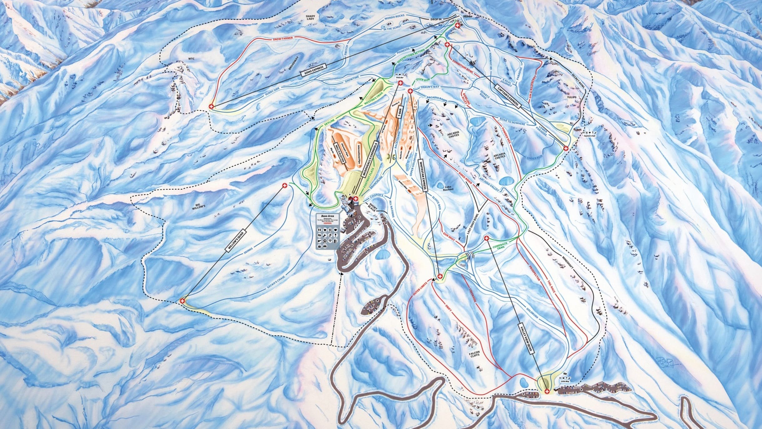
Cardrona is becoming a fairly large resort by Australian/New Zealand standards - or even Southern Hemisphere standards.
New Map/New Lift/New Terrain
 unofficialnetworks.com

New Map/New Lift/New Terrain
New Zealand's Largest Ski Resort Reveals New Trail Map
Cardrona revealed their newest trail map, which was designed by Rad Smith.
unofficialnetworks.com
Cardrona ski terrain has at least doubled with the two new terrain pods on the left side of that map. Before this it was the smallest of the 4 Southern Lakes areas. My day there in late July 1997 was under fairly low tide conditions. I was not motivated to revisit in 2006. I think my heliski day was the day our NASJA group went there.
Not skiing but anyway.
I’m trying to help Kylie be fit enough to climb Mount Barney as a day hike sometime soon. It’s quite a challenge with an elevation gain of 1234 metres over sometimes very difficult terrain. Yesterday we climbed Mount Greville that has a gain of about half that. The climb is through a gorge. The scenery on the way up and at the top is quite nice.


^^^ That is Mount Greville.

And sunset over Lake Moogerah.
I’m trying to help Kylie be fit enough to climb Mount Barney as a day hike sometime soon. It’s quite a challenge with an elevation gain of 1234 metres over sometimes very difficult terrain. Yesterday we climbed Mount Greville that has a gain of about half that. The climb is through a gorge. The scenery on the way up and at the top is quite nice.
^^^ That is Mount Greville.
And sunset over Lake Moogerah.
That's nothing to sniff at!It’s quite a challenge with an elevation gain of 1234 metres over sometimes very difficult terrain. Yesterday we climbed Mount Greville that has a gain of about half that.
jasoncapecod
Well-known member
I say this with peace and love, but I think it's more like a 1800 ft elevation change....That's nothing to sniff at!
3700 ft vert change is a real beast.
Which is why I’m helping her train for Mount Barney. She’ll have 4000 ft (1234 metres) vertical rise to tackle when we do that in a few weeks. And back down the same day…..3700 ft vert change is a real beast.
jasoncapecod
Well-known member
My longest single day hikeWhich is why I’m helping her train for Mount Barney. She’ll have 4000 ft (1234 metres) vertical rise to tackle when we do that in a few weeks. And back down the same day…..
Was paradise base camp to camp Muir
Round trip 9 miles almost 5k vert up 5k down
Mt Rainer
Very impressive given the peak elevation is 10000 feet. At a top elevation of 1300 metres Mount Barney doesn’t rob you of oxygen like Mt Rainier would.My longest single day hike
Was paradise base camp to camp Muir
Round trip 9 miles almost 5k vert up 5k down
Mt Rainer
My most challenging hikes:
June 2011 Mt. Shasta 9,200 - 13,200, to 11,000 with skins and ski crampons, after that skis on my back with boot crampons and an ice axe.
Sept. 1981 Half Dome 4,000 - 8,800 The down was worse than the up because I inflamed knee bursitis, very painful.
4x, May 1980-1983 Poopout Hill to San Gorgonio 7,700 - 11,200 mostly in snow with skis on my back.
Apr. 1990 Tuckerman Ravine, probably only day I've climbed more than 5K as I took 3 runs. Having half the downhill be on skis helped a lot.
Sept. 1999 Whitney Portal to Trail Camp 8,400 - 12,000 with full camping pack.
Nov. 2011 French Valley in Torres del Paine, Chile 230 - 3,600 but 15 miles total uneven rough trail with lots of up and down.
Nov. 2011 Laguna Los Tres at base of Fitzroy, Argentina 700 - 3,900 with steep loose rock switchbacks on the top section, 13 miles RT.
Dec. 2017 Lago Obsession, Chile was my steepest hike, 850 - 4,000 in 3.5 miles, resulting in some blisters for both Liz and me.
May 1970 South Kaibab Trail in the Grand Canyon 2,420 - 7,200. As a newbie hiker I was running around all day not conserving energy and really hit the wall with exhaustion on the way back up.
Sept. 2007 second day of the Inca Trail, Peru 9,800 - 13,800, then down to camp at 12,000. Easier than all of the above because:
1) 3 days acclimatizing in Cusco at 11,000
2) Smooth path from Inca engineering and modern maintenance.
3) Very light day packs because you have a staff of porters carrying and setting up everything needed for camping.
Those days are over. Yesterday Liz and I hiked San Jacinto from the Palm Springs tram, 8,415 - 10,834. The only hike I've been even close to that much out of breath was the summit day on Mt. Whitney 14,495.
Last edited:
Nice work Tony. Some bucket list locations in there. Some of those offered the huge reward of skiing virgin snow on the way down though. That makes the climb so much easier.My most challenging hikes:
June 2011 Mt. Shasta 9,200 - 13,200, to 11,000 with skins and ski crampons, after that skis on my back with boot crampons and an ice axe.
Sept. 1981 Half Dome 4,000 - 8,800 The down was worse than the up because I inflamed knee bursitis, very painful.
4x, May 1980-1983 Poopout Hill to San Gorgonio 7,700 - 11,200 mostly in snow with skis on my back.
Apr. 1990 Tuckerman Ravine, probably only day I've climbed more than 5K as I took 3 runs. Having half the downhill be on skis helped a lot.
Sept. 1999 Whitney Portal to Trail Camp 8,400 - 12,000 with full camping pack.
Nov. 2011 French Valley in Torres del Paine, Chile 230 - 3,600 but 15 miles total uneven rough trail with lots of up and down.
Nov. 2011 Laguna Los Tres at base of Fitzroy, Argentina 700 - 3,900 with steep loose rock switchbacks on the top section, 13 miles RT.
Dec. 2017 Lago Obsession, Chile was my steepest hike, 850 - 4,000 in 3.5 miles, resulting in some blisters for both Liz and me.
May 1970 South Kaibab Trail in the Grand Canyon 2,420 - 7,200. As a newbie hiker I was running around all day not conserving energy and really hit the wall with exhaustion on the way back up.
Sept. 2007 second day of the Inca Trail, Peru 9,800 - 13,800, then down to camp at 12,000. Easier than all of the above because:
1) 3 days acclimatizing in Cusco at 11,000
2) Smooth path from Inca engineering and modern maintenance.
3) Very light day packs because you have a staff of porters carrying and setting up everything needed for camping.
Those days are over. Yesterday Liz and I hiked San Jacinto from the Palm Springs tram, 8,400 - 10,834. The only hike I've been even close to that much out of breath was the summit day on Mt. Whitney 14,495.
EMSC
Well-known member
Some nice hikes in there.My most challenging hikes
Looking forward to seeing/hearing the trip/effort.I’m trying to help Kylie be fit enough to climb Mount Barney as a day hike sometime soon. It’s quite a challenge with an elevation gain of 1234 metres over sometimes very difficult terrain.
I used to hike quite a bit from boy scouting all the way until Jr came along; and I also got moderate patella femoral syndrome about the same time which started to hurt a lot, but only when down-hiking big vertical. Vast majority of my hiking was pre-FTO and mostly pre-Digital cameras (or at least no cell phone cameras and too big and heavy for digital cameras more often than not back in the day). I'd have to think a bit on my biggest or most challenging as there were bunch - including some ADK peaks with very steep trails (Giant Mtn for example).
Here's a fun old one. Kelso Ridge route for Torreys Peak just off I70 a few miles before the Eisenhower tunnels. Two NY'ers nearly killed themselves on this route just last week and had to be heli-evacuated at night (no idea how the heli pulled that off in the dark). It's not the vert, it's the exposure that'll get you on that particular route. Couple of true knife ridges with hundreds of vert drop on either side. Ironically standard route is most just a slightly oversized hike at high altitude. Kelso Ridge Route
ChrisC
Well-known member
Which is why I’m helping her train for Mount Barney. She’ll have 4000 ft (1234 metres) vertical rise to tackle when we do that in a few weeks. And back down the same day…..
My longest single day hike
Was paradise base camp to camp Muir
Round trip 9 miles almost 5k vert up 5k down
Mt Rainer
When I lived in Seattle, I became interested in climbing the glaciated volcanoes of the Cascade Range. Most mountaineering outfits for Mt. Rainier group clients together of differing abilities take them on the crowded and easiest route to Paradise for an overnight, and push them to via Disappointment Cleaver to the summit the next day (75% of summit traffic). Very little training or learning, more about $$$.
I found a Glacier Climbing Course offered through Bellevue Community College for Spring/Summer that lasted nearly 20 weeks (10 weeks of class once per week for 2-3 hours in the evening), and the rest was on-mountain training. Working in the suburbs (Issaquah, where Microsoft built its second campus after Redmond), Bellevue was the next stop on my westward commute home to Seattle proper, making it easy to incorporate/attend in my schedule. (My previous schedule was attending friends' IPO parties - debating the band and food spread...deciding whether you will retire at 35 or 40 )
I still have my syllabus somewhere, but everything was covered by an old-school NW guide, which ranged from nutrition and decision-making to gear, training, navigation, weather, glacier travel, crevasse rescue, and more.
Note: Down-climbing on glaciers can be very quick and not strenuous, as you can glissade (a method of sliding down a steep snow or ice slope, typically on your feet with the support of an ice axe). You will also need waterproof pants. Often, paths are created, some nearly 1000 vertical feet.
We participated in numerous activities, including climbs, as we built up to Mt. Rainier:
- Training on Mt. Psi in North Bend. (4150 ft / 3400 ft elevation gain) Many weekends starting April 1st. Loaded packs and boots: the goal is 1000 ft per hour.
- Glacier travel training on Snoqualmie Pass/Alpental in May. (Rope teams, self-arrest, ice axes, crampons, harnesses, etc.)
- Mt. Baker in June. Crevasse Rescue on glaciers - lowering into crevasses, getting out via prusiks. (A Prusik hitch is a crucial tool for crevasse rescue, allowing climbers to ascend or create friction hitches on a rope, particularly when self-extracting from a crevasse. It's a friction knot that grips the rope under load but can be slid along the rope when unloaded.)
- Easton Glacier Route (Standard South Side Route)
- Grade: Alpine Grade II, Glacier Travel
- Elevation Gain: ~7,400 ft (2,255 m)
- Round Trip Distance: ~12 miles (19 km)
- Typical Time: 2–3 days
- Mt. Rainier in July. Emmons-Winthrop Glacier Route. Located on the less-traveled North Side. LINK
- The Emmons-Winthrop Glacier Route (North Side Route)
- Rainier’s largest glacier ascent, offering a more remote and less crowded experience than the DC route. It is often favored by climbers seeking a more gradual approach with sustained glacier travel.
- Total Distance: ~11 miles from White River to the summit
- Elevation Gain: 10,000 feet
- Difficulty Level: Moderate to Difficult—requires strong endurance and glacier navigation skills
- Season: Best from May to July
- Hazards: Large crevasses, route-finding challenges, and avalanche risk
- Mt. Hood. Glaciated. Relatively straightforward.
- Glacier Peak. Glaciated. A very long approach with no easy access makes it challenging.
- Mt. Adams
- Mt. Saint Helens. Skiing-descent. Day Hike.
- Mt. Rainier to Paradise. Skiing descent. Day Hike.
- Mt. Jefferson.
- Mt. Shasta
- Mt. Lassen
Mt Psi - 4,170 ft
A beautiful peak in North Bend, WA, about 30 miles/minutes from Seattle. You climb the forested south side and have no views until the last 500 feet when you ascend the rocky summit.
The TV Show 'Twin Peaks' was filmed in North Bend, featuring Mt. Psi and the Snoqualmie Falls area.
Mount Si Trail
• Parking fee information: A Discover Pass is required to park at this trailhead. For more information, please visit https://www.discoverpass.wa.gov/ The Mount Si Trail is one of the most popular trails in Washington, and for good reason. Less than an hour from Seattle, the summit offers...
Some of the Cascade peaks I have climbed over time - some other important ones, such as those in BC and WA, are not included in the list.
jasoncapecod
Well-known member
Here’s part of my trip reportWhen I lived in Seattle, I became interested in climbing the glaciated volcanoes of the Cascade Range. Most mountaineering outfits for Mt. Rainier group clients together of differing abilities take them on the crowded and easiest route to Paradise for an overnight, and push them to via Disappointment Cleaver to the summit the next day (75% of summit traffic). Very little training or learning, more about $$$.
I found a Glacier Climbing Course offered through Bellevue Community College for Spring/Summer that lasted nearly 20 weeks (10 weeks of class once per week for 2-3 hours in the evening), and the rest was on-mountain training. Working in the suburbs (Issaquah, where Microsoft built its second campus after Redmond), Bellevue was the next stop on my westward commute home to Seattle proper, making it easy to incorporate/attend in my schedule. (My previous schedule was attending friends' IPO parties - debating the band and food spread...deciding whether you will retire at 35 or 40 )
I still have my syllabus somewhere, but everything was covered by an old-school NW guide, which ranged from nutrition and decision-making to gear, training, navigation, weather, glacier travel, crevasse rescue, and more.
Note: Down-climbing on glaciers can be very quick and not strenuous, as you can glissade (a method of sliding down a steep snow or ice slope, typically on your feet with the support of an ice axe). You will also need waterproof pants. Often, paths are created, some nearly 1000 vertical feet.
We participated in numerous activities, including climbs, as we built up to Mt. Rainier:
I also completed some other hikes with friends from class that summer as training:
- Training on Mt. Psi in North Bend. (4150 ft / 3400 ft elevation gain) Many weekends starting April 1st. Loaded packs and boots: the goal is 1000 ft per hour.
- Glacier travel training on Snoqualmie Pass/Alpental in May. (Rope teams, self-arrest, ice axes, crampons, harnesses, etc.)
- Mt. Baker in June. Crevasse Rescue on glaciers - lowering into crevasses, getting out via prusiks. (A Prusik hitch is a crucial tool for crevasse rescue, allowing climbers to ascend or create friction hitches on a rope, particularly when self-extracting from a crevasse. It's a friction knot that grips the rope under load but can be slid along the rope when unloaded.)
- Easton Glacier Route (Standard South Side Route)
- Grade: Alpine Grade II, Glacier Travel
- Elevation Gain: ~7,400 ft (2,255 m)
- Round Trip Distance: ~12 miles (19 km)
- Typical Time: 2–3 days
- Mt. Rainier in July. Emmons-Winthrop Glacier Route. Located on the less-traveled North Side. LINK
- The Emmons-Winthrop Glacier Route (North Side Route)
- Rainier’s largest glacier ascent, offering a more remote and less crowded experience than the DC route. It is often favored by climbers seeking a more gradual approach with sustained glacier travel.
- Total Distance: ~11 miles from White River to the summit
- Elevation Gain: 10,000 feet
- Difficulty Level: Moderate to Difficult—requires strong endurance and glacier navigation skills
- Season: Best from May to July
- Hazards: Large crevasses, route-finding challenges, and avalanche risk
And the following Summer:
- Mt. Hood. Glaciated. Relatively straightforward.
- Glacier Peak. Glaciated. A very long approach with no easy access makes it challenging.
Over time in California:
- Mt. Adams
- Mt. Saint Helens. Skiing-descent. Day Hike.
- Mt. Rainier to Paradise. Skiing descent. Day Hike.
- Mt. Jefferson.
- Mt. Shasta
- Mt. Lassen
Mt Psi - 4,170 ft
A beautiful peak in North Bend, WA, about 30 miles/minutes from Seattle. You climb the forested south side and have no views until the last 500 feet when you ascend the rocky summit.
The TV Show 'Twin Peaks' was filmed in North Bend, featuring Mt. Psi and the Snoqualmie Falls area.
View attachment 46852
Mount Si Trail
• Parking fee information: A Discover Pass is required to park at this trailhead. For more information, please visit https://www.discoverpass.wa.gov/ The Mount Si Trail is one of the most popular trails in Washington, and for good reason. Less than an hour from Seattle, the summit offers...www.alltrails.com
View attachment 46853
Some of the Cascade peaks I have climbed over time - some other important ones, such as those in BC and WA, are not included in the list.
View attachment 46851
the climb down had its challenges
I postholed a few times
Thread 'Mt Rainier Hike to Camp Muir: 7/16-7/20/14'
https://nyskiblog.com/forum/threads/mt-rainier-hike-to-camp-muir-7-16-7-20-14.177/
^^^^
Next level to the mole hills we have here in SEQ. Mt Barney at 1350 elevation gain is the biggest and baddest we’ve got. It’s definitely harder that walking/climbing the 2000 metres mountains in NSW and VIC because the base elevation is much lower and it’s definitely much steeper.
This from a couple of years ago shows how gentle the Snowy Mountains generally are.
ChrisC
Well-known member
I don't understand OpenSnow's models, especially Historical Snowfall. It seems highly prone to errors.
I helped them correct a Valle Nevado record of over 2,000 inches of daily snowfall in June.
And now I see this for Mt. Hutt's Historical Snowfall - a repeated total of 22 inches that continued for a week. It appears this is not the model, but an ACTUAL result (see yellow highlight). I am not sure how these actuals are automated (e.g., marketing, screen scraping, 3rd party, etc.).
What are these guys doing? It's obvious they have no QA, Network Operations, etc., leading to no oversight, no sanity checks; they wait till customers point out errors. Incredibly sloppy - and defensive when you point out
When working at Fintech startups, I always had a personal dashboard to view all products and major clients, as well as track specific individual transactions for sanity, and look at all major APIs and/or file transfer processing. Takes 2-5 minutes, or up to 10 minutes if a problem needs to be identified, notifications sent, and resolved.
I know they cannot afford much, but founders should be able to do a quick sanity check on areas where there are known continuing problems.
I am going to watch to see if OpenSnow keeps an extra 100" in the Mt Hutt historicals for how long.

That said, it appears that Mt. Hutt has great conditions and is well set for the season.
I helped them correct a Valle Nevado record of over 2,000 inches of daily snowfall in June.
And now I see this for Mt. Hutt's Historical Snowfall - a repeated total of 22 inches that continued for a week. It appears this is not the model, but an ACTUAL result (see yellow highlight). I am not sure how these actuals are automated (e.g., marketing, screen scraping, 3rd party, etc.).
What are these guys doing? It's obvious they have no QA, Network Operations, etc., leading to no oversight, no sanity checks; they wait till customers point out errors. Incredibly sloppy - and defensive when you point out
When working at Fintech startups, I always had a personal dashboard to view all products and major clients, as well as track specific individual transactions for sanity, and look at all major APIs and/or file transfer processing. Takes 2-5 minutes, or up to 10 minutes if a problem needs to be identified, notifications sent, and resolved.
I know they cannot afford much, but founders should be able to do a quick sanity check on areas where there are known continuing problems.
I am going to watch to see if OpenSnow keeps an extra 100" in the Mt Hutt historicals for how long.
That said, it appears that Mt. Hutt has great conditions and is well set for the season.
It’s hard to pre-commit to Mt Hutt (Mt Shut). Wind hold is a big problem regularly.That said, it appears that Mt. Hutt has great conditions and is well set for the season.
ChrisC
Well-known member
It’s hard to pre-commit to Mt Hutt (Mt Shut). Wind hold is a big problem regularly.
Seems like it is a problem.
Yesterday, Mt. Hutt reported they were closed due to 200+ km/hr winds.
Now today things warmed up a bit and it’s raining.
That's Oz/NZ skiing. I've got commitments with other pursuits over the next few months but I'm eying a couple of days last minute at Mt Buller if they get a base happening and I see a period of clear weather. I've never skied at Buller and their day ticket price is comparatively reasonable at only $144 midweek if bought the day before. Hotham and Falls (Vail) are pricier and further from Melbourne.Seems like it is a problem.
Yesterday, Mt. Hutt reported they were closed due to 200+ km/hr winds.
Now today things warmed up a bit and it’s raining.