Powerful Storm to effect NE Mon/Tue/Wed

jasoncapecod

Well-known member
The most powerful storm of the season is shaping up and taking aim at the NE. It ain't gonna be pretty!! Latest GFS 12z run takes a gulf low and explodes it , as it approaches the mid atlantic. Then drives it up through Central NY towards Montreal.
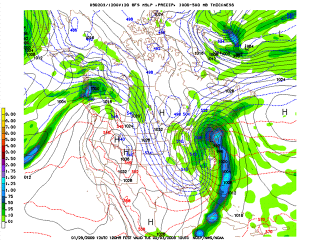
gfs_slp_120m (Small).gif


This is a very ugly picture for all of NE. We need the low to go to Boston or the Cape..
The only saving grace from this track is that there will be substantial back lash and orographic snows.
View attachment 1


By the way all the Euro Models take a similar track :evil:
 

Attachments

  • gfs_slp_138m (Small).gif
    gfs_slp_138m (Small).gif
    89.7 KB · Views: 4,675
The north will get the best of this one. In the south it should switch over to snow. What are the 10 meter maps reading?
 
Rob are you referring to the 850mb temps or 500mb thickness....
this storm pass left of Burlington. It's going to rain on Mt Washington..

How's the belly feeling.. I had the same thing 10ys ago.. lots of fun :roll:
 
jasoncapecod":3g0i5o85 said:
Rob are you referring to the 850mb temps or 500mb thickness....
this storm pass left of Burlington. It's going to rain on Mt Washington..

How's the belly feeling.. I had the same thing 10ys ago.. lots of fun :roll:

Getting better. I'm just praying that by february 21st I have permission by my doctor to go to Whistler. I'm finally eating real food! Man, processed foods just make my stomach feel so bad, it should be illegal to serve that stuff in a hospital. :-&

As far as the maps are concerned it's still early, the snow line at this point is still flexible. It could still creep up from the south further to the east. Lets check the maps in two more days and we'll see what's going to happen. There will definitely be snow anyhow on the backside of the storm so you never know...
 
Ahhh , blame it on me I have a horrible record for VT skiing everytime I decide to head south this type of system appears. This time no different as plan on taking the kids to MRG on the 6th but not if it rains . The snow gods are determined to keep me roaming the back hills of the Laurentians where the powder is steep and deep but the vertical is short. What the heck this weekend looks good for everybody so time to go for it. :)
 
The new gfs 0z and 6z keeps the storm off the coast \:D/ . Lets hope this trend continues!!!!!

The ECMWF does too !!!!!
 
it has to come in as snow- this winter has been a true classic- it cant get ruined now- Jay Peak is in SICK SHAPE right now- have been up there alot training for a trip to Kicking Horse and Revelstoke later in February. The snow is DEEP!!!!!!!!

Keeping snow thoughts for next tuesday none of that other stuff that falls out of the sky (that stuff is meant for spring/summer/fall) :) :)
 
I'm glad to see the Eastward trend in the models, but I don't trust this storm at all - at least not for anything South or East of Northern VT & the Dacks, and I'm still very worried about Northern VT. New England has been very fortunate to avoid a Jan thaw this year, and I have a gut feeling that our number may be up.

That certainly won't stop me from getting out & enjoying the new snow this wknd; in fact, it makes this wknd even that much more important. My son is scheduled for his 1st ski lesson tomorrow (1st time on skis) and I'm keeping my fingers crossed it will go well.
 
we had our jan thaw in late december and our base depths are just now catching up to where they were b4 x-mas in many places. storm could be good. i gotta pick lesley up from the airport in manchester on monday at midnight as she flies in from skiing in montana. i told her of the impending storm and she told me that we may as well just drive north from there for tues/wed/thurs. \:D/ with weeks of vaca time to use (haven't used a single vaca day yet this winter) it may be time to take that day tues.
pray for snow or at least something that'll add to our base depths like a foot or more followed by a bunch of rain, then a deep freeze with more snow would really benefit places like mrg and cannon to get the woods skiable with no worries of hitting stuff.
yee haw-maybe.
rog
 
As of 6:15 Barry Burbank says it will stay weak B/C the storms different components aren't going to come together. SORRY :( :( :( :(
 
Yeah this one is another coastal/southern new england storm. It's been a good year for the catskills, berkshires, and southern vermont. I'm sure Icelantic would also say that Maine and New Hampshire has done well too.
 
Back
Top