J.Spin
New member
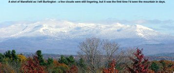
It was great to hear all the reports of people enjoying the new snow on Mt. Mansfield and other Green Mountain locales last week, as the classic upslope flow wrung out moisture from roughly Tuesday through Thursday. The reports of two feet of fresh snow weren?t exaggerations, and it doesn?t take a genius to realize something is going on when the Mt. Mansfield snow depth goes from 4 inches on Monday, to 6 inches on Tuesday, to 17 inches on Wednesday, to 19 inches on Thursday. Since it seems like the numbers from the Mansfield stake often underreport the snowfall due to settling between daily readings, two feet sounded like easy money. With Scott Braaten doing his usual job of forecasting this upslope event well in advance (the first mention I saw was the previous Thursday on SkiVT-L) essentially all you had to do was check your calendar and pencil in a few powder days for the following week. While my preference based on the snowfall would have probably been to schedule in an early morning powder session on Thursday the 26th, work was keeping me pretty busy and I couldn?t get out until Friday afternoon.
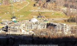
I didn?t reach the base of Mt. Mansfield until after 3:00 P.M., and while the shadows were already starting to grow long, I could still see that there were plenty of skiers about. I?d seen the first vestiges of snowfall at around 1,500? on my drive along the mountain road, and at parking lot level (~1,600?), there was a bit more. Aspect made a big difference in snowline, as the south-facing slopes of the Spruce area were green well up into the heights. With that in mind, I figured the well-shaded terrain of Nosedive would be a good place to search for some unbaked snow.
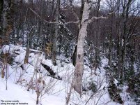
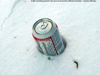
I hiked up past the base of the quad, and while there was enough continuous snow to start skinning right on the north side of the quad base terminal (if one was really eager), the hiking felt good and I decided to hold off with skinning until the hiking became laborious. The beauty of any hike and ski outing is that even if the skiing is horrible, you at least get a hike out of the deal. That?s the way I went into my Friday excursion, figuring that a day?s worth of sun could have really cooked the snow into a chunky mess. I hiked up Lift Line, encountering continuous snow at around 1,800?. I followed someone else?s boot pack (thanks) to make the going a little easier, until at around 1,950? where I encountered a drift that annoyed me a lot in terms of post-holing and I deemed it time for skins. From that point, I continued up by following someone?s down track. It was in this area that I encountered a treat in the form of an unopened can of beer placed in the snow. Someone appeared to have done their karmic duty. I left the can, hoping that it could be used by someone who would appreciate it, and headed on up the slope to begin my crossover to Nosedive. I crossed over via National and the bottom of Goat, realizing too late that I?d have to cut through the woods if I didn?t want to lose vertical. I watched a group of guys working a jump they had made near the National/Goat junction, and then slid my way into the trees. The coverage in the trees was actually fine (for traversing at least). My progress was impeded most by saplings that would normally be covered with a few more feet of snow, and the tricky sloping exit onto Nosedive, but many years? experience of maneuvering through the woods on skis definitely helped the situation.
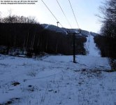
I appeared on Nosedive at around the 2,300? elevation, noticing a couple of guys hiking up from below with their skis, and one hiking up above me. I didn?t know it at the time, but up above me was none other than the upslope forecaster himself, Scott Braaten. Below me was Aaron, another SkiVT-L member, and his friend Paul, as Scott later informed me in an Email. I don?t think Aaron or I had a clue that we were both from SkiVT-L. Although I had my plaid ?SkiVT-L indicator? swatch on my jacket, I?d kept the jacket in my pack during the hike because of the relatively mild temperatures. I worked my way to the skinner?s right of the trail, and continued up behind the lone hiker above me. I was very suspicious about the color of that hiker?s jacket, thinking it reminded me of pictures I?d seen of Scott, but I wasn?t sure. It seemed like a much later time in the day than Scott had mentioned in his Email to SkiVT-L about his planned outing, so I was skeptical. I never did get a chance to catch up to Scott, but at least I got him in one of my photos in the same way I was in one of his.
The afternoon was moving along, and I had to choose a turn around time that left me room to coordinate dinner plans. I picked a spot above me where the lone hiker (Scott) had stopped next to a large tree, and made that my goal. Arriving at my chosen high point, I pulled out my cell phone and tried to raise E. If I could have made contact with her at that point, I might have been able to find out how the evening?s plans were going and if I had more time. Unfortunately, I wasn?t able to reach her, despite a fairly good signal. It turns out my phone had switched to ?extended network? and required an area code to be dialed. D?oh! At least I know that now, so it won?t stand in the way next time. Without making contact, I decided it would be best to head down from where I was. I really wanted to see what the snow was like up higher, but my current elevation would have to be it. My instruments indicated that I was at approximately 2,700?, apparently just short of where Cliff Trail merges with Nosedive.
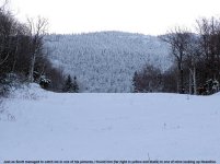
I put my skins away, and chatted for a bit with Aaron and Paul about the ski conditions and climbing skins as they passed. Then, it was time for some turns. I headed over to the skier?s right of Nosedive, which I expected to be the most sheltered from the sun. There, I found about an inch of soft snow on top of the consolidated base. Even the base snow was pretty nice on that aspect and elevation. I could put a good edge into it as needed, without any scraping or slippage. Nosedive had actually been worked pretty well by numerous skiers, so I stuck to the far right strip which still held areas where the soft surface snow hadn?t been disturbed. I had a few turns where I felt like ?Woo! That was awesome!?, but I had to concentrate more and more as I got lower in elevation and the snow became firmer. I decided to just follow Nosedive out to the base, and after taking my skis off to cross the road that the service vehicles had turned to mud, I was able to continue skiing down to the top of the slope above the new gondola house. From there, I walked across to the big flight of stairs above the base lodge, and headed down to the car. I was pleasantly surprised that I could ski just about down to the parking lot, as I thought that option would be gone after Friday?s sunshine. I technically didn?t use ?rock? skis, since my CMH fats are the only ones I?ve outfitted for skinning, but I didn?t hit any rocks, even pushing the run as far as I did. Hooray for grassy slopes. Above about 2,000? in elevation, one really didn?t have to worry about much in terms of coverage. I?d say there was a good 6 to 12 inches of base at that level, nicely settled and with very few gaps except for maybe a deep water bar. To me, it felt like very cool coverage for October.
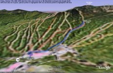
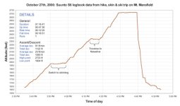
Since I needed a new everyday watch this fall due to issues with my old one, I decided to get the Suunto S6 unit. If I was going to get a new watch, I didn?t want to miss the chance to get one with features for skiing, and Friday was my first chance to try it out on a hike and ski session. The S6 has got all the bells and whistles I can think of in a ski watch, short of the GPS they have in the Suunto X9 unit which isn?t really made for skiing anyway. Like my Avocet ski watch, which I still use as well, the S6 will count your runs and vertical for you during the day, but it also has a nice digital compass that automatically takes care of your declination, an inclinometer, and you can even upload your ski log data to your PC. Being able to make a plot of one?s vertical ski profile is probably even overkill for me (is that possible?) on a typical lift-served ski area day, but it?s definitely something I?d like to include with my backcountry/sidecountry reports. I took my first shot at making a Suunto S6 ski log plot using the data I collected on Friday, and it seemed to work pretty well (the plot is available through the pictures link at the bottom of the report). The Suunto Ski Manager software that comes with the watch will make a nice-looking plot on its own, but I exported my data to Excel for a little more flexibility in this case. I also tracked my outing with my GPS as I?ve done recently. The problem with the GPS method is that sometimes the signal is lost (especially in the trees) and the positioning is off or not present at all. I place the GPS high up on my pack in one of those attachable cell phone pockets to give it good exposure to the sky, but the signal is still lost at times. For Friday?s GPS data, I filled in the gaps and jumpy readings, and after that it seemed to give a fairly good representation of the trip. I imported the GPS track data into Google Earth, and an image of that representation is available on the website with the pictures as well. I think it was SkiVT-L that introduced me to the Google Earth program, and I have to say thanks because it?s just too cool.
There was a lot of concern about rain over the weekend washing away all our great early-season snowpack, but as of Sunday?s reading the snow depth at the stake was up to 21 inches, and as of Monday it had jumped to 24 inches. That?s definitely the highest total I?ve seen so far this fall. I?m not sure how much snow the lower elevations gained over the past few days, but the stake came away with a net gain of snow and that can?t be too bad. Ski trip reports since the weekend seemed to indicate that there were plenty of new powder turns going on, and I didn?t hear much in the way of complaining.
Larger versions of the pictures and data plots from the day are available at:
http://www.jandeproductions.com/2006/27OCT06.html
J.Spin
I didn?t reach the base of Mt. Mansfield until after 3:00 P.M., and while the shadows were already starting to grow long, I could still see that there were plenty of skiers about. I?d seen the first vestiges of snowfall at around 1,500? on my drive along the mountain road, and at parking lot level (~1,600?), there was a bit more. Aspect made a big difference in snowline, as the south-facing slopes of the Spruce area were green well up into the heights. With that in mind, I figured the well-shaded terrain of Nosedive would be a good place to search for some unbaked snow.
I hiked up past the base of the quad, and while there was enough continuous snow to start skinning right on the north side of the quad base terminal (if one was really eager), the hiking felt good and I decided to hold off with skinning until the hiking became laborious. The beauty of any hike and ski outing is that even if the skiing is horrible, you at least get a hike out of the deal. That?s the way I went into my Friday excursion, figuring that a day?s worth of sun could have really cooked the snow into a chunky mess. I hiked up Lift Line, encountering continuous snow at around 1,800?. I followed someone else?s boot pack (thanks) to make the going a little easier, until at around 1,950? where I encountered a drift that annoyed me a lot in terms of post-holing and I deemed it time for skins. From that point, I continued up by following someone?s down track. It was in this area that I encountered a treat in the form of an unopened can of beer placed in the snow. Someone appeared to have done their karmic duty. I left the can, hoping that it could be used by someone who would appreciate it, and headed on up the slope to begin my crossover to Nosedive. I crossed over via National and the bottom of Goat, realizing too late that I?d have to cut through the woods if I didn?t want to lose vertical. I watched a group of guys working a jump they had made near the National/Goat junction, and then slid my way into the trees. The coverage in the trees was actually fine (for traversing at least). My progress was impeded most by saplings that would normally be covered with a few more feet of snow, and the tricky sloping exit onto Nosedive, but many years? experience of maneuvering through the woods on skis definitely helped the situation.
I appeared on Nosedive at around the 2,300? elevation, noticing a couple of guys hiking up from below with their skis, and one hiking up above me. I didn?t know it at the time, but up above me was none other than the upslope forecaster himself, Scott Braaten. Below me was Aaron, another SkiVT-L member, and his friend Paul, as Scott later informed me in an Email. I don?t think Aaron or I had a clue that we were both from SkiVT-L. Although I had my plaid ?SkiVT-L indicator? swatch on my jacket, I?d kept the jacket in my pack during the hike because of the relatively mild temperatures. I worked my way to the skinner?s right of the trail, and continued up behind the lone hiker above me. I was very suspicious about the color of that hiker?s jacket, thinking it reminded me of pictures I?d seen of Scott, but I wasn?t sure. It seemed like a much later time in the day than Scott had mentioned in his Email to SkiVT-L about his planned outing, so I was skeptical. I never did get a chance to catch up to Scott, but at least I got him in one of my photos in the same way I was in one of his.
The afternoon was moving along, and I had to choose a turn around time that left me room to coordinate dinner plans. I picked a spot above me where the lone hiker (Scott) had stopped next to a large tree, and made that my goal. Arriving at my chosen high point, I pulled out my cell phone and tried to raise E. If I could have made contact with her at that point, I might have been able to find out how the evening?s plans were going and if I had more time. Unfortunately, I wasn?t able to reach her, despite a fairly good signal. It turns out my phone had switched to ?extended network? and required an area code to be dialed. D?oh! At least I know that now, so it won?t stand in the way next time. Without making contact, I decided it would be best to head down from where I was. I really wanted to see what the snow was like up higher, but my current elevation would have to be it. My instruments indicated that I was at approximately 2,700?, apparently just short of where Cliff Trail merges with Nosedive.
I put my skins away, and chatted for a bit with Aaron and Paul about the ski conditions and climbing skins as they passed. Then, it was time for some turns. I headed over to the skier?s right of Nosedive, which I expected to be the most sheltered from the sun. There, I found about an inch of soft snow on top of the consolidated base. Even the base snow was pretty nice on that aspect and elevation. I could put a good edge into it as needed, without any scraping or slippage. Nosedive had actually been worked pretty well by numerous skiers, so I stuck to the far right strip which still held areas where the soft surface snow hadn?t been disturbed. I had a few turns where I felt like ?Woo! That was awesome!?, but I had to concentrate more and more as I got lower in elevation and the snow became firmer. I decided to just follow Nosedive out to the base, and after taking my skis off to cross the road that the service vehicles had turned to mud, I was able to continue skiing down to the top of the slope above the new gondola house. From there, I walked across to the big flight of stairs above the base lodge, and headed down to the car. I was pleasantly surprised that I could ski just about down to the parking lot, as I thought that option would be gone after Friday?s sunshine. I technically didn?t use ?rock? skis, since my CMH fats are the only ones I?ve outfitted for skinning, but I didn?t hit any rocks, even pushing the run as far as I did. Hooray for grassy slopes. Above about 2,000? in elevation, one really didn?t have to worry about much in terms of coverage. I?d say there was a good 6 to 12 inches of base at that level, nicely settled and with very few gaps except for maybe a deep water bar. To me, it felt like very cool coverage for October.
Since I needed a new everyday watch this fall due to issues with my old one, I decided to get the Suunto S6 unit. If I was going to get a new watch, I didn?t want to miss the chance to get one with features for skiing, and Friday was my first chance to try it out on a hike and ski session. The S6 has got all the bells and whistles I can think of in a ski watch, short of the GPS they have in the Suunto X9 unit which isn?t really made for skiing anyway. Like my Avocet ski watch, which I still use as well, the S6 will count your runs and vertical for you during the day, but it also has a nice digital compass that automatically takes care of your declination, an inclinometer, and you can even upload your ski log data to your PC. Being able to make a plot of one?s vertical ski profile is probably even overkill for me (is that possible?) on a typical lift-served ski area day, but it?s definitely something I?d like to include with my backcountry/sidecountry reports. I took my first shot at making a Suunto S6 ski log plot using the data I collected on Friday, and it seemed to work pretty well (the plot is available through the pictures link at the bottom of the report). The Suunto Ski Manager software that comes with the watch will make a nice-looking plot on its own, but I exported my data to Excel for a little more flexibility in this case. I also tracked my outing with my GPS as I?ve done recently. The problem with the GPS method is that sometimes the signal is lost (especially in the trees) and the positioning is off or not present at all. I place the GPS high up on my pack in one of those attachable cell phone pockets to give it good exposure to the sky, but the signal is still lost at times. For Friday?s GPS data, I filled in the gaps and jumpy readings, and after that it seemed to give a fairly good representation of the trip. I imported the GPS track data into Google Earth, and an image of that representation is available on the website with the pictures as well. I think it was SkiVT-L that introduced me to the Google Earth program, and I have to say thanks because it?s just too cool.
There was a lot of concern about rain over the weekend washing away all our great early-season snowpack, but as of Sunday?s reading the snow depth at the stake was up to 21 inches, and as of Monday it had jumped to 24 inches. That?s definitely the highest total I?ve seen so far this fall. I?m not sure how much snow the lower elevations gained over the past few days, but the stake came away with a net gain of snow and that can?t be too bad. Ski trip reports since the weekend seemed to indicate that there were plenty of new powder turns going on, and I didn?t hear much in the way of complaining.
Larger versions of the pictures and data plots from the day are available at:
http://www.jandeproductions.com/2006/27OCT06.html
J.Spin