You are using an out of date browser. It may not display this or other websites correctly.
You should upgrade or use an alternative browser.
You should upgrade or use an alternative browser.
Tuesday/Wednesday Storm
- Thread starter yak
- Start date
jasoncapecod
Well-known member
go north my friend
yak
New member
jasoncapecod":22qa83ay said:go north my friend
I was thinking of skinning the dunes at Cahoon Hollow - are you saying that would be a bad idea?

jasoncapecod
Well-known member
:lol: :lol: RT 89
icelanticskier
New member
the wednesday storm could be good. it may be better to go not too far north as has been the case lately. i was thinking stowe but, now don't know. could be a killington jackpot storm. mrg/cannon/kitty/sr could be great, jay may get less.
i'm doin a backcountry day tomorrow and will try to go where it snows for wednesday. a friend skied mrg today and said the conditions were less than ideal, hardpack to ice with wind hammered crap. he said bolton skied really well over the weekend though. i'd love to hit cannon with a good base and new snow, we'll see.
rog
jasoncapecod
Well-known member
HEAVIEST PCPN WILL OCCUR IN ABOUT A 6 HR PERIOD TUES
NITE WHEN ISENTROPIC LIFT IS GREATEST. MID LEVEL WARMING IS
SIGNIFICANT...AND MAY RESULT IN A MIX WITH SLEET/FZRA OVER SRN
ZONES...THE SAME AREA WHERE QPF WILL BE GREATEST.
less mixing the further north.. lite snow is better than moderate that mixes in the end.imho
Personally I'd never underestimate what Jay or Stowe can wring from any disturbance even remotely in the neighborhood.
I'm thinking Gore might do ok. Right now looks like no mixed in N Creek. Can't get there til Friday, but if anyone's going to be there and wants to connect, pm me.
I'm thinking Gore might do ok. Right now looks like no mixed in N Creek. Can't get there til Friday, but if anyone's going to be there and wants to connect, pm me.
icelanticskier
New member
there will definately could be a fine line with north enough for snow but south enough for good accumulation. i'd personally prefer more snow/sleet/sand to pad all of the weekend traffic/wind firm snow than to have less dry snow on firm for a potentially louder bumpier ride. i'm in it for the ride and'll take the spongecake or beachsand almost every time when new depths are less than 10 inches.
we'll hope for the best
rog
we'll hope for the best
rog
Vaportrails
New member
Here's my 2 cents...
Here is the latest for Killington:
Tomorrow (Tuesday): Partly cloudy early followed mostly cloudy skies and a few snow showers later in the day. Cold. High 19F. Winds SW at 5 to 10 mph. Chance of snow 40%.
Tuesday night: Snow in the evening will become heavy at times overnight. Low 14F. Winds ESE at 5 to 10 mph. Chance of snow 80%. Snow accumulating 6 to 10 inches.
Wednesday: Snow likely. High near 30F. Winds SSW at 5 to 10 mph. Chance of snow 80%. Some snow accumulation possible.
My money was on the GIANTS in the Superbowl, and I was right to pick em', so my gut tells me to head North to the Green Mountains... so I'm heading to Killington. This weekend is also supposed to be excellent. Next week's forecast looks like more snow Monday through Wednesday at least so far.
Vaportrails
a.k.a. Anthony
Wayne, NJ
Remember, you're unique... just like everyone else.
yak
New member
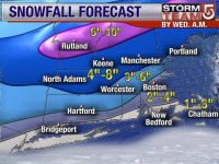
We've settled on K-mart too. It's the easiest drive for me as I have to swing through Springfield on the way out and back, and it looks to be at the southern end of the snow zone on the snow/rain chart that's available (for what that's worth).
I also noticed that the temps are supposed to peak around 3pm, so let's hope that it stays all snow for most of the day.
I also noticed that the temps are supposed to peak around 3pm, so let's hope that it stays all snow for most of the day.
icelanticskier
New member
ooh! closed pico skinning could be deluxe!
rog
rog
Sharon
New member
since I'm stuck here in CNY I am going to ski in the storm tonite at Greek Peak while it is dumping all snow. They are saying 7-9" or so, which skis well here. It ain't Utah, but it's what we have and is more than we've had, so I will take advantage of it any way I can.
This is when night skiing is a great thing.
This is when night skiing is a great thing.
yak
New member
sszycher":18no17l0 said:FYI
this morning's reports seem to be warning us that sleet & freezing rain will mix in further North than what they originally said - which would justify going further North if u can, although I think Killington will ski & ride just fine, even if there's slop mixed in.
I did notice that all the areas are forecasting a temperature peak around 3pm. If that's what brings in the mix, then I can live with that coming late in the day. I believe that most of these weather forecasts are for ground-level and don't take altitude into consideration, so let's hope it's all good on top.
I treated all my gear with a fresh nikwash last night, so I'm ready for some moisture.
jasoncapecod
Well-known member
things aren't looking so good.. significant warming aloft..
Sharon":3vqta5so said:This is when night skiing is a great thing.
Yep, I'm doing the same thing at Camelback tonight.
We're all seeing the models trending warmer. But man the cold looks persistent on the radar, with the pink still south of PA as of now. I'm still holding out for a positive event. Day night timing looks good to me. And true SLEET, if that's what you really get, mixed with a lot of snow, is usually OK or better.
I like my spot on yak's map, just northwest of the purple.
The time for base building is OVER! We want SNOW.
I've got this big window in my office here in downtown rural NJ. It's continuing to snow at 20F. I'm staring at the snow outside thinking that....what usually constitutes a good storm for the southern Adks, starts as snow and turns to rain down here in NJ. This one is holding on!
Why must there be warming aloft?
I know... it's natures way. We need the moisture from the Gulf or the Atl to make magic, and it's warm in those parts. It's the nature of the beast.
Ok, I'll go back to my cave now.
jasoncapecod
Well-known member
Well no matter what happens on Wednesday, I'm digging this picture
--------------------------------------------------------------------------------
snow1_640x480.jpg
Description:
Filesize: 63.25 KB
Viewed: 77 Time(s)
the media will get you everytime..i don't think this forecast is coming true