I've mentioned before experiencing one of those in January 2003; however, 1.5 feet fell the following day.there is a real possibility that it might rain to the top of alta on xmas day. The warm up is impressive
You are using an out of date browser. It may not display this or other websites correctly.
You should upgrade or use an alternative browser.
You should upgrade or use an alternative browser.
Western North America Conditions 2025/26
- Thread starter ChrisC
- Start date
jasoncapecod
Well-known member
not this timeI've mentioned before experiencing one of those in January 2003; however, 1.5 feet fell the following day.
Where are you getting this? AI? OpenSnow Utah forecast one hour ago is here. Current snow Utah level is 9,000+ but storm is mostly farther north so even above 9K it will be 3-6 inches max. The storm this weekend is expected to have snow level 8,000 feet with Utah once again on the southern edge and getting no more than a foot at highest elevations. The snow level is expected to remain at 8,000 feet (Alta's base is 8,500) until Christmas, then start dropping. No numbers are quoted that far out but from the graph below of Alta 8,700 feet you can see it is expected to produce much more snow than the previous marginal storms.there is a real possibility that it might rain to the top of alta on xmas day. The warm up is impressive
In no way do I suggest that Utah skiing is worth even considering before January. Whenever that first big dump happens, snow stability will be awful and it will take days to get terrain open safely.
The issue in Utah is that the November storm was too far south and most of December's too far north. There are indeed many rain horror stories over the past month: Oregon snowfall so far has been a mind-blowing 2 inches at Bachelor and 5 at Mt. Hood, both of which average over 100 by this time. Also not open yet is Brundage (snowave, know if that is a record?). Washington has had more snow than Oregon but so much rain that no one is open and the roads to Crystal and Stevens are damaged. Schweitzer is 1% open. Lookout Pass has had 90 inches of snow but it rained 8 inches last week and damaged the snowpack enough to shut down the area. Even with the continuous storminess in Canada, lower altitudes have gotten a lot of rain. Red Mt. is not open and Fernie only 22% open. The Tetons have been rained upon to 8,500 feet a couple of times this month too. Perhaps it's a blessing that Utah remained dry during those events.
Last edited:
jasoncapecod
Well-known member
Euro and gfsWhere are you getting this? AI? OpenSnow Utah forecast one hour ago is here. Current snow Utah level is 9,000+ but storm is mostly farther north so even above 9K it will be 3-6 inches max. The storm this weekend is expected to have snow level 8,000 feet with Utah once again on the southern edge and getting no more than a foot at highest elevations. The snow level is expected to remain at 8,000 feet (Alta's base is 8,500) until Christmas, then start dropping. No numbers are quoted that far out but from the graph below of Alta 8,700 feet you can see it is expected to produce much more snow than the previous marginal storms.
View attachment 48325
In no way do I suggest that Utah skiing is worth even considering before January. Whenever that first big dump happens, snow stability will be awful and it will take days to get terrain open safely.
Freezing levels are very high
All that said, it still is a week away
Now, and abnormally so. Why would anyone expect them to stay this high for a week at this time of year without a specific forecast predicting that? The predictions say the rain/snow line will be higher than average but below Alta's base by this weekend, which is within the range of credible weather forecasts. Even currently the statementFreezing levels are very high
is bizarre considering the top of Alta is 10,500 and current rain/snow line is 9,000.there is a real possibility that it might rain to the top of alta on xmas day.
are among the sources of that 51 run ensemble graph I posted above.Euro and gfs
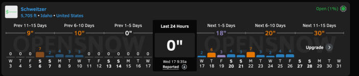
Schweitzer is sitting at ground zero with 1% open now. Mammoth will ski very well with just a couple feet more new snow, though probably needs more than that to open chair 22.
Banff is even better than we discussed last week with 3 feet of snow since then. A 4-5 foot base at those places before Christmas is very rare.
Banff is even better than we discussed last week with 3 feet of snow since then. A 4-5 foot base at those places before Christmas is very rare.
I was planning to ski Red mtn on January 11, prior to Mustang. However its now looking more likely that I will stay further north and ski Lake Louise and Revelstoke. Fortunately, its all the same region, but looks like southern BC has been getting predominantly rain which seems so unusual.Schweitzer is sitting at ground zero with 1% open now. Mammoth will ski very well with just a couple feet more new snow, though probably needs more than that to open chair 22.
Banff is even better than we discussed last week with 3 feet of snow since then. A 4-5 foot base at those places before Christmas is very rare.
claurel
Member
I'm in for a trip to Schweitzer from Jan 1-5 because I have a friend with family in the area. I sure hope it shapes up by then. Banff trips are scheduled for late March and late April — wish those dates were flipped!Schweitzer is sitting at ground zero with 1% open now. Mammoth will ski very well with just a couple feet more new snow, though probably needs more than that to open chair 22.
Banff is even better than we discussed last week with 3 feet of snow since then. A 4-5 foot base at those places before Christmas is very rare.
Last edited:
berkshireskier
Active member
The tram at Jackson Hole is now open, along with the upper two chairlifts - Sublette and Thunder. Looks like still a limited amount of skiable terrain open, though. There is a winter storm warning for the next two days, with up to 2 to 3 feet at elevation. Unfortunately, the prediction is that it may warm up enough that rain will occur on Monday at the lower elevations, at least. But maybe more snow towards Xmas day.
Still looks like the best ski conditions in North America are in the Banff/Lake Louise areas. Quite a bit of snow in the past week or so, with expanding bases and open terrain.
Still looks like the best ski conditions in North America are in the Banff/Lake Louise areas. Quite a bit of snow in the past week or so, with expanding bases and open terrain.
I'm wondering what the point of opening is? Surely it would be easier to save the expense and wait until meaningful terrain can be opened.Schweitzer is 1% open
tseeb
Well-known member
SkiTalk friend who moved from Virginia to Ponderay (near Schweitzer) and is going to Mustang in Feb. when I'll be there (and invited me to stay at his house across the street from Lake Pend Oreille on my way N) said the following in a private email group yesterday:I'm wondering what the point of opening is? Surely it would be easier to save the expense and wait until meaningful terrain can be opened.
"Schweitzer has done much better so far this year, except for Whitefish, than anyone in Inland NW and PNW. Until today, they've been able to keep the one trail open since Dec 3. And for about a week, unofficially open side trails/faces on natural. Closed today due to high wind - it is a wind tunnel at lake level, hate to think how bad it is up at the mountain. I did see Open Snow reported gusts to 100 mph. I don't think anyone in WA or OR had opened, Silver opened a couple trails for one weekend only, Lookout one lift for one weekend only. We've had some snow, but the heavy rains of the past week or so have killed the snowpack.
Good news, weather has turned cold, and snow machine is kicking up. 10 day forecast looks real good, and the snotel has 25" base in the upper 1/3 of the mountain. Pretty much no natural at the base. We won't get anywhere near the 3-4 feet the Cascades will get in the next few days, but they are starting from zero. And our roads are open to reach the resort."
Yes. The Cascades are forecast to get 2-4 feet this week. Colorado is forecast to get snow in its typical modest but more frequent increments. I'd say it's a close call which region gets the majority of its terrain open first. Utah and the Sierra are also in this dubious competition for least terrain open during the upcoming holidays.Colo is going to be quite limited in terrain, but not like the PNW of the US. Though that region is going to get a lot more snow than we will from the next couple of forecast storms.
jimk
Well-known member
One of my Snowbird buddies has been skiing Alta quite a bit in the last week or two. He says there is considerably more terrain acreage open than Snowbird or Solitude. This is not unexpected, as Alta typically does well in early season compared to the others, catching every little bit of snow that comes thru the Wasatch. Alta/Bird is expecting 6-12" of snow this weekend, starting tonight. That could result in a few more trails opening. Snowbird still only has the WROD from Regulator to Big Emma, along with Chickadee. I'm off to San Diego next week for a long planned family gathering. Hopefully, my absence brings a lot of snow 
View of Regulator Johnson and Little Cloud Bowl from 18 Dec 2025, not nearly as white as it's supposed to be:

View of Regulator Johnson and Little Cloud Bowl from 18 Dec 2025, not nearly as white as it's supposed to be:
Alta has more snow and better topography for early season. Base elevation is 8,500 and the lower mountain is mellow on the Albion side and very protected north facing on Wildcat. Relentlessly steep areas like Snowbird need a lot of coverage. Anything under a 50 inch base is a minefield and it really needs 70 for comprehensive coverage. Alta skis remarkably well on 3-4 feet.He says there is considerably more terrain acreage open than Snowbird or Solitude. This is not unexpected, as Alta typically does well in early season compared to the others, catching every little bit of snow that comes thru the Wasatch.
I view the 4 largest Kootenay areas as a group: Red to the NW, Schweitzer to the SW, Fernie to the NE and Whitefish to the SE. They generally get the same weather with two important exceptions:
1. Fernie gets more precipitation than the other 3.
2. Whitefish has slightly higher elevation range than the others and gets less rain. Despite similar elevation maybe Fernie gets a bit less rain than Red and Schweitzer due to being farther inland.
I have never seen as big a disparity between Whitefish and the other 3 before as there is right now. Whitefish reports 47% open vs. Fernie 4%, Red closed and Schweitzer 1%. I'd guess Whitefish like Whistler is drawing some regional people whose home areas are in bad shape.
Whitewater grouped in with those four?I view the 4 largest Kootenay areas as a group: Red to the NW, Schweitzer to the SW, Fernie to the NE and Whitefish to the SE. They generally get the same weather with two important exceptions:
1. Fernie gets more precipitation than the other 3.
2. Whitefish has slightly higher elevation range than the others and gets less rain. Despite similar elevation maybe Fernie gets a bit less rain than Red and Schweitzer due to being farther inland.
I have never seen as big a disparity between Whitefish and the other 3 before as there is right now. Whitefish reports 47% open vs. Fernie 4%, Red closed and Schweitzer 1%. I'd guess Whitefish like Whistler is drawing some regional people whose home areas are in bad shape.