Yosemite at Near Maximum Water Flow, July 1, 2011

Tony Crocker

Administrator
Staff member
I drove with Andrew to Fresno Thursday so we could hike in Yosemite Friday on the way to Mammoth. With the deep snowpack, late spring and just recent warmup I expected very high volume in the waterfalls. We drove to Glacier Point, arriving about 10:30. View of Upper and Lower Yosemite Falls from there:
IMG_9438.JPG


On the east side of Glacier Point Andrew is by the sign looking toward Half Dome and Vernal and Nevada Falls on the Merced River.
IMG_9448.JPG


We started hiking the Panorama Trail toward Nevada Falls. Here's the view of Vernal Falls.
IMG_9450.JPG

The Mist Trail runs along the right side of the rapids below Vernal Falls.

The Panorama Trail first descends 1200 feet from Glacier Point to Illouette Creek. Here's Illouette Falls.
IMG_9457.JPG


Illouette Creek running across granite above the falls.
IMG_9466.JPG


Rainbow from the top of the Illouette Falls.
IMG_9467.JPG


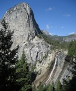
At the halfway point we decided that Andrew would continue on to Nevada and Vernal Falls, then down to the valley floor. A bit below the trail I rested with this view of Nevada Falls.
IMG_9479.JPG


Half Dome and Liberty Cap are on the other side of the Merced River from the Panorama Trail.
IMG_9480.JPG


I went back to Glacier Point and drove into the valley to pick up Andrew. Bridalveil Falls:
IMG_9513.JPG


El Capitan and the infrequently flowing Ribbon Falls:
IMG_9514.JPG


Closer view of the upper part of Ribbon Falls.
IMG_9515.JPG

It's a low volume fall but the tallest in the park at 1600 feet.

The usual view of Upper Yosemite Falls from the valley floor.
IMG_9518.JPG

What's not so usual is its volume.
 
Last edited:
+1 on pictures

For comparison of late summer water flow, see my picture of Nevada Falls taken Sept. 9, 2010 (corrected) on my wife's and my return from hiking Half Dome. She made to the bottom of the cables where she took a nap. I waited about 15 minutes in line to get to the cables and in less than an hour from when picture was taken, I was on top on my first attempt at this 17 mile roundtrip hike.

It was an exceptionaly crowded day as it was a Thursday and permits were required Fri-Sun last year. So if you did not have a permit, you had to go on Thursday or wait until Monday. Plus there was some rain on Wednesday which makes Half Dome slippery and 9/9 is also Admissions day for California, a holiday for some people. There were also a lot of college students on Half Dome as schools on quarter system don't start under later in the month. The cables were clogged by some young ladies wearing Stanford garb that were frozen on the cables, taking a step or two down every few minutes. This year, permits are required seven days a week. A friend is leaving early tomorrow morning and hiking on Sat. We thought about going back this 9/9, but would have to find permits on craigslist as they get reserved months in advance.
 

Attachments

  • 7293CrowdedCablesCR.JPG
    7293CrowdedCablesCR.JPG
    193.7 KB · Views: 4,344
  • 7315NevadaFallsCR.JPG
    7315NevadaFallsCR.JPG
    185 KB · Views: 4,341
jamesdeluxe":2kpvusf8 said:
"Yosemite At Maximum Water Flow of Our Lifetimes?"

I nominate this post as the best reply of our lifetimes?

At least since Les Otten gave his 2 cents on the possibility to post anonymously without logging in. :popcorn:
 
MarcC":pmphe4uh said:
I think that distinction goes to Jan 1997, the year the Merced overflowed its banks and flooded much of the upper valley.
http://www.youtube.com/watch?v=GttPGfZgY2w
Impressive video. There's an occasional glimpse of the top of Yosemite Falls but none of the other ones. I wonder if anyone ever saw Vernal and/or Nevada Falls during that time. Clearly not via the Mist Trail, most of which would have been underwater. Glacier Point's road is closed in winter, though cross country skiers use it. Whether any of them would have tried or been permitted to ski from Badger Pass to Glacier Point during 5 days of torrential rain is another question.

That storm was quite distinctive. It rained to 12,000 feet for the first 3 days, lowered to 7,500 on the last day. I arrived at Mammoth in the middle of the storm: one rain day of no skiing, then one at June when the wind was still too strong, and a last morning at Mammoth. Mammoth got enough snow at the end for skiing to be good, but life was tougher at lower elevations at Tahoe and in SoCal. The Kern River had to be let out of Lake Isabella to prevent its dam from overflowing, so the 19th century Lake Tulare reformed in the southern end of the San Joaquin Valley: http://articles.latimes.com/1997-02-13/ ... ulare-lake
 
Their are a lot of park rangers at these places now and it makes me feel un-easy. Almost like im guilty until proven innocent. Still a beautiful place to visit. Too bad I don't live around here. Nice Pics BTW
 
tenpoun1":iztul8tu said:
Their are a lot of park rangers at these places now and it makes me feel un-easy.
There are less now than 10 and 20 years ago thanks to the severe underfunding of the NPS. I'm not sure what you're complaining about. You'll encounter more police on a walk in mid-town Manhattan or downtown Atlanta than you will in a day in Yosemite.
 
Back
Top