You are using an out of date browser. It may not display this or other websites correctly.
You should upgrade or use an alternative browser.
You should upgrade or use an alternative browser.
Eastern NoAm Weather 2008-09
- Thread starter Harvey
- Start date
Patrick can't say he's not getting enough moral support :lol:

J.Spin
Member
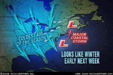
I just noticed this thread, which seems to be the best place to talk about upcoming weather events. With regard to this week's weather, Powderfreak weighed in with his thoughts this morning at SkiVT-L.
J.Spin
J.Spin
Powderfreak was not posting that frequently on FTO last year, so if JSpin or someone else continues to post references to Powderfreak's forecasts like this, I suspect our eastern contingent would much appreciate it. =D>
NWS is calling for a nice little storm for Gore. Hope I don't lose anymore trees. Snow should be pretty wet and heavy.
Weather is beautiful, wish I was there:
Tonight: A chance of drizzle before 8pm, then occasional rain between 8pm and 3am, then snow after 3am. Low around 31. Calm wind becoming north between 7 and 10 mph. Chance of precipitation is 100%. Total nighttime snow accumulation of 1 to 2 inches possible.
Tuesday: Snow. High near 31. Blustery, with a north wind between 17 and 20 mph, with gusts as high as 30 mph. Chance of precipitation is 100%. New snow accumulation of 6 to 10 inches possible.
Tuesday Night: Snow showers, mainly before midnight. Low around 28. Breezy, with a west wind between 15 and 23 mph, with gusts as high as 55 mph. Chance of precipitation is 90%. New snow accumulation of 3 to 5 inches possible.
http://www.grib2.com/wrf/N-EAST_WRF_SFC ... L_48HR.gif
Harvey44":13ow9bl5 said:Weather is beautiful, wish I was there
Weather is here, wish you were beautiful.
(Sorry, I just had to! O
") )
)
Sharon
New member
Tony Crocker":3q0xl1bn said:Powderfreak was not posting that frequently on FTO last year, so if JSpin or someone else continues to post references to Powderfreak's forecasts like this, I suspect our eastern contingent would much appreciate it. =D>
He thinks the Adks are going to get Feet of snow.
Here's his post from yesterday
Now its a day and a half later and all model guidance is in favor of a major
autumnal Nor'easter that will bring significant heavy wet snow to the North
Country on Tuesday night. An anomalous upper level trough will turn
negative as it swings through the Ohio Valley, exciting surface low pressure
development just off the eastern coastline. This low will deepen rapidly in
response to fantastic upper level divergence along the northeastern
coastline. The low will track over extreme eastern New England (BOS) before
getting pulled NNW into southern Quebec as a vertically stacked bomb. The
NAM is the only model that tracks this up the Hudson River Valley (game over
for VT if that happens). I'm discounting this far of a westward track but
if it happens, the Adirondacks take the brunt, not VT. Right now the
GFS/UKMET/CMC/ECMWF are further east, with it coming ashore between Boston
and Portland. This is "Green Mountain Crusher" material (hvy wet snow +
high winds)...I see BTV has mentioned potential tree damage in their AFD
this morning, I think there would likely be some power outages with this
storm.
Liquid equiv totals across northern Vermont will be in excess of 1" with the
western slopes of the northern Greens and Adirondacks potentially seeing up
to 2.5". This is in line with HPC grids and a NAM/GFS blend. Now that both
American models show a very similar solution, I will assume earlier model
differences have been cleared up. The H85 0C line runs north south through
VT before getting sucked up to the NE as the low passes us...so we'll start
as rain and transition to snow.
Timeline.
Rain showers will break out across the area tomorrow morning well in advance
of the actual storm. Rain could become heavy at times for a period tomorrow
afternoon before changing to heavy wet snow at the higher elevations
tomorrow afternoon/evening. Tomorrow evening after sun-down, heavy wet snow
is expected to mix all the way to the valley floor.
Tuesday night will be snow, heavy at times, in all areas of central and
northern Vermont, as well as the eastern Adirondacks. It will also become
very windy as the core of the low level gradient moves through our area.
Winds will start ripping out of the NNW as the storm wraps up. Model track
wants to set-up heaviest deformation band along the western slopes of the
Greens and the Champlain Valley. There is still some time for them to move
this further east or west, but this cold conveyor belt on the backside will
be where the heaviest snowfall ends up. Synoptic snowfall tapers off as
snow showers by Wednesday morning.
Upslope?
Wednesday will see a continuation of snowfall in the upslope areas. If this
does pan out as a closed, vertically stacked low in southern Quebec, we will
have a strong, moist NW flow ripping into the upslope regions for an
extended period of time. I believe Wednesday will see continued appreciable
snowfall along the northern/central Green Mtn upslope regions. This would
also apply to the northern slopes of the Adirondacks. Whether or not we get
additional significant snowfall on Wednesday will depend on just where this
thing slows down in Quebec.
Snowfall.
This morning I've looked at enough guidance that suggests the potential for
8-16" across the higher terrain (above 2,000ft)...4-8" between 1-2K...and
2-4" of 20% density snow in the Champlain Valley.
This is subject to change, naturally, and I'll have final amounts out
tonight. I've got to work till 8 but should have final details out later.
Whatever happens, either the Adirondacks or Green Mountains will receive
heavy snow as there is high confidence in a storm, but only mediocre
confidence in track. 25-50 mile track fluctuations makes a big difference
in early season marginal events.
Get the boards ready.
-Scott
ps: Here's BTV's call to action this morning:
A LOW PRESSURE AREA WILL DEVELOP OFF THE MID ATLANTIC COAST LATE
MONDAY NIGHT AND THEN MOVE NORTHWARD AND BE OVER CAPE COD TUESDAY AFTERNOON.
THIS LOW PRESSURE AREA WILL MOVE INTO MAINE TUESDAY NIGHT AND THEN
INTO QUEBEC ON WEDNESDAY. RAIN WILL DEVELOP OVER THE REGION ON TUESDAY...
BUT WILL CHANGE TO SNOW OVER THE HIGHER ELEVATIONS DURING TUESDAY AFTERNOON
AS COLDER AIR ALOFT MOVES INTO THE REGION. THE SNOW LEVELS WILL GRADUALLY
LOWER BY LATE TUESDAY AFTERNOON AND WILL REACH VALLEY LOCATIONS
EARLY TUESDAY NIGHT. THIS LOW PRESSURE AREA HAS THE POTENTIAL TO BRING
A SIGNIFICANT EARLY SEASON SNOWFALL TO VERMONT AND NORTHERN NEW
YORK LATE TUESDAY AFTERNOON AND TUESDAY NIGHT. SNOW IS EXPECTED TO TAPER
OFF TO SNOW SHOWERS WEDNESDAY MORNING...AND MAY MIX WITH RAIN SHOWERS
OVER VALLEY LOCATIONS ON WEDNESDAY.
.SPOTTER INFORMATION STATEMENT...
SPOTTER ACTIVATION WILL LIKELY BE NEEDED LATE TUESDAY AFTERNOON
AND TUESDAY NIGHT. SPOTTERS ARE REQUESTED TO PROVIDE SNOWFALL REPORTS
TO THE NATIONAL WEATHER SERVICE IN BURLINGTON.
Patrick
Well-known member
AT gear would be very useful right now, Ottawa (yes, the city) is expected to get between 10-15cm Tuesday night. So skiing those molehills 15-20km outside of downtown should be fun.
I was suppose to do a return-trip for a hockey game in Montreal, I might decide to take the bus instead.
I was suppose to do a return-trip for a hockey game in Montreal, I might decide to take the bus instead.
Patrick":3n2hwdjy said:I was suppose to do a return-trip for a hockey game in Montreal
Are you, like, EVER at home? :-k
Hockey games, road trips, solo vacations to the southern hemisphere, several concerts every month... you've got it dialed in.
Sharon
New member
The latest summary from Powderfreak:
Final Snowfall:
Adirondacks...8-16"
Catskills...6-12"
Greens...4-8" @ 1,500ft+, except 6-10" along the immediate spine @ 2,500ft+,
2-4" @ 500-1,500ft.
Champlain Valley...1-2"
- Show quoted text -
-Scott
ps: Saw several 6+ inch reports in the Poconos this morning, even a 10.5"
above 2,000ft down there so far.
J.Spin
Member
Here are this morning's snowfall maps from the BTV NWS for their forecast area. They seem generally in line with Powderfreak's thoughts though their numbers are a bit higher in the Champlain Valley and potentially some of the other lower elevation spots.


000
FXUS61 KBTV 281518
AFDBTV
AREA FORECAST DISCUSSION
NATIONAL WEATHER SERVICE BURLINGTON VT
1118 AM EDT TUE OCT 28 2008
A SIGNIFICANT HEAVY WET SNOW EVENT EXPECTED FOR NORTH COUNTRY WITH
POTENTIAL FOR WIDESPREAD POWER OUTAGES...ESPECIALLY ACROSS
NORTHERN NEW YORK BY WEDNESDAY MORNING.
.SYNOPSIS...
-- Changed Discussion --A LOW PRESSURE SYSTEM NEAR LONG ISLAND WILL MOVE NORTH INTO
CENTRAL NEW ENGLAND TONIGHT. AS PLENTY OF ATLANTIC MOISTURE
INTERACTS WITH COLD AIR...LIGHT RAIN WILL CHANGE TO ALL SNOW BY
THIS EVENING ACROSS NORTHERN NEW YORK. THE RAIN WILL CHANGE TO
SNOW BY LATE THIS EVENING ACROSS CENTRAL AND NORTHERN VERMONT. THE
GREATEST POTENTIAL FOR SIGNIFICANT SNOWFALL ACCUMULATIONS WILL BE
ACROSS NORTHERN NEW YORK...AS WELL AS CENTRAL AND NORTHERN VERMONT
MOUNTAINS BY LATE WEDNESDAY.THE WINTRY PRECIPITATION WILL CONTINUE INTO
WEDNESDAY BEFORE HIGH PRESSURE BUILDS OVER THE AREA THURSDAY INTO
FRIDAY.-- End Changed Discussion --
&&
.NEAR TERM /THROUGH TONIGHT/...
-- Changed Discussion --AS OF 1054 AM EDT TUESDAY...HAVE UPDATED FCST TO INCLUDE SAINT
LAWRENCE RIVER VALLEY INTO WINTER STORM WARNING...FROM 6 PM
TONIGHT THROUGH 2 PM WEDS FOR 6 TO 12 INCHES OF SNOWFALL. SFC
ANALYSIS PLACE 990MB SFC LOW PRES NEAR LONG ISLAND WITH GREATEST
3HR PRES FALLS TWD CENTRAL NEW ENGLAND. BASED ON THIS TRACK AND
POSITION OF DEEP CUTOFF 7H/5H CIRCULATIONS...FEEL WESTERN CWA WL
BE IN FAVORABLE BACKSIDE DEFORMATION ZN FOR HEAVY SNOWFALL. NEXT
QUESTION IS TIMING OF LIGHT RAIN/SNOW CHANGING OVER ACCUMULATING
SNOWFALL. FEEL HEAVY BAND OF RAIN/SNOW ACRS SNE/CENTRAL NY WL
ADVECT INTO OUR FA BY THIS AFTN. THIS HEAVY PRECIP WL HELP TO COOL
COLUMN ENOUGH TO SUPPORT ALL SNOW...ESPECIALLY ACRS THE HIGHER
TRRN OF DACKS. EXPECTED CHANGE OVER WL BE BTWN 3PM-5PM FOR
DACKS...AND BTWN 5-7PM FOR SLV...AND BTWN 8-10 PM FOR GREEN MTNS
AND AROUND MIDNIGHT FOR CPV. BASED ON TRACK FEEL AND LATEST WATER
VAPOR TRENDS...FEEL CENTRAL/EASTERN VT WL BE IN DRY SLOT THIS
EVENING...WITH BEST ACCUMULATING SNOWFALL OCCURRING AFT MIDNIGHT
ASSOCIATED WITH WRAP AROUND MOISTURE. THE GFS/NAM BOTH SHOW BEST
850-700MB FGEN FORCING...BEST DEEP LAYER LIFT/MOISTURE...ALONG
WITH STRONGEST ULVL FORCING TO BE ACRS WESTERN ZNS. IN
ADDITION...FEEL PRECIP WL CHANGE TO SNOW QUICKEST DUE TO THERMAL
PROFILES...THEREFORE UPGRADED ADVISORY TO WARNING FOR SLV. PLEASE
REFER TO LATEST ALBWSWBTV FOR FURTHER INFO ON WINTER STORM.
GIVEN...HEAVY WET NATURE TO EXPECTED SNOWFALL...WIDESPREAD POWER
OUTAGES DUE TO DOWNED TREES AND BRANCHES WL BECMG A PROBLEM LATE
TONIGHT INTO WEDS...ESPECIALLY AS GUSTY NORTH WINDS INCREASE.-- End Changed Discussion --
&&
.SHORT TERM /WEDNESDAY THROUGH THURSDAY/...
AS OF 427 AM EDT TUESDAY...LOW PRESSURE SYSTEM BRINGING WINTRY WX
TO THE AREA WILL SHIFT INTO S QUEBEC BY WED MORNING. THIS WILL
CONTINUE NNW FLOW ACROSS THE AREA...THUES KEEPING WRAP-AROUND
MOISTURE OVER THE AREA. SYSTEM DOES SHIFT A BIT E DURING
WEDNESDAY...ENHANCING CHANCES FOR -SW OVER N VT. STILL EXPECTING
SEVERAL MORE INCHES OF SNOW TO FALL OVER THE AREA AS A RESULT BFR
WINTER WX ADV EXPIRES LATE WED NGT. HIR ELEV HAVE BEST CHANCES FOR
BEST ACCUM IN NC NE VT DUE TO UPSLOPE FLOW. UPPER TROUGH BEHIND
SFC SYSTEM WILL KEEP LINGERING -SW/--SW FOR MUCH OF N ZONES INTO
THURSDAY...DISSIPATING FROM W TO E AS SFC RIDGE BUILDS OVER THE
AREA. TIGHT GRADIENT REMAINS FOR WED SO WILL CONTINUE MENTION OF
GUSTS AROUND 30-40 MPH AT LEAST FOR MORNING/EARLY AFTNOON HRS.
THIS GRADIENT WILL SLACKEN AS RIDGE BUILDS EAST.
Patrick
Well-known member
jamesdeluxe":15u4jkdk said:Are you, like, EVER at home? :-k
Hockey games, road trips, solo vacations to the southern hemisphere, several concerts every month... you've got it dialed in.
:mrgreen: :mrgreen: :mrgreen:
To be fair, this was the ONLY game I managed to find side-by-side seats since they went on sale. Started at the last game in April and moved my way up, one game at a time. I was somewhat concern about it knowing that I already had 3 shows in 8 days (two of them in MTL) and that my streak might be on the line. However Morgane asked last year if we could go see a Montreal Canadiens game...so it's really for her. 8) I still don't know if I'm driving or taking the bus? :-k
My first Montreal game since the forum back in 1996. My second NHL game since 1996.
Concerts? First concerts since this Summer. :wink:
Harvey44":1m9ifk36 said:NWS is calling for a nice little storm for Gore. Hope I don't lose anymore trees. Snow should be pretty wet and heavy.
From NWS for North River:
Overnight: Snow likely. Cloudy, with a low around 31. Breezy, with a west wind between 18 and 20 mph, with gusts as high as 55 mph. Chance of precipitation is 70%. Total nighttime snow accumulation of 4 to 8 inches possible.
This could be a problem with wet snow. Looks like central and upstate is getting pounded. I would be surprised is the 55 mph is underestimated for higher elevations.
How you doing Sharon?
Belleayre wins:
http://forums.alpinezone.com/39963-bell ... -08-a.html
If it keeps up like that this season, we won't have to worry about the snowmaking budget cuts.
:roll:
http://forums.alpinezone.com/39963-bell ... -08-a.html
If it keeps up like that this season, we won't have to worry about the snowmaking budget cuts.
:roll:
A bit off topic as reporting on eastern Canadian weather . Was out spending the day working on clearing Laurentian back country ski trails and can report the snow was boot deep on my hiking boots and this is after Friday's warm temperatures . Unfortunately warming trend moving in next week . Still , it was good to be out in the snow again fueled by a lunch of kid's Halloween candy
Anthony":3pb3tvp1 said:A bit off topic as reporting on eastern Canadian weather...
Anthony...I've proven yet again that Americans can be self-centered and clueless. I've changed the original thread title to reflect my original intent.