Not just the in the open ocean. For example, rogue waves have been confirmed on Lake Superior and are considered one of the more credible theories regarding potential cause(s) of the sinking of the Edmund Fitzgerald in 1975. https://www.lakescientist.com/did-rogue-waves-sink-edmund-fitzgerald/
You are using an out of date browser. It may not display this or other websites correctly.
You should upgrade or use an alternative browser.
You should upgrade or use an alternative browser.
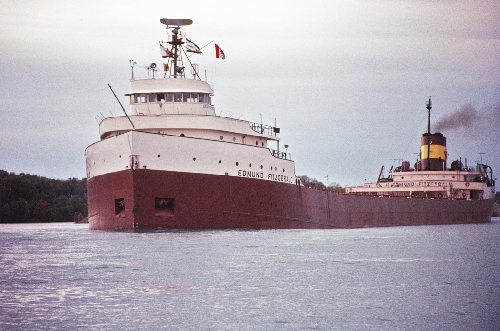
Lake Superior Waves & the Edmund Fitzgerald
- Thread starter flyover
- Start date
jamesdeluxe
Administrator
56-foot-tall waves? That seems hard to believe.the sinking of the Edmund Fitzgerald in 1975
Last edited:
It does seem hard to believe. However, according to the Coastguard Marine Casualty report the seas were up to 25 feet about an hour and 10 minutes before the Fitzgerald disappeared from radar (https://babel.hathitrust.org/cgi/pt?id=mdp.39015071191467&view=1up&seq=48 , at 28) and, according to the wikipedia entry for rogue waves that Tony posted above, the definition of a rogue wave would be roughly a little more than twice that.
Don't underestimate the big lake!
https://www.newsflare.com/video/246...s-in-lake-superior-lashing-coast-during-storm
Don't underestimate the big lake!
https://www.newsflare.com/video/246...s-in-lake-superior-lashing-coast-during-storm
That's an impressive Lake Superior video and I'm surprised it's from the north shore. I'd expect the south shore gets pounded more consistently; likely how the famous sea caves on Devil's Island and near Meyers Beach were formed.
jamesdeluxe
Administrator
I had no idea the Edmund Fitzgerald was that big -- 730 feet long! -- and what it must've taken to sink it. I guess that the common explanation (a huge wave caused it to break in two) is most likely.
Last edited:
That length combined with narrow width (designed for maximum fit in the locks between Lakes Superior and Huron) is a recipe for structural weakness. I read up on the Edmund Fitzgerald, and found out that a ship of its dimensions would never be certified for the open ocean. The Edmund Fitzgerald was exclusively used to haul iron ore from Duluth to Detroit or Toledo.730 feet long
As the designers of the Edmund Fitzgerald may have done.Don't underestimate the big lake!
Last edited:
EMSC
Well-known member
I thought there were also some theories about waves crashing over the middle part of the ship and potentially ripping the covers off the ore compartments, thus adding water weight and ways to rip the middle section apart before eventually breaking it into two.
The great lakes are really kind of mini oceans as much as lakes. The biggest difference being fresh water. Even on the smaller lakes there are some amazing videos of waves, icing up of homes and trees, ice floes pushed op on the shores, etc... Amazing stuff.
The great lakes are really kind of mini oceans as much as lakes. The biggest difference being fresh water. Even on the smaller lakes there are some amazing videos of waves, icing up of homes and trees, ice floes pushed op on the shores, etc... Amazing stuff.
jamesdeluxe
Administrator
I've mentioned before that in the mid-90s I lived in Chicago for four years and always loved the odd feeling of walking or riding alongside an ocean in the middle of the continent. I would've stayed if there had been more interesting terrain for mountain biking and x-c skiing in the surrounding regions. Maybe there was and I wasn't aware of it, given that it was before the internet.The great lakes are really kind of mini oceans as much as lakes.
Last edited:
jamesdeluxe
Administrator
I apparently missed some of the Antarctica reports back then. This one is great.
The polar plunge that you did in the pic above -- how shockingly cold is it when you hit the water? Growing up in Central NY, I used to jump in our backyard pool after it had thawed out in April (in the high 40s, frigid but tolerable); however, I'd be afraid of having a heart attack in water that maintains icebergs.
The polar plunge that you did in the pic above -- how shockingly cold is it when you hit the water? Growing up in Central NY, I used to jump in our backyard pool after it had thawed out in April (in the high 40s, frigid but tolerable); however, I'd be afraid of having a heart attack in water that maintains icebergs.
I think the ocean water was supposed to be 29F. IMHO the real effect of cold water is not immediate upon entry but over time (how long it takes to induce hypothermia symptoms). That can be 15-20 minutes in SoCal ocean water, but in the polar plunge it's more like a few seconds. I wouldn't call it a huge shock as I dived in, but as soon as I surfaced there was no doubt I needed to get out of there ASAP.
Presumably that's why Quark's protocol is to attach a leash to polar plungers. But we skiers were having none of that.I'd be afraid of having a heart attack in water that maintains icebergs.
jamesdeluxe
Administrator
Since going on a trip like this is likely not in the cards for me, some naive questions: is this the type of general liability waiver you sign? Is there additional specific language calling out each of the voluntary activities like the polar plunge? What would've happened if one of the participants had an adverse reaction to jumping in the 28-degree water, where a heli rescue is obviously out of the question?Quark's protocol is to attach a leash to polar plungers. But we skiers were having none of that.
Liz and I sign that type of waiver many times, most obviously for cat skiing in Canada. I'd be astounded if a travel company could be held liable for a polar plunge accident in international waters. The sweeping language in James' reference is quite typical.
We were required to have emergency medical/evacuation insurance. In 2011 Quark and Ice Axe considered our $100K policy sufficient. For a serious medical emergency in along the Antarctic peninsula, you must take your ship to King George Island in the Shetlands, where there is an airstrip for evacuation to South America. IIRC someone on our cruise said there was a medical evacuation from King George Island during the first Ice Axe trip in 2009.
For next April's cruise off NW Australia, they want $1 million insurance, so we had to buy their supplement for that. I can't argue with that. Most of these remote area cruises skew heavily towards retirees due to the time and expense involved. The Ice Axe expeditions are a rare demographic for this type of trip.
I voluntarily and personally assume the risk of any and all consequences of my travel..........I expressly waive my right and the right of any of my heirs, legal representatives and assigns to sue or otherwise collect damages of any kind..........resulting from any cause whatsoever including but not limited to sickness, personal injury, property damage, delay, and change of schedule, wrongful death, theft or loss of property.
We were required to have emergency medical/evacuation insurance. In 2011 Quark and Ice Axe considered our $100K policy sufficient. For a serious medical emergency in along the Antarctic peninsula, you must take your ship to King George Island in the Shetlands, where there is an airstrip for evacuation to South America. IIRC someone on our cruise said there was a medical evacuation from King George Island during the first Ice Axe trip in 2009.
For next April's cruise off NW Australia, they want $1 million insurance, so we had to buy their supplement for that. I can't argue with that. Most of these remote area cruises skew heavily towards retirees due to the time and expense involved. The Ice Axe expeditions are a rare demographic for this type of trip.
The north shore gets plenty of big waves. The difference is the geology. The Bayfield Peninsula is sandstone. The north shore is on the southern fringes of the Canadian Shield and generally much harder rock.That's an impressive Lake Superior video and I'm surprised it's from the north shore. I'd expect the south shore gets pounded more consistently; likely how the famous sea caves on Devil's Island and near Meyers Beach were formed.
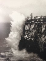
Below is a historical photo, from the museum at the Split Rock lighthouse, of the site of the lighthouse before it was built in 1910. The cliff is 133 feet.
Here are a couple of my pics of the lighthouse. My daughter is under the water in the first photo.
This is true, but only on the open ocean where the distance between waves can be much longer than is possible on the Great Lakes. The Fitz was roughly 10:1. The 13 thousand-footer ore boats that currently sail the great lakes are also roughly 10:1. (They are dedicated lake freighters and are too long to get out the SLS locks.)That length combined with narrow width (designed for maximum fit in the locks between Lakes Superior and Huron) is a recipe for structural weakness.
"Since Great Lakes waves do not achieve the great length or period of ocean waves, particularly compared to the waves' height, ships are in less danger of being suspended between two waves and breaking, so the ratio between the ship's length, beam and its depth can be larger than that of an ocean-going ship. The lake vessels generally have a 10:1 length to beam ratio, whereas ocean vessels are typically 7:1." https://en.wikipedia.org/wiki/Lake_freighter#Design
After she sank, real concerns were raised about the seaworthiness of the Fitz, but they were not related to the length:beam ratio. https://en.wikipedia.org/wiki/SS_Edmund_Fitzgerald#Possible_contributing_factors
Yes, although the USCG's initial conclusion in 1977 that ineffective hatch closure likely contributed to the sinking was largely discredited by the 1978 NTSB findings. https://en.wikipedia.org/wiki/SS_Edmund_Fitzgerald#Cargo-hold_flooding_hypothesisI thought there were also some theories about waves crashing over the middle part of the ship and potentially ripping the covers off the ore compartments, thus adding water weight and ways to rip the middle section apart before eventually breaking it into two.
The great lakes are really kind of mini oceans as much as lakes.
I lived in Chicago for four years and always loved the odd feeling of walking or riding alongside an ocean in the middle of the continent.
Superior, at least, really does feel oceanic to me. I spent a few days on the coast of Maine in early November. Of course the tides, the salt smell, and the seafood made for a different experience, but I was surprised how familiar it felt.
Here's a few pics from Minnesota's north shore:
Sorry about the thread drift.
Attachments
jamesdeluxe
Administrator
Liz and I have pictures like the ones above from our visit to Grand Marias Sept. 3-4, 2020.
Last edited:
jamesdeluxe
Administrator
Grand Marais means "big swamp" in French. I assume that refers to the harbor?
They might have split up or they might have capsized. They may have broke deep and took water.credible theories regarding potential cause(s) of the sinking of the Edmund Fitzgerald in 1975
Back in the 90s and early aughts I spent a lot of my winter weekends on Superior’s south shore skinning around with friends in MI’s “Porcupine Mountains” or out on the Keweenaw, and a lot of my spring weekends whitewater kayaking the rivers of the south shore with the spring runoff. At the end of the day, we would often drop into some local bar for beers and a burger. If there was a jukebox, that song was often on it. However, it was understood to be an unwritten rule that it should not be played unless the person playing the song had cause to play it, i.e., had some connection to one of the crew, many of whom were from the south shore.They might have split up or they might have capsized. They may have broke deep and took water.