My last-minute request for a vacation day granted, I had the pleasure of skiing Wednesday with one of the area's best skiers-hikers-bikers-runners-paddlers. After a 2nd place finish on Saturday in the F.O.T. Inferno pentathlon, she had recovered by Wednesday and wanted more!
FOT 2008 Inferno Results
Skies were mostly sunny in the morning, with increasing clouds afternoon, light winds out of the West-Northwest, highs of 70F-80F in the valleys. At 5AM, the summit was at 42F, so the snow had not set up much overnight, and the snowcover is receding fast. The OBS record high for the date, set at 50F last April, was broken with a new high of 51F.
We stopped for coffee at the White Mountain Cafe in Gorham on our way to Pinkham Notch, Wednesday morning.
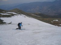
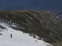
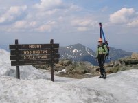
Skiing up, we gave up quickly on the Sherbie, and had continuous snow cover up the Tucks Trail to Hojos. Right Gully was really ugly at the top, climbing over undermined snow, then rocks; it's not really a viable route to the summit any longer. Took us a while to get to the summit. Skinned up a little way above Tuckerman Junction, then hiked the Tucks Trail the rest of the way.
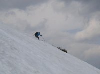
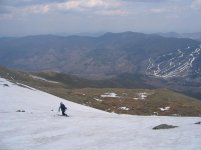
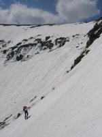
We were able to ski down the East Snowfields, and link that with a big traverse to descend the Chute. Although the Chute was very wide (25'-30'?)at the bottleneck, four deep runnels split it into four narrow skiable lines, and you had to jump over the deep runnels a few times to make it down. We should have gone up to Left Gully or Hillmans for a better ski descent, but it was getting late, and I hadn't skied the Chute in years.
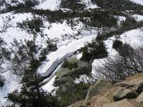
After a short walk across the rocks at the Connection Cache, we skied down the Cutler River (in spite of the hazards), and took skier's right around the big open waterfall on the Little Headwall, where we traversed the Lower Snowfields to bottom of Hillmans, and down to the Sherburne (via a visit to HoJos to see Chris).
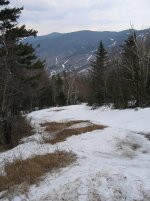
Bare sections on the Sherburne began immediately after the crossover to Tucks Trail at the Cutler River bridge. The old narrow track through the woods on skier's left got us around the first bare stretch, and down to the upper first aid cache. Below there began a series of nice soft bumps interrupted by increasingly frequent walks, until a mere ribbon of snow remained on the edge. We finished on skis, though, from the last bridge to the parking lot.
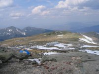
The snow is going very fast. Mike P.'s remark on Wednesday April 16 that we'll be "skiing until June" seemed quite possible at the time, but not any longer. Chris of MWSP had just come up the Auto Road, and told us it looks like the icefall melted out in Pipeline (I had just skied over it on Sat. 4/16)
FOT 2008 Inferno Results
Skies were mostly sunny in the morning, with increasing clouds afternoon, light winds out of the West-Northwest, highs of 70F-80F in the valleys. At 5AM, the summit was at 42F, so the snow had not set up much overnight, and the snowcover is receding fast. The OBS record high for the date, set at 50F last April, was broken with a new high of 51F.
We stopped for coffee at the White Mountain Cafe in Gorham on our way to Pinkham Notch, Wednesday morning.
Skiing up, we gave up quickly on the Sherbie, and had continuous snow cover up the Tucks Trail to Hojos. Right Gully was really ugly at the top, climbing over undermined snow, then rocks; it's not really a viable route to the summit any longer. Took us a while to get to the summit. Skinned up a little way above Tuckerman Junction, then hiked the Tucks Trail the rest of the way.
We were able to ski down the East Snowfields, and link that with a big traverse to descend the Chute. Although the Chute was very wide (25'-30'?)at the bottleneck, four deep runnels split it into four narrow skiable lines, and you had to jump over the deep runnels a few times to make it down. We should have gone up to Left Gully or Hillmans for a better ski descent, but it was getting late, and I hadn't skied the Chute in years.
After a short walk across the rocks at the Connection Cache, we skied down the Cutler River (in spite of the hazards), and took skier's right around the big open waterfall on the Little Headwall, where we traversed the Lower Snowfields to bottom of Hillmans, and down to the Sherburne (via a visit to HoJos to see Chris).
Bare sections on the Sherburne began immediately after the crossover to Tucks Trail at the Cutler River bridge. The old narrow track through the woods on skier's left got us around the first bare stretch, and down to the upper first aid cache. Below there began a series of nice soft bumps interrupted by increasingly frequent walks, until a mere ribbon of snow remained on the edge. We finished on skis, though, from the last bridge to the parking lot.
The snow is going very fast. Mike P.'s remark on Wednesday April 16 that we'll be "skiing until June" seemed quite possible at the time, but not any longer. Chris of MWSP had just come up the Auto Road, and told us it looks like the icefall melted out in Pipeline (I had just skied over it on Sat. 4/16)
Attachments
-
 _IMG_2756SherbieBareSpots.jpg62.8 KB · Views: 6,895
 -
 _IMG_2745EastSnwflds.jpg20.8 KB · Views: 6,844
 -
 _IMG_2739EastSnwflds.jpg38.7 KB · Views: 6,813
 -
 _IMG_2738EastSnwflds.jpg39.4 KB · Views: 6,891
 -
 _IMG_2724SkinAboveLionsHead.jpg46.2 KB · Views: 6,846
 -
 _IMG_2718_SkinUpToRightGully.jpg45.9 KB · Views: 6,883
 -
 _IMG_2716_CnctnCache.jpg66.9 KB · Views: 6,851
 -
 _IMG_2712LtlHdwl.JPG105 KB · Views: 6,833

") , instead of mushy. Maybe you haven't been out enough?
, instead of mushy. Maybe you haven't been out enough?") I hit more mush than corn up there so I have not been up there on the good corn days. Good skiing regardless though!
I hit more mush than corn up there so I have not been up there on the good corn days. Good skiing regardless though!