Western Weather 2017-18 and Later

Spring fell well below expectations for Utah skiing. Jim Steenburgh reported this as SLC's warmest May on record.

I estimate a measly 5 inches of May snow at the Snowbird SNOTEL near mid-Gad vs. 65 inches in May 2011 and 46 inches in May 2019, the last times Snowbird was open for July 4. Snowbird closed for tram maintenance after Memorial Day, promising to open weekends starting June 17-18. Reports from last weekend indicate no skiing in Mineral Basin or on Regulator. Only a constrained sector of Little Cloud was skiable. So last weekend was the end for Snowbird.

For how long a snowpack lasts into summer, its water content is more important than the snowfall total. Alta's 903 inch snowfall had 70 inches SWE. Mammoth's 715 inch snowfall had 87 inches SWE.

From this and past late seasons I've suspected that once you get into true summer mode, Utah and Colorado mountains are warmer than the Sierra. So I looked up the past month's temperatures at the Snowbird SNOTEL vs. Virginia Lakes 9,400 feet, which is off Hwy 395 an hour north of Mammoth. Daytime highs averaged 2.2F warmer and nighttime lows 6.5F warmer at Snowbird than at Virginia Lakes. During that month Virginia Lakes' snowpack melted from 37 inches SWE down to 14 inches while Snowbird's melted from 47 inches SWE down to 2 inches.
 
Last edited:
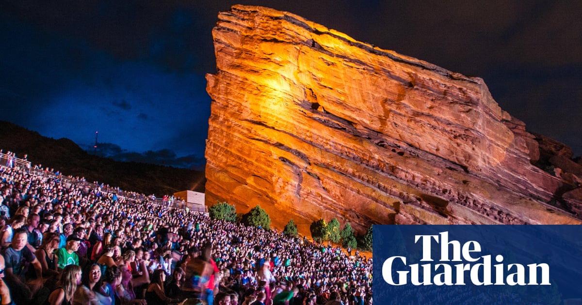
People tend to not recognize turning points or extreme events until it is literally upon them (be it weather, stock market/economy, etc...).

Probably my favorite clip of red rocks:

So going from the clip James posted to THAT ~10 minutes later....

Not sure if everyone knows about archive.is web functionality; but an easy way to see paywalled news articles. Go to the archive.is website, input a url, and ~3-5 minutes later can read it (some are already archived if it's a few days old).

Twitter vids/pics in Denver Post from past two days.
 
People tend to not recognize turning points or extreme events until it is literally upon them (be it weather, stock market/economy, etc...).
Agreed. Golf courses immediately sound air horns whenever there's lightning nearby so players can find shelter -- the last time that happened to me was at Evergreen GC near Denver/we were playing again 20 minutes later. Hard to believe that a trophy venue like RR didn't immediately tell people to beat it.
 
Forgot to mention -- part of the reason I've commented several times on the Red Rocks storm is that I know what it's like to be at a concert there during inclement weather!

As a CU student, I attended the famous U2 concert 40 years ago (June 5, 1983) that became the Under A Blood Red Sky album and video, which propelled the group into superstardom. It rained hard most of the day (no lightning luckily) and they probably would've cancelled if the band hadn't already spent considerable production money on the shoot. As you can see in the clip, by showtime it had cleared up enough for them to perform. Funny to see Bono's big bad mullet and The Edge pre-skullcap!

 
Perhaps James and EMSC would have had a different view than I did of the Cruel World interruption in Pasadena on May 20.

I'm sure I'm complacent about lightning due to its rarity in coastal California. During summer 2020 Liz and I often floated in the Gulf at sunset watching the natural light shows to the north over Clearwater or to the south over St. Petersburg. Reputedly the Tampa Bay area in summer has one of the highest frequencies in the world for thunderstorms. During summer 2020 they consistently missed us to the north or south. We had more rain during the last week of June 2021 than during the 11 weeks I was there in 2020.

My skepticism at Cruel World was based upon my 65 years of living in the area. I would not be skeptical in a location like Red Rocks.
 
Perhaps James and EMSC would have had a different view than I did of the Cruel World interruption in Pasadena on May 20.
Of course lightning can be deadly no matter where. But seems like a delay might have been the better call for that one (likely to dissipate quickly) vs cancellation.

We've had rain-forest weather since Friday
(Crosses fingers that the next 2 weeks are wet for the east so it can dry back out for mid-July).

Interestingly exact opposite here. Dryed out over the weekend and warmed up closer to normal (but still below). Today's forecast is the first with warmer than normal temps (by only a few degrees, but by comparison will feel scorching) in a long time which seems odd considering the heat wave just south of us in Texas.

Another note of how wet it has been here... I just turned on the sprinkler system for the year last night in anticipation of finally getting warm temps this week (well, 3-4 days of warm and dry before it cools back down well below normal).
 
But seems like a delay might have been the better call for that one (likely to dissipate quickly) vs cancellation.
This is complicated by the residential areas surrounding the Rose Bowl demanding an 11PM curfew for events there.
 
And there we have it: more than annual average precipitation by June 30. Wettest first 6 months since 1967.

Average annual: 14.3
2023 YTD Jun 30: 14.42

It sure helped that June had > 3x normal at 6.10" of precip (and by far the wettest ever June by >1"); also the 6th wettest monthly total ever recorded in Denver.

Now if we can only get that type of water into the mtns during winter.

KDEN2023plot.png
 
This is actually the 2nd snow in the central mtns so far in Sept. Roughly same altitude as far as I can tell going down to nearly 11,000 feet. Forecast is for it to warm right back up for the next ~week before cooling off again.
abasincam5.jpg
 
Snowmaking begins at Abasin. Or at least testing the system in 25F air. A couple weeks earlier than recent years.

Al's blog
 
Last edited:
Surprised nobody posted tracks made by snowboarders. https://www.mammothsnowman.com/ captioned it "10-2-23 – First Tracks of the Season on Cornice Bowl". The deeper snow with tracks in center, and in shadier areas to left and right of Cornice, is from last Winter.
IMG_8375.png

I was out of town, but my weather station said we received 0.12 inch of rain on last Saturday, 9/30, the last day of our rainfall year.
 
The deeper snow with tracks in center, and in shadier areas to left and right of Cornice, is from last Winter.
Somewhere I read they ran a groomer up that section of Cornice to preserve the snowpack. Some of the other Snowman pics in that link looks like there are still bands of old snow/ice at the top of Climax and Dave's Run. This occurred in 2017 also and when the ensuing season started slow those ice bands delayed opening of those runs. Cornice rates to get a fast opening this fall with snowmaking over that leftover snowpack though.
 
Off and on over the past week I've been redoing my El Nino analysis webpages. For 20+ years I've been using the Multivariate ENSO Index, but in recent years there's been a convergence of most meteorologists upon the more straightforward Oceanic Nino Index. So this week I converted my webpages to rely primarily upon the latter. Since 1950 monthly ONI is 88% correlated to monthly MEI and ski season values are 94% correlated. The relationship of ski area snowfall to El Nino/La Nina is essentially the same for both MEI and ONI, so there are no meaningful changes to my analyses or classifications of ski areas.

The two indices have diverged often since summer 2002 when La Nina remained consistent by ONI while strengthening by MEI. The La Nina dissipated by early spring for both but as of October 2023 has swung to moderate El Nino+1.5 by ONI but only weak El Nino +0.4 by MEI. The current 1.1 divergence is very rare, that much during only 2% of months since 1950. The warmth of the eastern equatorial Pacific water is tracked by ONI. MEI incorporates other factors like wind, air pressure, which usually change in concert with the water temperature but are not doing so yet this time. Therefore I'm reluctant so far to jump on the bandwagon of expecting strong El Nino impacts upon our upcoming North America ski season.
 
Last edited:
Off and on over the past week I've been redoing my El Nino analysis webpages. For 20+ years I've been using the Multivariate ENSO Index, but in recent years there's been a convergence of most meteorologists upon the more straightforward Oceanic Nino Index. So this week I converted my webpages to rely primarily upon the latter. Since 1950 monthly ONI is 88% correlated to monthly MEI and ski season values are 94% correlated. The relationship of ski area snowfall to El Nino/La Nina is essentially the same for both MEI and ONI, so there are no meaningful changes to my analyses or classifications of ski areas.

The two indices have diverged often since summer 2002 when La Nina remained consistent by ONI while strengthening by MEI. The La Nina dissipated by early spring for both but as of October 2023 has swung to moderate El Nino+1.5 by ONI but only weak El Nino +0.3 by MEI. The current 1.2 divergence is very rare, that much during only 2% of months since 1950. The warmth of the eastern equatorial Pacific water is tracked by ONI. MEI incorporates other factors like wind, air pressure, which usually change in concert with the water temperature but are not doing so yet this time. Therefore I'm reluctant so far to jump on the bandwagon of expecting strong El Nino impacts upon our upcoming North America ski season.
holy cow, I had to send this to my daughter who has a Masters from MIT, so she can translate it..LOL
 
Back
Top