Eastern NoAm Weather 2008-09

This weekend is shot.. With a significant surge of warm air Saturday and Sunday.
Next weeks things start to look much better. With a building Greenland Block the South Eastern ridge end. \:D/
There is also a chance for a decent system to affect us towards the middle and end of next week (fingers crossed)
 
jasoncapecod":3me54fyt said:
This weekend is shot.. With a significant surge of warm air Saturday and Sunday.
Next weeks things start to look much better. With a building Greenland Block the South Eastern ridge end. \:D/
There is also a chance for a decent system to affect us towards the middle and end of next week (fingers crossed)

Whattya mean "this weekend is shot"???

I think it is going to be a great opportunity for spring conditions.

The powder is already changed. I xc skied last night and it was still powdery, but this morning I took the dogs out for a ski and the snow had gotten stiff and sticky. I will ski again this afternoon, though I'm expecting it to be rough, but skiable. I'm just happy to get in some skiing in my backyard.

Snow showers tonight (hopefully) and colder weather tomorrow. Will be skiing at Greek Peak with Jonathan Shefftz (if you can believe it...it's true) tomorrow and maybe on Saturday as well.
 
Can report that areas from Montreal and heading north of the St Lawrence all snow , about 7 inches so far . Just finished shoveling out our hockey rink . My next chance on hitting the hills will be on the 26th . Snow depths north of the St . Lawrence now average about 4 ' at a elevation under 2000' . Bring it on =D>
 
Anthony":86ustrzr said:
Can report that areas from Montreal and heading north of the St Lawrence all snow , about 7 inches so far . Just finished shoveling out our hockey rink . My next chance on hitting the hills will be on the 26th . Snow depths north of the St . Lawrence now average about 4 ' at a elevation under 2000' . Bring it on =D>

Ottawa got snow until 1pm...now it's light freezing drizzle. :? Not sure what is happening in the Gatineaus or Laurentians. I'm also out of commission until the 26th.
 
The winds are howling and the Grinch has roared in from Mt. Crumpet and taken all the new snow and soaked it with rain . No powder left in Whooville . :(
 
Anthony":2kt7358w said:
The winds are howling and the Grinch has roared in from Mt. Crumpet and taken all the new snow and soaked it with rain . No powder left in Whooville . :(

Merry Christmas anyways... Santa has just finished putting the gifts under the tree, T- 7hrs (I hope) before the kids wake up. :roll: :? I asked Santa for a repeat of last season, he said he was going to talk to Ullr about it.
 
Now that's the spirit and remember the Grinch turns out to be a good guy in the end so hoping the snow returns and to all a good night :)
 
Found this buried in the ALB NWS long term. It's all I got right now:

.LONG TERM /MONDAY THROUGH THURSDAY/...

THE HIGH DOMINATES OUR WEATHER FOR NEW YEARS DAY...WITH A THIN SHROUD OF HIGH CLOUDS...A CHANCE OF SNOW SHOWERS DOWNWIND FROM LAKE ONTARIO...AND HIGHS IN THE LOW 30S. THE CLOUDS ARE AHEAD OF A FRONTAL SYSTEM THAT WILL APPROACH THE REGION THE END OF THE WEEK AND BRING SNOW TO THE REGION THE FOLLOWING WEEKEND.
 
wo Systems of Interest for the first half of the week:

1) A weak disturbance tracking through southern Canada will bring snow showers to the North Country on Monday night. This is a very moisture starved system so I'm not looking for anything more than a dusting to 2" across the mountains. I think the Champlain Valley will get downsloped on WSW winds and with a moisture starved system, flakes will probably not make it to the surface.

2) A robust and energetic clipper will track across NY state into central/southern New England on New Year's Eve. This will make for a festive New Year's Eve day across the North Country and I'm pretty set on a widespread 3-6" fluffy snowfall across the entire region. Model QPF has been consistently .25-.5" north of the relatively strong clipper (~998mb and deepening). With the region in the left front quad of a 200mb-300mb speed max and a decent H5 vort tracking over us, we'll have upper air support. Heaviest snow axis looks to be from Watertown-Montpelier-Bangor. The only catch with this one is that if it continues to trend stronger, it'll dig deeper which could put max snowfall further south and bring the 1-3" range into the northern half of our area. Snow should be out of here by the time for festivities but it'll be nice to get a resurfacing of the powder to add to the New Year's cheer.

One Major System Looming for the Weekend:

Global models continue to indicated a strong short-wave will drop into the northern Plains on Thursday and continue ESE into the southern Lakes region. With such a strong shortwave and some moderate upstream blocking, the upper level trough is forced to dig into the Ohio Valley.

Synoptically, what happens from here is based on the strength of the SE Atlantic ridge and upstream blocking as we are developing a -NAO signal. There's the chance that this takes an inland track with snow going to mixed precipitation in our neck of the woods, but there's also the chance that the upper level trough is forced far enough east to spawn a coastal low.

Its a 50/50% chance of either solution right now but global teleconnections are supporting enough of a block that this low tracks east of us, not west. The problem lies with the primary low in the eastern Lakes region, if it hangs on for too long it'll allow warmer air aloft to work into our area. Meanwhile, if you like model nrop, the 00z EURO put a 966mb(!) low near eastern Maine and would be a blizzard for someone in northern New England. Canadian GGEM likes the warmer solution with mainly mixed precip and the GFS is somewhere in between.

Either way, this is looking like a significant precipitation event and will be monitored.

-Scott
 
Boys in Albany seem to agree:

AREA FORECAST DISCUSSION
NATIONAL WEATHER SERVICE ALBANY NY
435 PM EST SUN DEC 28 2008

A CLIPPER LIKE SYSTEM WILL MOVE SOUTHEAST ACROSS SOUTHERN QUEBEC MONDAY NIGHT. MOISTURE IS LIMITED WITH THIS SYSTEM...

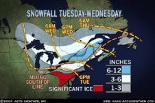
ANOTHER SYSTEM WILL MOVE EAST INTO THE REGION TUESDAY NIGHT AND DEPART THE REGION WEDNESDAY. THIS ONE WILL BE A MORE SIGNIFICANT SYSTEM. AT THIS POINT...THE MAIN FORECAST DILEMNA IS THE STORM TRACK....COULD SEE 2 TO 5 INCHES OF SNOW ACROSS THE REGION WITH THIS EVENT

THE NEXT FORECAST ISSUE WILL BE A STORM FOR BEGINNING SOMETIME FRIDAY MORNING AND INTO THE FIRST PORTION OF THE WEEKEND. THE LATEST GFS SHOW THIS SYSTEM BOTH NORTHERN AND SOUTHERN STREAM ENERGY PHASING ACROSS PA...

AT THIS POINT...AM PLAYING THE STORM AS HIGH CHC POPS FOR MUCH OF THE REGION...WITH LIKELY POPS IN THE FAR SOUTHEASTERN AREAS...AND WILL KEEP P-TYPES AS SNOW FOR THE NORTH...AND A MIX FOR CENTRAL AND SOUTHERN AREAS.
 
Should be a good one for most of us. Weekend may have more. Big problem is getting my a$$ up there. WIBWIWT.
 

Attachments

  • iws0_430-1.jpg
    iws0_430-1.jpg
    31.3 KB · Views: 3,778
jasoncapecod":qpssv97a said:
this isn't a really big event... big time cold may be in out future...

See...I'm thinkin maybe it is a big event. Maybe not in total inches.

Last weekend at Gore...with the wind filling in the troughs and the five inches we got on Friday night...folks on rented gear and others who weren't concerned about bottoming out here and there...were in the trees.

That's a sign to me that another foot and we are back in business for real. I don't think a foot by Sat am is out of the question.

I'm with Rog...I'm thinkin it's time to pack up the truck.
 
the 12z gfs is showing the 546 thickness line going way north.. looks like sleet to me
gfs_slp_030m (Small) (2).gif


notice that line goes to the Canadian boarder.. granted the next map does show some cooling aloft
 
Back
Top