Editor’s Note: This is a weekly column written by Meteorologist Joel Gratz that will take you “behind the scenes” of the typical weather forecast. Joel is the founder of ColoradoPowderForecast.com, where you can sign up for his email alerts.
Boulder, CO – Sometimes meteorologists take shortcuts, and I’m not talking about the slights of tongue that somehow push the words “chance,” “might” and “possible” into every forecast.nInstead of individually tracking each up and down wiggle of the jet stream as it crosses the Pacific Ocean and hits the west coast of the U.S., some very smart folks aggregated all the data and found two distinct patterns of up and down wiggles.
The Pacific North American (PNA) pattern describes the general storm track through the north Pacific and into the United States. When the PNA is positive (+), warmer than average temperatures cover the western U.S. while colder than average temperatures cover the Pacific Ocean and the eastern U.S. The graphic below shows this (+) phase of the PNA.
|
|
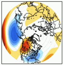 Colors show the temperature compared to average during a positive (+) PNA.
To residents of the western U.S., this looks like the weather pattern that dominated the area from late October through the first week of November. Warm and dry was the rule.
However, changes are in the mix, and rather than attempt to figure out each little up and down wiggle in the jet stream, we can take a shortcut and use the forecast for the PNA.
|
(image: Climate Prediction Center) |
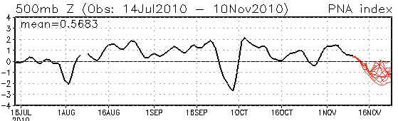
This graphic stretches from July on the left to mid-November on the right. The wavy black line shows the value of the PNA over time. After November 10th, the forecast for the PNA (the thin red lines) show that it should turn negative (-) for the next 10-15 days. A negative PNA generally means colder temperatures in the West and warmer values in the East, so rather than try to figure out each little storm as it moves across the U.S. over the next week or two, we can make an overall estimate that the West will be cold and snowy and the East will be warmer and perhaps drier.
Each red line represents a different weather computer model trying to make a forecast for the value of the PNA. Even though there is quite a bit of variability in the forecast, the consensus shows a negative PNA…so my confidence is high that the “West is best” if you want cold and snow over the next week or two!